Payl:Anguilla location map.svg

Size of this PNG preview of this SVG file: 664 x 599 ka mga piksel. Uban pang mga resoluyon: 266 x 240 ka mga piksel | 532 x 480 ka mga piksel | 851 x 768 ka mga piksel | 1,134 x 1,024 ka mga piksel | 2,269 x 2,048 ka mga piksel | 1,777 x 1,604 ka mga piksel.
Tibuok resolusyon (SVG nga payl, nominally 1,777 × 1,604 pixels, size sa payl: 56 KB)
Mubong sugid:
| Deskripsyon |
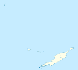
Deutsch: Positionskarte von Anguilla
Geographische Begrenzung der Karte:
English: Location map of Anguilla
Geographic limits of the map:
|
||||||||||||
| Petsa | |||||||||||||
| Gigikanan | Kaugalingong trabaho | ||||||||||||
| Tagsulat | NordNordWest | ||||||||||||
| Pagtugot (Paggamit pag-usab niini nga file) |
|
||||||||||||
| Other versions | Derivative works of this file: Anguilla islands.svg |

|
This map has been made or improved in the German Kartenwerkstatt (Map Lab). You can propose maps to improve as well.
|
Kaagi sa payl
I-klik ang petsa/oras aron makit-an ang hulagway sa payl niadtong panahona.
| Petsa/Takna | Thumbnail | Mga dimensyon | Tiggamit | Komento | |
|---|---|---|---|---|---|
| kasamtangan | 18:34, 3 Mayo 2010 | | 1,777 × 1,604 (56 KB) | NordNordWest | == {{int:filedesc}} == {{Information |Description= {{de|Positionskarte von Anguilla}} Geographische Begrenzung der Karte: * N: 18.62° N * S: 18.14° N * W: 63.46° W * O: 62.90° W {{en|Location map of Anguilla}} Geograp |
Mga paggamit sa payl
More than 100 pages use this file. The following list shows the first 100 pages that use this file only. A full list is available.
- Anguilla
- Anguilla (pagklaro)
- Barnes Bay
- Bay Rock
- Blowing Point
- Blowing Rock
- Captains Bay
- Clayton J. Lloyd International Airport
- Cove Bay
- Dog Island
- Dowling
- East Cay
- East End
- Forest Bay
- Forest Point
- George Hill
- Gibbon Point
- Gibbons Point
- Great Bay
- Hat Island
- High Cliff
- Island Harbour
- Island Head
- Limestone Bay
- Little Island
- Little Scrub Island
- Long Bay
- Long Rock
- Lovers Point
- Mead's Bay
- Mead Point
- Mid Cay
- Mimi Bay
- North Shannon Hill
- North Side
- North Side (lungsod)
- North Wager
- Prickly Pear Cays
- Rendezvous Bay (luuk sa Anggwilya)
- Road Bay
- Road Bay (luuk sa Anggwilya)
- Road Point
- Road Point (punta sa Anggwilya)
- Sand Island
- Sandy Ground Village
- Sandy Hill Bay
- Sandy Hill Bay (luuk sa Anggwilya)
- Sandy Island
- Sandy Island (pulo sa Anggwilya)
- Sandy Point
- Sandy Point (punta sa Anggwilya)
- Savannah Bay
- Savannah Bay (luuk sa Anggwilya, lat 18,23, long -62,98)
- Savannah Bay (luuk sa Anggwilya, lat 18,27, long -63,23)
- Scilly Cay
- Scrub Bay
- Scrub Island
- Scrub Island (pulo sa Anggwilya)
- Scrub Islet
- Seal Island
- Seal Island (pulo sa Anggwilya)
- Seal Islands
- Seal Islets
- Seal Rocks
- Seal Rocks (mga bato sa Anggwilya)
- Shaddick Point
- Shannon Hill
- Sherricks Bay
- Sherricks High Point
- Shoal Bay
- Shoal Bay (luuk sa Anggwilya)
- Sile Bay
- Snake Point
- Snake Point (punta sa Anggwilya)
- Sombrero (pagklaro)
- Sombrero (pulo)
- Sombrero Island
- Souse Bay
- South Wager
- Spring Bay
- Spring Bay (luuk sa Anggwilya)
- Stoney Bay
- Stoney Bay (luuk sa Anggwilya)
- Stoney Ground
- The Farrington
- The Quarter
- The Valley
- The Valley (ulohang dakbayan)
- Upper Maunday's Point
- Upper Shoal Bay
- Valley
- Warner Point
- Warner Point (punta sa Anggwilya)
- West Cay
- West Cay (pulo sa Anggwilya)
- West Point
- West Point (punta sa Anggwilya)
- Windward Point
- Windward Point (punta sa Anggwilya)
- Windward Point Bay
View more links to this file.
Global nga paggamit sa payl
Kining ubang wiki naggamit ning maong payl:
- Paggamit sa af.wikipedia.org
- Paggamit sa an.wikipedia.org
- Paggamit sa ar.wikipedia.org
- Paggamit sa ast.wikipedia.org
- Paggamit sa ba.wikipedia.org
- Paggamit sa be.wikipedia.org
- Paggamit sa bg.wikipedia.org
- Paggamit sa bs.wikipedia.org
- Paggamit sa ckb.wikipedia.org
- Paggamit sa cs.wikipedia.org
- Paggamit sa da.wikipedia.org
- Paggamit sa de.wikipedia.org
- Paggamit sa de.wikivoyage.org
- Paggamit sa el.wikipedia.org
- Paggamit sa en.wikipedia.org
View more global usage of this file.