Payl:Atauro posto administrativo.png
Gidak-on ning maong paunang tan-aw: 477 x 599 ka mga piksel. Uban pang mga resoluyon: 191 x 240 ka mga piksel | 624 x 784 ka mga piksel.
Tibuok resolusyon (624 × 784 pixels, size sa payl: 109 KB, MIME type: image/png)
Mubong sugid:
| Deskripsyon |
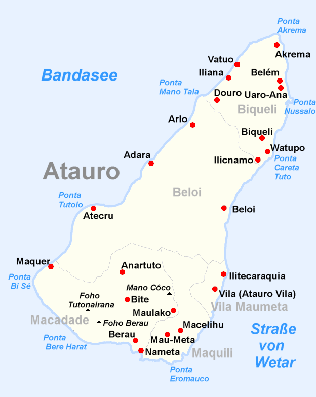
Deutsch: Verwaltungskarte Atauros English: Administrative map of Atauro/East Timor |
| Petsa | (UTC) |
| Gigikanan |
This file was derived from: Administrative map of the Dilli district of East Timor.png:  |
| Tagsulat |
| This is a retouched picture, which means that it has been digitally altered from its original version. Modifications: create map of Atauro subdistrict. The original can be viewed here: Administrative map of the Dilli district of East Timor.png:
|
Pagtugot
I, the copyright holder of this work, hereby publish it under the following license:
This file is licensed under the Creative Commons Attribution-Share Alike 2.5 Generic license.
- Libre ka:
- sa pagsabwag – sa pagkopya, pag-apod-apod ug pagsabwag sa hinimo
- sa pag-remix – sa pag-adap sa binuhat
- Ubos sa mosunod nga mga kondisyon:
- atribusyon – Kinahanglan nimo nga hatagan ang angay nga kredito, maghatag usa ka link sa lisensya, ug ipakita kung adunay mga pagbag-o. Mahimo nimo kini buhaton sa bisan unsang makatarunganon nga paagi, apan dili sa bisan unsang paagi nga nagsugyot nga gi-endorso ka sa licensor o ang imong paggamit.
- share parehas – Kung imong gi-remix, gibag-o, o gibase sa materyal, kinahanglan nimo nga iapod-apod ang imong mga kontribusyon sa ilawom sa parehas o katugma nga lisensya sama sa orihinal.
Original upload log
This image is a derivative work of the following images:
- File:Administrative_map_of_the_Dilli_district_of_East_Timor.png licensed with Cc-by-sa-2.5
- 2012-08-08T20:10:32Z NordNordWest 1441x1928 (133925 Bytes) upd
- 2009-09-22T05:17:49Z Chumwa 1441x1928 (185415 Bytes) Ausschnittvergrößreung von Dilli hinzugefügt
- 2009-09-19T06:07:46Z Chumwa 1441x1928 (135878 Bytes) {{Information |Description= {{ de }} Verwaltungskarte des Distrikts Dilli in Osttimor {{ en }} Administrative map of the Dilli district of East Timor |Source=Self made, using informations from the[http://websig.civil.ist.utl.
Uploaded with derivativeFX
Kaagi sa payl
I-klik ang petsa/oras aron makit-an ang hulagway sa payl niadtong panahona.
| Petsa/Takna | Thumbnail | Mga dimensyon | Tiggamit | Komento | |
|---|---|---|---|---|---|
| kasamtangan | 18:57, 15 Septiyembre 2012 | | 624 × 784 (109 KB) | J. Patrick Fischer | == {{int:filedesc}} == {{Information |Description={{ de }} Verwaltungskarte Atauros {{ en }} Administrative map of Atauro/East Timor |Source={{Derived from|Administrative_map_of_the_Dilli_district_of_East_Timor.png|display=50}} |Date=2012-09-15 18:54 (... |
Mga paggamit sa payl
Ang mosunod nga mga panid misumpay niining payl:
Global nga paggamit sa payl
Kining ubang wiki naggamit ning maong payl:
- Paggamit sa az.wikipedia.org
- Paggamit sa cs.wikipedia.org
- Paggamit sa de.wikipedia.org
- Paggamit sa es.wikipedia.org
- Paggamit sa et.wikipedia.org
- Paggamit sa fi.wikipedia.org
- Paggamit sa gl.wikipedia.org
- Paggamit sa it.wikipedia.org
- Paggamit sa ko.wikipedia.org
- Paggamit sa lt.wikipedia.org
- Paggamit sa no.wikipedia.org
- Paggamit sa pl.wikipedia.org
- Paggamit sa simple.wikipedia.org
- Paggamit sa tr.wikipedia.org
- Paggamit sa vi.wikipedia.org
- Paggamit sa zh-min-nan.wikipedia.org
- Paggamit sa zh.wikipedia.org