Payl:Avon Aqueduct - geograph.org.uk - 1691980.jpg
Walay mas taas nga resolusyon.
Avon_Aqueduct_-_geograph.org.uk_-_1691980.jpg (640 × 442 pixels, size sa payl: 119 KB, MIME type: image/jpeg)
Mubong sugid:
| Deskripsyon |
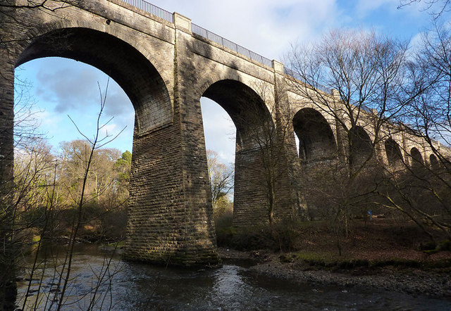
English: Avon Aqueduct This photo shows seven of the twelve arches of the Avon Aqueduct, which carries the Union Canal across the River Avon. At 247 metres long and 25.9 metres high, it is the longest and highest aqueduct in Scotland and the second longest in the UK. It was built between 1819 and 1822 by Hugh Baird (1770-1827), to a design by Thomas Telford (1757-1834) and, unusually, has a towpath on each side. |
| Petsa | |
| Gigikanan | From geograph.org.uk |
| Tagsulat | Eileen Henderson |
| Attribution (required by the license) | Eileen Henderson / Avon Aqueduct / |
| Camera location | | View this and other nearby images on: OpenStreetMap |
|---|
_heading:67.00&language=ceb)
| Object location | | View this and other nearby images on: OpenStreetMap |
|---|
_heading:67.00&language=ceb)
Pagtugot

|
This image was taken from the Geograph project collection. See this photograph's page on the Geograph website for the photographer's contact details. The copyright on this image is owned by Eileen Henderson and is licensed for reuse under the Creative Commons Attribution-ShareAlike 2.0 license.
|
This file is licensed under the Creative Commons Attribution-Share Alike 2.0 Generic license.
Attribution: Eileen Henderson
- Libre ka:
- sa pagsabwag – sa pagkopya, pag-apod-apod ug pagsabwag sa hinimo
- sa pag-remix – sa pag-adap sa binuhat
- Ubos sa mosunod nga mga kondisyon:
- atribusyon – Kinahanglan nimo nga hatagan ang angay nga kredito, maghatag usa ka link sa lisensya, ug ipakita kung adunay mga pagbag-o. Mahimo nimo kini buhaton sa bisan unsang makatarunganon nga paagi, apan dili sa bisan unsang paagi nga nagsugyot nga gi-endorso ka sa licensor o ang imong paggamit.
- share parehas – Kung imong gi-remix, gibag-o, o gibase sa materyal, kinahanglan nimo nga iapod-apod ang imong mga kontribusyon sa ilawom sa parehas o katugma nga lisensya sama sa orihinal.
Kaagi sa payl
I-klik ang petsa/oras aron makit-an ang hulagway sa payl niadtong panahona.
| Petsa/Takna | Thumbnail | Mga dimensyon | Tiggamit | Komento | |
|---|---|---|---|---|---|
| kasamtangan | 02:49, 5 Marso 2011 | | 640 × 442 (119 KB) | GeographBot | == {{int:filedesc}} == {{Information |description={{en|1=Avon Aqueduct This photo shows seven of the twelve arches of the Avon Aqueduct, which carries the Union Canal across the River Avon. At 247 metres long and 25.9 metres high, it is the longest and hi |
Mga paggamit sa payl
Ang mosunod nga 2 panid misumpay niining payl:
Global nga paggamit sa payl
Kining ubang wiki naggamit ning maong payl:
- Paggamit sa arz.wikipedia.org
- Paggamit sa ca.wikipedia.org
- Paggamit sa cs.wikipedia.org
- Paggamit sa de.wikipedia.org
- Paggamit sa en.wikipedia.org
- Paggamit sa eu.wikipedia.org
- Paggamit sa nl.wikipedia.org
- Paggamit sa www.wikidata.org