Payl:Baiyunebo ast 2006181.jpg
Walay mas taas nga resolusyon.
Baiyunebo_ast_2006181.jpg (720 × 480 pixels, size sa payl: 165 KB, MIME type: image/jpeg)
Mubong sugid:
| Deskripsyon |
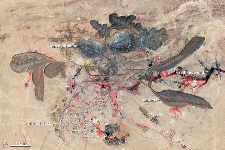
English: False-color image of Rare Earth mine in Bayan Obo (Baiyunebo), Nei Mongol Autonomous Region, China, resulting from combination of satellite images captured by ASTER (although not stated in the description on the Earth Observatory Web Site, the single-band images very likely were captured by ASTER’s VNIR subsystem, and the band combination of the corresponding multi-band image is 3-2-1, i.e. NIR-red-green) Deutsch: Falschfarben-Aufnahme des Seltene-Erden-Tagebaus in Bayan Obo (Baiyunebo), Innere Mongolei, China, erstellt durch Kombination mehrerer Aufnahmen des satellitengestützten Instruments ASTER (wenngleich es nicht ausdrücklich in der Bildbeschreibung auf der Earth-Observatory-Website steht, handelt es sich bei den Einzelbildern sehr wahrscheinlich um Aufnahmen des VNIR-Subsystems des ASTER-Instruments, und die Kanalkombination des resultierenden Multikanalbildes lautet 3-2-1, d.h. NIR-rot-grün) Beschriftung:
|
|||||
| Petsa | acquired June 30, 2006 | |||||
| Gigikanan | http://earthobservatory.nasa.gov/IOTD/view.php?id=77723&src=eoa-iotd | |||||
| Tagsulat | NASA Earth Observatory | |||||
| Pagtugot (Paggamit pag-usab niini nga file) |
|
|||||
| Other versions | File:PIA13969.jpg |

Kaagi sa payl
I-klik ang petsa/oras aron makit-an ang hulagway sa payl niadtong panahona.
| Petsa/Takna | Thumbnail | Mga dimensyon | Tiggamit | Komento | |
|---|---|---|---|---|---|
| kasamtangan | 15:40, 26 Abril 2012 | | 720 × 480 (165 KB) | Tillman | {{Information |Description ={{en|1=Rare Earth mine in Bayan Obo, China}} |Source =http://earthobservatory.nasa.gov/IOTD/view.php?id=77723&src=eoa-iotd |Author =NASA Earth Observatory |Date =acquired June 30, 2006 |Permissio... |
Mga paggamit sa payl
Ang mosunod nga mga panid misumpay niining payl:
Global nga paggamit sa payl
Kining ubang wiki naggamit ning maong payl:
- Paggamit sa ar.wikipedia.org
- Paggamit sa de.wikipedia.org
- Paggamit sa en.wikipedia.org
- Paggamit sa eu.wikipedia.org
- Paggamit sa fa.wikipedia.org
- Paggamit sa fr.wikipedia.org
- Paggamit sa he.wikipedia.org
- Paggamit sa ko.wikipedia.org
- Paggamit sa nl.wikipedia.org
- Paggamit sa pl.wikipedia.org
- Paggamit sa ru.wikipedia.org
- Paggamit sa ru.wikinews.org
- Paggamit sa sv.wikipedia.org
- Paggamit sa uk.wikipedia.org
- Paggamit sa vi.wikipedia.org
- Paggamit sa www.wikidata.org
- Paggamit sa zh.wikipedia.org