Payl:Budapest from Gellert Hill.jpg

Gidak-on ning maong paunang tan-aw: 794 x 599 ka mga piksel. Uban pang mga resoluyon: 318 x 240 ka mga piksel | 636 x 480 ka mga piksel | 1,018 x 768 ka mga piksel | 1,280 x 966 ka mga piksel | 1,632 x 1,232 ka mga piksel.
Tibuok resolusyon (1,632 × 1,232 pixels, size sa payl: 374 KB, MIME type: image/jpeg)
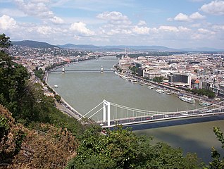
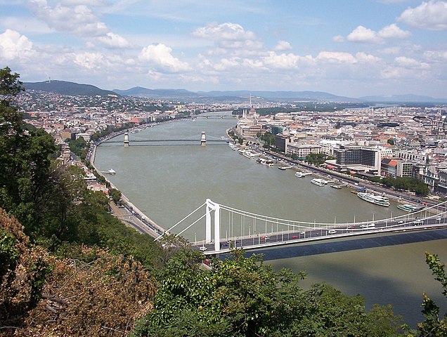
| Deskripsyon | The Hungarian capital city of Budapest, from Gellért Hill. Approximate elevation: 160 m. |
| Petsa | 12:53+02 (Europe/Budapest) |
| Gigikanan | Kaugalingong trabaho |
| Tagsulat | Gabor Eszes (UED77) |
| Pagtugot (Paggamit pag-usab niini nga file) |
Use it freely. |
| Camera location | | View this and other nearby images on: OpenStreetMap |
|---|
I, the copyright holder of this work, hereby publish it under the following licenses:

|
Gitugot ang pagkopya, pag-apud-apod o/ug pag-usab ning maong dokumento ubos sa mga termino sa GNU Free Documentation License, Version 1.2 o mas bag-ong bersiyon nga gimantala sa Free Software Foundation; nga walay Invariant Sections, walay Front-Cover Texts, ug walay Back-Cover Texts. Ang kopya sa lisensiya gilakip sa bahin nga giulohang GNU Free Documentation License. |
| This file is licensed under the Creative Commons Attribution-Share Alike 3.0 Unported license. | ||
| ||
| This licensing tag was added to this file as part of the GFDL licensing update. |
This file is licensed under the Creative Commons Attribution-Share Alike 2.5 Generic, 2.0 Generic and 1.0 Generic license.
- Libre ka:
- sa pagsabwag – sa pagkopya, pag-apod-apod ug pagsabwag sa hinimo
- sa pag-remix – sa pag-adap sa binuhat
- Ubos sa mosunod nga mga kondisyon:
- atribusyon – Kinahanglan nimo nga hatagan ang angay nga kredito, maghatag usa ka link sa lisensya, ug ipakita kung adunay mga pagbag-o. Mahimo nimo kini buhaton sa bisan unsang makatarunganon nga paagi, apan dili sa bisan unsang paagi nga nagsugyot nga gi-endorso ka sa licensor o ang imong paggamit.
- share parehas – Kung imong gi-remix, gibag-o, o gibase sa materyal, kinahanglan nimo nga iapod-apod ang imong mga kontribusyon sa ilawom sa parehas o katugma nga lisensya sama sa orihinal.
You may select the license of your choice.
|
Kaagi sa payl
I-klik ang petsa/oras aron makit-an ang hulagway sa payl niadtong panahona.
| Petsa/Takna | Thumbnail | Mga dimensyon | Tiggamit | Komento | |
|---|---|---|---|---|---|
| kasamtangan | 03:52, 3 Enero 2006 | | 1,632 × 1,232 (374 KB) | UED77 | {{Information |Description =The Hungarian capital city of Budapest, from Gellért Hill. Taken from approximately 47°29′16.13″ N 19°02′49.20″ E, facing approximately 350°. Approximate elevation: 160 m. |Source =Own work. |Date =2004-07-13 12:53+ |
Mga paggamit sa payl
Ang mosunod nga mga panid misumpay niining payl:
Global nga paggamit sa payl
Kining ubang wiki naggamit ning maong payl:
- Paggamit sa ang.wikipedia.org
- Paggamit sa an.wikipedia.org
- Paggamit sa arz.wikipedia.org
- Paggamit sa ast.wikipedia.org
- Paggamit sa av.wikipedia.org
- Paggamit sa az.wikipedia.org
- Paggamit sa ba.wikipedia.org
- Paggamit sa be.wikipedia.org
- Paggamit sa br.wikipedia.org
- Paggamit sa ca.wikipedia.org
- Paggamit sa ce.wikipedia.org
- Paggamit sa crh.wikipedia.org
- Paggamit sa cs.wikipedia.org
- Paggamit sa cv.wikipedia.org
- Paggamit sa cy.wikipedia.org
- Paggamit sa da.wikipedia.org
- Paggamit sa de.wikipedia.org
- Paggamit sa diq.wikipedia.org
- Paggamit sa el.wikipedia.org
- Paggamit sa en.wikipedia.org
- Paggamit sa en.wikivoyage.org
- Paggamit sa es.wikipedia.org
- Paggamit sa eu.wikipedia.org
- Paggamit sa fi.wikipedia.org
- Paggamit sa fr.wiktionary.org
- Paggamit sa ga.wikipedia.org
- Paggamit sa gl.wikipedia.org
- Paggamit sa he.wikipedia.org
- Paggamit sa hr.wikipedia.org
- Paggamit sa ia.wikipedia.org
- Paggamit sa incubator.wikimedia.org
- Paggamit sa inh.wikipedia.org
- Paggamit sa io.wikipedia.org
- Paggamit sa is.wikipedia.org
- Paggamit sa it.wikipedia.org
- Paggamit sa ja.wikipedia.org
- Paggamit sa kab.wikipedia.org
View more global usage of this file.