Payl:Maatsuyker Islands.jpg
Walay mas taas nga resolusyon.
Maatsuyker_Islands.jpg (640 × 480 pixels, size sa payl: 39 KB, MIME type: image/jpeg)
Mubong sugid:
| Deskripsyon |
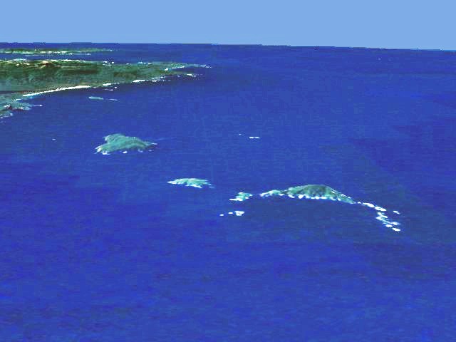
English: Aerial view of the southern coast of Tasmania. In the background South East Cape, in the foreground the Maatsuyker Islands (Needle Rocks are on the right; just to the left of them is Maatsuyker Island; De Witt is the larger island on the left). Artificial view generated from satellite data. |
| Petsa | 22 Hulyo 2006 (original upload date) |
| Gigikanan | Transferred from en.wikipedia to Commons. |
| Tagsulat | The original uploader was Phaedrus86 at English Wikipedya. |
| Pagtugot (Paggamit pag-usab niini nga file) |
I extracted this image from en:NASA World Wind, which makes it public domain because of US Government policies. It is an artificial view generated from satellite data. --Phaedrus86 03:21, 22 July 2006 (UTC) |
Pagtugot
| This image is in the public domain because it is a screenshot from NASA’s globe software World Wind using a public domain layer, such as Blue Marble, MODIS, Landsat, SRTM, USGS or GLOBE.
|
 |
Original upload log
The original description page was here. All following user names refer to en.wikipedia.
- 2006-07-22 03:20 Phaedrus86 640×480×8 (16889 bytes) I extracted this image from [[Nasa Worldwind]]. It is an artificial view generated from satellite data.
Kaagi sa payl
I-klik ang petsa/oras aron makit-an ang hulagway sa payl niadtong panahona.
| Petsa/Takna | Thumbnail | Mga dimensyon | Tiggamit | Komento | |
|---|---|---|---|---|---|
| kasamtangan | 07:30, 1 Abril 2007 | | 640 × 480 (39 KB) | Ibn Battuta | edited to increase contrast and hence visibility |
| 04:19, 1 Abril 2007 |  | 640 × 480 (16 KB) | Ibn Battuta | {{Information |Description=Aerial view of the southern coast of Tasmania. In the background South East Cape, in the foreground the Maatsuyker Islands (Needle Rocks are on the right; just to the left of th |
Mga paggamit sa payl
Ang mosunod nga mga panid misumpay niining payl:
Global nga paggamit sa payl
Kining ubang wiki naggamit ning maong payl:
- Paggamit sa de.wikipedia.org
- Paggamit sa en.wikipedia.org
- Paggamit sa eo.wikipedia.org
- Paggamit sa it.wikipedia.org
- Paggamit sa nl.wikipedia.org
- Paggamit sa ru.wikipedia.org
- Paggamit sa uk.wikipedia.org
- Paggamit sa www.wikidata.org