Payl:North, south and west elevations and sections, floor plan - Bleak Hall Plantation, Ice House, Ocella Creek, Edisto Island, Charleston County, SC HABS SC-879-A (sheet 1 of 1).tif

Tibuok resolusyon (14,400 × 9,595 pixels, size sa payl: 1,007 KB, MIME type: image/tiff)
Mubong sugid:
| Warning | The original file is very high-resolution. It might not load properly or could cause your browser to freeze when opened at full size. |
|---|
| north, south and west elevations and sections, floor plan - Bleak Hall Plantation, Ice House, Ocella Creek, Edisto Island, Charleston County, SC | ||||
|---|---|---|---|---|
| Photographer |
McNicholl, Erin, creator |
|||
| Title |
north, south and west elevations and sections, floor plan - Bleak Hall Plantation, Ice House, Ocella Creek, Edisto Island, Charleston County, SC |
|||
| Deskripsyon |
Townsend, John; Arzola, Robert, project manager |
|||
| Depicted place | South Carolina; Charleston County; Edisto Island | |||
| Petsa | 2010 | |||
| Dimensions | 24 x 36 in. (D size) | |||
| Current location |
Library of Congress Prints and Photographs Division Washington, D.C. 20540 USA http://hdl.loc.gov/loc.pnp/pp.print |
|||
| Accession number |
HABS SC-879-A (sheet 1 of 1) |
|||
| Credit line |
|
|||
| Notes |
The Smoke House is the only other extant building from the plantation and it is a tabby Greek Revival building. The Ice House is a small building with distinctive Gothic Revival trim, a steeply pitched dormer and Gothic arched shuttered windows. Two large doors on the North side of the building allow access for transferring ice in the ice house. Directly above these doors, is an upper door that provides access to the storage area in the gable. While it is now closed and used for storage, it is likely that the upper portion under the eaves housed the pulley equipment that facilitated the movement of the ice blocks. Above the ice pit the wood floor is raised and two large doors are laid on the platform that separate the floor from the tabby pit below where the ice was stored. At one time there was a double wall surrounding the area of tabby pit that helped provide insulation to maintain the ice. The evidence of the insulation wall is seen in the mortise holes in the ceiling above. One inch circular ventilation holes surround the South side of the building in the upper siding. The "anti-room" of the ice house is one step lower that the wood platform above the ice pit. Mortise holes on the interior wall and in the beams of the ceiling indicate that there used to be a partition separating the two areas. The wooden floor of the raised section has been replaces, removing any visual evidence of previous partitions. The South portion of the building has also been white washed. The building is a timber brace frame with pegged joints. There has been a large amount of material replaced over the years, though the basic structural frame is original and remains intact.
|
|||
| References |
|
|||
| Gigikanan | https://www.loc.gov/pictures/item/sc1191.sheet.00001a | |||
| Pagtugot (Paggamit pag-usab niini nga file) |
|
|||

| Object location | | View this and other nearby images on: OpenStreetMap |
|---|
Kaagi sa payl
I-klik ang petsa/oras aron makit-an ang hulagway sa payl niadtong panahona.
| Petsa/Takna | Thumbnail | Mga dimensyon | Tiggamit | Komento | |
|---|---|---|---|---|---|
| kasamtangan | 21:40, 1 Agosto 2014 | 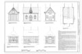 | 14,400 × 9,595 (1,007 KB) | Fæ | GWToolset: Creating mediafile for Fæ. HABS 2014-08-01 (3201:3400) |
Mga paggamit sa payl
Ang mosunod nga mga panid misumpay niining payl: