Payl:Palau location map.svg

Tibuok resolusyon (SVG nga payl, nominally 520 × 709 pixels, size sa payl: 30 KB)
Mubong sugid:
| Deskripsyon |
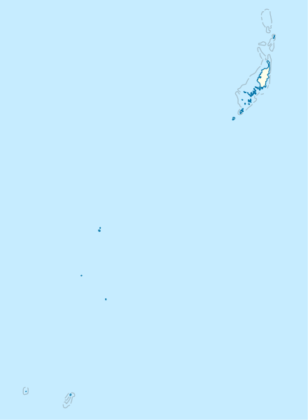
Deutsch: Positionskarte von Palau
Quadratische Plattkarte. Geographische Begrenzung der Karte:
English: Location map of Palau
Equirectangular projection. Geographic limits of the map:
|
|
| Petsa | ||
| Gigikanan |
Kaugalingong trabaho, using
|
|
| Tagsulat | NordNordWest | |
| Pagtugot (Paggamit pag-usab niini nga file) |
This file is licensed under the Creative Commons Attribution-Share Alike 3.0 Germany license.
 This file is licensed under the Creative Commons Attribution-Share Alike 3.0 Germany license.
|
|
| Other versions |
|


_location_map.svg)

|
This map has been made or improved in the German Kartenwerkstatt (Map Lab). You can propose maps to improve as well.
|
Kaagi sa payl
I-klik ang petsa/oras aron makit-an ang hulagway sa payl niadtong panahona.
| Petsa/Takna | Thumbnail | Mga dimensyon | Tiggamit | Komento | |
|---|---|---|---|---|---|
| kasamtangan | 16:02, 14 Nobiyembre 2009 | | 520 × 709 (30 KB) | NordNordWest | == {{int:filedesc}} == {{Information |Description= {{de|Positionskarte von Palau}} Quadratische Plattkarte. Geographische Begrenzung der Karte: * N: 8.6° N * S: 2.6° N * W: 130.8° O * O: 135.2° O {{en|Location map of Palau} |
Mga paggamit sa payl
More than 100 pages use this file. The following list shows the first 100 pages that use this file only. A full list is available.
- Amoi
- Angelul
- Angour
- Aulong
- Ayas
- Banna
- Belau
- Blasted Boat Canal
- Blasted Reef Channel
- Chol
- Coral Dredging Basin
- Current Island
- Denges
- Desomel
- Doro Island
- East Entrance
- Eil Malk
- Engas
- Fanna
- Garaseg
- Gorak
- Guat Island
- Gurer Island
- Helen Island
- Heren-Shō
- Higashi
- Higashi-Suido
- Ika
- Ika Island
- Jellyfish Lake
- Johnstone
- Kamori
- Kawassak
- Kita
- Korak
- Koror
- Kossol Passage
- Lighthouse Channel
- Limestone Ridge
- Long Island
- Lookout Island
- Malakal
- Matol
- Mecherchar Islands
- Meriel
- Monkey Island
- Moore Island
- Mount Tuns
- Murphy
- Nakano
- Nakano Island
- Namai
- Namai Bay
- Neville Island
- Ngarua
- Ngaruang
- Ngaruangl
- Ngaruangl Island
- Ngerebelas
- Ngerikuul
- Ngeruangel
- Ngeruktabel Islands
- Ngis
- Ngkesill
- Nishi
- Nishi-suidō
- North Entrance
- North Passage
- Oruregiru
- Palos
- Peaked Hill
- Peaked Island
- Pul
- Pulo (pagklaro)
- Pulo Maria
- Pur
- Puro
- Puru
- Rock Islands
- Saddle Mount
- Saddle Mountain
- Saint Andrew Islands
- Saint André
- Saipan
- San Andreas
- San Andres
- San Carlos
- Sonsorol
- Sonsorol Islands
- Telong
- Tobi
- Tobi Island
- US National Register of Historic Places
- Ueno
- Ulong
- Ulong Islands
- Walau
- West Channel
- West Entrance
- West Passage
View more links to this file.
Global nga paggamit sa payl
Kining ubang wiki naggamit ning maong payl:
- Paggamit sa af.wikipedia.org
- Paggamit sa an.wikipedia.org
- Paggamit sa ar.wikipedia.org
- Paggamit sa ast.wikipedia.org
- Paggamit sa az.wikipedia.org
- Paggamit sa bcl.wikipedia.org
- Paggamit sa be-tarask.wikipedia.org
- Paggamit sa be.wikipedia.org
- Paggamit sa bg.wikipedia.org
- Paggamit sa bn.wikipedia.org
- Paggamit sa bs.wikipedia.org
- Paggamit sa ckb.wikipedia.org
- Paggamit sa crh.wikipedia.org
- Paggamit sa cs.wikipedia.org
- Paggamit sa da.wikipedia.org
- Paggamit sa de.wikipedia.org
View more global usage of this file.