Payl:Tour Solidor DSC 6316-1.JPG

Gidak-on ning maong paunang tan-aw: 800 x 532 ka mga piksel. Uban pang mga resoluyon: 320 x 213 ka mga piksel | 640 x 426 ka mga piksel | 1,024 x 681 ka mga piksel | 1,280 x 851 ka mga piksel | 3,008 x 2,000 ka mga piksel.
Tibuok resolusyon (3,008 × 2,000 pixels, size sa payl: 1.04 MB, MIME type: image/jpeg)
Mubong sugid:
| Deskripsyon |
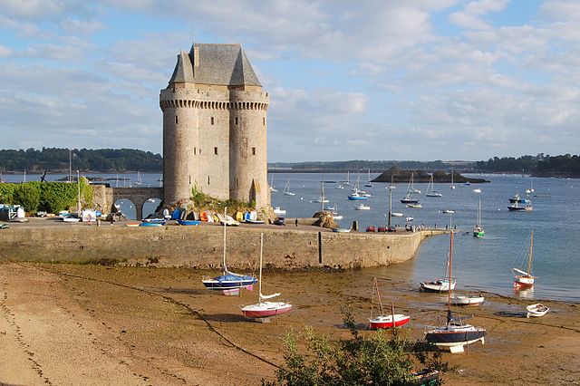
English: The Solidor tower in the estuary of the river Rance in Brittany (France). It was built between 1369 and 1382 by John V, Duke of Brittany (i.e. Jean IV in French) to control access to the Rance at a time when the city of Saint-Malo did not recognize his authority. Over the centuries the tower lost its military interest and became a jail. It is now a museum celebrating Breton sailors exploring Cape Horn. The Solidor tower is located in the former city of Saint-Servan, which merged with Saint-Malo in 1967.
Français : La tour Solidor dans l'estuaire de la Rance près de Saint Malo (Bretagne, France). Ce donjon fut construit entre 1369 et 1382, par le duc Jean IV de Bretagne afin d'avoir un contrôle sur la Rance à une époque où la ville de Saint-Malo était rebelle à son autorité. L'histoire et l'évolution des technologies militaires ayant rendu son usage initial caduc, la tour est transformée en prison pendant la Révolution et l'Empire. Elle héberge depuis 1970 un musée des cap-horniers qui réunit les collections du musée de Saint-Malo sur la navigation au long cours et les cap-horniers (cartes,maquettes,instruments de navigation...). La tour Solidor est située à Saint-Servan, ancienne commune devenue un quartier de la ville de Saint-Malo après une fusion intervenue en 1967. |
| Petsa | |
| Gigikanan | Kaugalingong trabaho |
| Tagsulat | Pline |
| Camera location | | View this and other nearby images on: OpenStreetMap |
|---|
|
This building is indexed in the base Mérimée, a database of architectural heritage maintained by the French Ministry of Culture, under the reference PA00090871
|
Pagtugot
I, the copyright holder of this work, hereby publish it under the following licenses:

|
Gitugot ang pagkopya, pag-apud-apod o/ug pag-usab ning maong dokumento ubos sa mga termino sa GNU Free Documentation License, Version 1.2 o mas bag-ong bersiyon nga gimantala sa Free Software Foundation; nga walay Invariant Sections, walay Front-Cover Texts, ug walay Back-Cover Texts. Ang kopya sa lisensiya gilakip sa bahin nga giulohang GNU Free Documentation License. |
This file is licensed under the Creative Commons Attribution-Share Alike 3.0 Unported, 2.5 Generic, 2.0 Generic and 1.0 Generic license.
- Libre ka:
- sa pagsabwag – sa pagkopya, pag-apod-apod ug pagsabwag sa hinimo
- sa pag-remix – sa pag-adap sa binuhat
- Ubos sa mosunod nga mga kondisyon:
- atribusyon – Kinahanglan nimo nga hatagan ang angay nga kredito, maghatag usa ka link sa lisensya, ug ipakita kung adunay mga pagbag-o. Mahimo nimo kini buhaton sa bisan unsang makatarunganon nga paagi, apan dili sa bisan unsang paagi nga nagsugyot nga gi-endorso ka sa licensor o ang imong paggamit.
- share parehas – Kung imong gi-remix, gibag-o, o gibase sa materyal, kinahanglan nimo nga iapod-apod ang imong mga kontribusyon sa ilawom sa parehas o katugma nga lisensya sama sa orihinal.
You may select the license of your choice.

|
This image has been assessed under the valued image criteria and is considered the most valued image on Commons within the scope: Tour Solidor. You can see its nomination here. |
Kaagi sa payl
I-klik ang petsa/oras aron makit-an ang hulagway sa payl niadtong panahona.
| Petsa/Takna | Thumbnail | Mga dimensyon | Tiggamit | Komento | |
|---|---|---|---|---|---|
| kasamtangan | 22:42, 3 Septiyembre 2008 | | 3,008 × 2,000 (1.04 MB) | Pline | {{Information |Description={{en|1=The Solidor tower in the estuary of the river Rance in Brittany (France)}} {{fr|1=La tour Solidor dans l'estuaire de la Rance près de Saint Malo (Bretagne, France)}} |Source=travail personnel (own work) |Author=[[User:Pl |
Mga paggamit sa payl
Ang mosunod nga mga panid misumpay niining payl:
Global nga paggamit sa payl
Kining ubang wiki naggamit ning maong payl:
- Paggamit sa de.wikipedia.org
- Paggamit sa de.wikivoyage.org
- Paggamit sa en.wikipedia.org
- Paggamit sa es.wikipedia.org
- Paggamit sa eu.wikipedia.org
- Paggamit sa fr.wikipedia.org
- Saint-Malo
- Tour Solidor
- Utilisateur:Pline/Illustrations
- Utilisateur:Pline/photos Saint-Malo
- Liste des monuments historiques de Saint-Malo
- Portail:Duché de Bretagne/Image du jour
- Portail:Duché de Bretagne/Image du jour/12
- Projet:Monuments historiques/Wikidata/liste/35
- Liste des châteaux d'Ille-et-Vilaine
- Liste des musées d'Ille-et-Vilaine
- Paggamit sa fr.wikivoyage.org
- Paggamit sa pt.wikipedia.org
- Paggamit sa www.wikidata.org
- Paggamit sa zh.wikipedia.org