Payl:1632 Cardona Descripcion Indias (11).jpg

Tibuok resolusyon (2,930 × 1,953 pixels, size sa payl: 524 KB, MIME type: image/jpeg)
.jpg)
Mubong sugid:
| Deskripsyon |
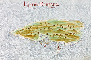
Español: Mapa español de 1632 de la isla del Barbado (actual Barbados). Página 11 de las Descripciones geográficas e hidrográficas de muchas tierras y mares del Norte y Sur en las Indias, en especial del descubrimiento del Reino de la California redactadas por el capitán Nicolás de Cardona tras su expedición de 1614.
English: Spanish 1632 map of the island of Barbados. Page 11 of the Descripciones geográficas e hidrográficas de muchas tierras y mares del Norte y Sur en las Indias, en especial del descubrimiento del Reino de la California (Geographic and hydrographic descriptions of many northern and southern lands and seas in the Indies, specifically the discovery of the kingdom of California), written by captain Nicolás de Cardona after his expedition of 1614. |
|||||||||||||||||||
| Petsa | ||||||||||||||||||||
| Gigikanan |
Descripciones geográficas e hidrográficas de muchas tierras y mares del Norte y Sur en las Indias, en especial del descubrimiento del Reino de California hecho con trabajo e industria por el capitán y cabo Nicolás de Cardona ... dirigidas al Exmo. D. Gaspar de Guzmán, Conde de Olivares ... Biblioteca Digital Hispánica (Biblioteca Nacional de España) |
|||||||||||||||||||
| Tagsulat |
|
|||||||||||||||||||
Pagtugot
|
This is a faithful photographic reproduction of a two-dimensional, public domain work of art. The work of art itself is in the public domain for the following reason:
The official position taken by the Wikimedia Foundation is that "faithful reproductions of two-dimensional public domain works of art are public domain".
This photographic reproduction is therefore also considered to be in the public domain in the United States. In other jurisdictions, re-use of this content may be restricted; see Reuse of PD-Art photographs for details. | ||||
Kaagi sa payl
I-klik ang petsa/oras aron makit-an ang hulagway sa payl niadtong panahona.
| Petsa/Takna | Thumbnail | Mga dimensyon | Tiggamit | Komento | |
|---|---|---|---|---|---|
| kasamtangan | 18:26, 18 Septiyembre 2023 | | 2,930 × 1,953 (524 KB) | Beao | Cropped 8 % horizontally, 10 % vertically using CropTool with lossless mode. Removed watermark. |
| 23:29, 5 Marso 2016 |  | 3,184 × 2,165 (650 KB) | Hispalois | User created page with UploadWizard |
Mga paggamit sa payl
Ang mosunod nga mga panid misumpay niining payl:
Global nga paggamit sa payl
Kining ubang wiki naggamit ning maong payl:
- Paggamit sa arz.wikipedia.org
- Paggamit sa as.wikipedia.org
- Paggamit sa be-tarask.wikipedia.org
- Paggamit sa bn.wikipedia.org
- Paggamit sa cs.wikipedia.org
- Paggamit sa el.wikipedia.org
- Paggamit sa en.wikipedia.org
- Paggamit sa es.wikipedia.org
- Paggamit sa eu.wikipedia.org
- Paggamit sa fr.wikipedia.org
- Paggamit sa he.wikipedia.org
- Paggamit sa hy.wikipedia.org
- Paggamit sa id.wikipedia.org
- Paggamit sa io.wikipedia.org
- Paggamit sa ka.wikipedia.org
- Paggamit sa ru.wikipedia.org
- Paggamit sa uk.wikipedia.org
.jpg)