Payl:Aerial view of Hadleigh centre in the snow - geograph.org.uk - 1563668.jpg
Walay mas taas nga resolusyon.
Aerial_view_of_Hadleigh_centre_in_the_snow_-_geograph.org.uk_-_1563668.jpg (640 × 503 pixels, size sa payl: 301 KB, MIME type: image/jpeg)
Mubong sugid:
| Deskripsyon |
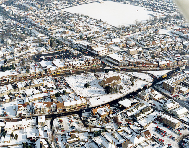
English: Aerial view of Hadleigh centre in the snow The church in the middle of the picture is St James-the-less. The large building below left of this is The Castle pub. Most of the buildings lining the major roads here are shops. The large white rectangle at the top is a school playing field, with the school to the right. |
| Petsa | |
| Gigikanan | From geograph.org.uk |
| Tagsulat | Edward Clack |
| Attribution (required by the license) | Edward Clack / Aerial view of Hadleigh centre in the snow / |
| Camera location | | View this and other nearby images on: OpenStreetMap |
|---|
_heading:67.00&language=ceb)
| Object location | | View this and other nearby images on: OpenStreetMap |
|---|
_heading:67.00&language=ceb)
Pagtugot

|
This image was taken from the Geograph project collection. See this photograph's page on the Geograph website for the photographer's contact details. The copyright on this image is owned by Edward Clack and is licensed for reuse under the Creative Commons Attribution-ShareAlike 2.0 license.
|
This file is licensed under the Creative Commons Attribution-Share Alike 2.0 Generic license.
Attribution: Edward Clack
- Libre ka:
- sa pagsabwag – sa pagkopya, pag-apod-apod ug pagsabwag sa hinimo
- sa pag-remix – sa pag-adap sa binuhat
- Ubos sa mosunod nga mga kondisyon:
- atribusyon – Kinahanglan nimo nga hatagan ang angay nga kredito, maghatag usa ka link sa lisensya, ug ipakita kung adunay mga pagbag-o. Mahimo nimo kini buhaton sa bisan unsang makatarunganon nga paagi, apan dili sa bisan unsang paagi nga nagsugyot nga gi-endorso ka sa licensor o ang imong paggamit.
- share parehas – Kung imong gi-remix, gibag-o, o gibase sa materyal, kinahanglan nimo nga iapod-apod ang imong mga kontribusyon sa ilawom sa parehas o katugma nga lisensya sama sa orihinal.
Kaagi sa payl
I-klik ang petsa/oras aron makit-an ang hulagway sa payl niadtong panahona.
| Petsa/Takna | Thumbnail | Mga dimensyon | Tiggamit | Komento | |
|---|---|---|---|---|---|
| kasamtangan | 16:01, 3 Marso 2011 | | 640 × 503 (301 KB) | GeographBot | == {{int:filedesc}} == {{Information |description={{en|1=Aerial view of Hadleigh centre in the snow The church in the middle of the picture is St James-the-less. The large building below left of this is The Castle pub. Most of the buildings lining the maj |
Mga paggamit sa payl
Ang mosunod nga mga panid misumpay niining payl:
Global nga paggamit sa payl
Kining ubang wiki naggamit ning maong payl:
- Paggamit sa af.wikipedia.org
- Paggamit sa azb.wikipedia.org
- Paggamit sa cy.wikipedia.org
- Paggamit sa en.wikipedia.org
- Paggamit sa fa.wikipedia.org
- Paggamit sa fr.wikipedia.org
- Paggamit sa ga.wikipedia.org
- Paggamit sa it.wikipedia.org
- Paggamit sa lld.wikipedia.org
- Paggamit sa nl.wikipedia.org
- Paggamit sa sv.wikipedia.org
- Paggamit sa vo.wikipedia.org
- Paggamit sa www.wikidata.org