Payl:American Samoa location map.svg

Size of this PNG preview of this SVG file: 614 x 506 ka mga piksel. Uban pang mga resoluyon: 291 x 240 ka mga piksel | 583 x 480 ka mga piksel | 932 x 768 ka mga piksel | 1,243 x 1,024 ka mga piksel | 2,485 x 2,048 ka mga piksel.
Tibuok resolusyon (SVG nga payl, nominally 614 × 506 pixels, size sa payl: 15 KB)
Mubong sugid:
| Deskripsyon |
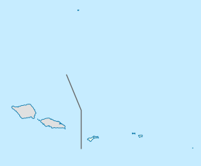
Deutsch: Positionskarte von Amerikanisch-Samoa
Quadratische Plattkarte, N-S-Streckung 102 %. Geographische Begrenzung der Karte:
English: Location map of American Samoa
Equirectangular projection, N/S stretching 102 %. Geographic limits of the map:
|
||
| Petsa | |||
| Gigikanan |
Kaugalingong trabaho, using
|
||
| Tagsulat | NordNordWest | ||
| Pagtugot (Paggamit pag-usab niini nga file) |
I, the copyright holder of this work, hereby publish it under the following license: This file is licensed under the Creative Commons Attribution-Share Alike 3.0 Unported license.
|
||
| SVG genesis | This locator map was created with Adobe Illustrator by NordNordWest.
|

Kaagi sa payl
I-klik ang petsa/oras aron makit-an ang hulagway sa payl niadtong panahona.
| Petsa/Takna | Thumbnail | Mga dimensyon | Tiggamit | Komento | |
|---|---|---|---|---|---|
| kasamtangan | 19:05, 10 Oktubre 2009 | | 614 × 506 (15 KB) | NordNordWest | {{int:filedesc}} {{Information |Description= {{de|Positionskarte von Amerikanisch-Samoa}} Quadratische Plattkarte, N-S-Streckung 102 %. Geographische Begrenzung der Karte: * N: 10.8° S * S: 15.0° S * W: 173.1° W * O: 167.9° |
Mga paggamit sa payl
More than 100 pages use this file. The following list shows the first 100 pages that use this file only. A full list is available.
- Aasu
- Aasu Stream
- Afao
- Afao (lungsod)
- Afimuao Ridge
- Afimuao Stream
- Afu Stream
- Afuelo Stream
- Afulei Stream
- Afutele Stream
- Aga Stream
- Agalua Rock
- Agaoleatu Point
- Agapie Cove
- Agaputuputu Stream
- Agasavili Point
- Agasii Stream
- Agatoavalu Rock
- Alaeli Ridge
- Alao
- Alatele Cove
- Alava Mountain
- Alega Beach
- Alega Stream
- Alegā Valley
- Alei Ridge
- Alei Stream
- Alei Stream (suba, lat -14,17, long -169,61)
- Alei Stream (suba, lat -14,17, long -169,68)
- Alili Spring
- Alili Spring (tubud sa Amerikanhong Samowa)
- Alofau
- Amaua
- Anapeapea Point
- Anua (pagklaro)
- Aonoi Stream
- Asaga Strait
- Aua
- Blasted Reef Pass
- Cape Larsen
- Coconut Point
- Craggy Point
- Faasouga Point
- Faatafa Rocks
- Fagalua Cove
- Fagatele Point
- Faleselau Ridge
- Flowerpot Rocks
- Goat Island Point
- Happy Valley
- Jennings Island
- Larsen Bay
- Leafu Stream
- Leauga Ridge
- Leaveave Stream
- Leele Stream
- Leone
- Leopard Point
- Lepua Point
- Malo Point
- Massacre Bay
- Matautu Point
- Matautuloa Point
- Matautuloa Point (punta sa Eastern District)
- Maugaleoo Ridge
- Mulivai Stream
- Niuloa Point
- Nu'utele Island
- Ofu
- Ofu Island
- Pago Stream
- Pala Lagoon
- Puna Stream
- Red Lake
- Rocky Point
- Rose Island
- Samoa Islands
- Sand Island
- Solo Hill
- Solo Point
- Solo Point (punta sa Amerikanhong Samowa)
- Square Head
- Swains Island
- Tafuna
- Tau
- Taumata Stream
- Tia Ridge
- Tiatele Ridge
- Tula (pagklaro)
- Tāfeu Cove
- Utulei
- Vailoa Stream
- Vaiola Stream
- Vaipito Stream
- Vaisa Stream
- Vaitai Stream
- Vaitele Point
- Vaitele Stream
- Western District
- Whale Rock
View more links to this file.
Global nga paggamit sa payl
Kining ubang wiki naggamit ning maong payl:
- Paggamit sa af.wikipedia.org
- Paggamit sa ar.wikipedia.org
- Paggamit sa ast.wikipedia.org
- Paggamit sa azb.wikipedia.org
- Paggamit sa az.wikipedia.org
- Paggamit sa ba.wikipedia.org
- Paggamit sa be-tarask.wikipedia.org
- Paggamit sa bg.wikipedia.org
- Paggamit sa bn.wikipedia.org
- Paggamit sa ce.wikipedia.org
- Paggamit sa ckb.wikipedia.org
- Paggamit sa cs.wikipedia.org
- Paggamit sa da.wikipedia.org
- Paggamit sa de.wikipedia.org
View more global usage of this file.