Payl:Ancient Papal State border, (Beltiglio, Ceppaloni).jpg

Gidak-on ning maong paunang tan-aw: 401 x 600 ka mga piksel. Uban pang mga resoluyon: 160 x 240 ka mga piksel | 428 x 640 ka mga piksel.
Tibuok resolusyon (428 × 640 pixels, size sa payl: 152 KB, MIME type: image/jpeg)
.jpg)
Mubong sugid:
| Object location | | View this and other nearby images on: OpenStreetMap |
|---|
.jpg¶ms=041.066600_N_0014.752990_E_globe:Earth_class:object_type:object__&language=ceb)
| Deskripsyon |
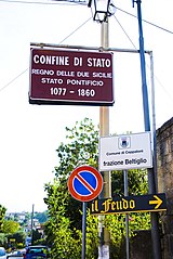
Italiano: Beltiglio, frazione di Ceppaloni: indicazione turistica del passato confine tra Regno delle Due Sicilie e Stato Pontificio. |
| Petsa | |
| Gigikanan | Ceppaloni (BN), frazione Beltiglio: ex confine di ex stati. |
| Tagsulat | Fiore Silvestro Barbato from Napoli (NA), Italy |
| Camera location | | View this and other nearby images on: OpenStreetMap |
|---|
.jpg¶ms=041.052220_N_0014.743609_E_globe:Earth_type:camera_source:Flickr_&language=ceb)
Pagtugot
This file is licensed under the Creative Commons Attribution-Share Alike 2.0 Generic license.
- Libre ka:
- sa pagsabwag – sa pagkopya, pag-apod-apod ug pagsabwag sa hinimo
- sa pag-remix – sa pag-adap sa binuhat
- Ubos sa mosunod nga mga kondisyon:
- atribusyon – Kinahanglan nimo nga hatagan ang angay nga kredito, maghatag usa ka link sa lisensya, ug ipakita kung adunay mga pagbag-o. Mahimo nimo kini buhaton sa bisan unsang makatarunganon nga paagi, apan dili sa bisan unsang paagi nga nagsugyot nga gi-endorso ka sa licensor o ang imong paggamit.
- share parehas – Kung imong gi-remix, gibag-o, o gibase sa materyal, kinahanglan nimo nga iapod-apod ang imong mga kontribusyon sa ilawom sa parehas o katugma nga lisensya sama sa orihinal.
| This image, originally posted to Flickr, was reviewed on 26 February 2012 by the administrator or reviewer Materialscientist, who confirmed that it was available on Flickr under the stated license on that date. |

|
Attribution information, such as the author's name, e-mail, website, or signature, that was once visible in the image itself has been moved into the image metadata and/or image description page. This makes the image easier to reuse and more language-neutral, and makes the text easier to process and search for. Commons discourages placing visible author information in images.
|
Kaagi sa payl
I-klik ang petsa/oras aron makit-an ang hulagway sa payl niadtong panahona.
| Petsa/Takna | Thumbnail | Mga dimensyon | Tiggamit | Komento | |
|---|---|---|---|---|---|
| kasamtangan | 21:24, 31 Agosto 2012 | | 428 × 640 (152 KB) | Decan | Watermark removed |
| 09:23, 26 Pebrero 2012 |  | 428 × 640 (196 KB) | Threecharlie | =={{int:filedesc}}== {{Information |Description={{Beltiglio, frazione di Ceppaloni: indicazione turistica del passato confine tra Regno delle Due Sicilie e Stato Pontificio.}} |Source=[http://www.flickr.com/photos/fiore_barbato/3923151218/ Ceppaloni (B... |
Mga paggamit sa payl
Ang mosunod nga mga panid misumpay niining payl:
Global nga paggamit sa payl
Kining ubang wiki naggamit ning maong payl:
- Paggamit sa bg.wikipedia.org
- Paggamit sa br.wikipedia.org
- Paggamit sa ce.wikipedia.org
- Paggamit sa es.wikipedia.org
- Paggamit sa eu.wikipedia.org
- Paggamit sa fr.wikipedia.org
- Paggamit sa hu.wikipedia.org
- Paggamit sa hy.wikipedia.org
- Paggamit sa ia.wikipedia.org
- Paggamit sa it.wikipedia.org
- Paggamit sa ko.wikipedia.org
- Paggamit sa lld.wikipedia.org
- Paggamit sa lmo.wikipedia.org
- Paggamit sa pl.wikipedia.org
- Paggamit sa pt.wikipedia.org
- Paggamit sa roa-tara.wikipedia.org
- Paggamit sa ro.wikipedia.org
- Paggamit sa ru.wikipedia.org
- Paggamit sa sr.wikipedia.org
- Paggamit sa tt.wikipedia.org
- Paggamit sa uk.wikipedia.org
- Paggamit sa uz.wikipedia.org
- Paggamit sa vec.wikipedia.org
- Paggamit sa www.wikidata.org
.jpg)