Payl:Anjouan (Comoros) map.jpg
Walay mas taas nga resolusyon.
Anjouan_(Comoros)_map.jpg (350 × 382 pixels, size sa payl: 23 KB, MIME type: image/jpeg)
Mubong sugid:
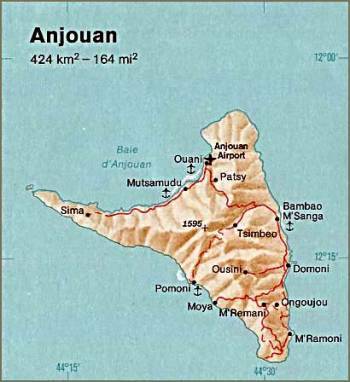
| Deskripsyon | Anjouan. From The Indian Ocean Atlas, CIA, 1976. |
| Petsa | |
| Gigikanan | University of Texas Libraries, Perry-Castañeda Library Map Collection: Comoros Maps (extracted) |
| Tagsulat | CIA |
| Other versions |

_map.jpg)
Pagtugot
| This image is a work of a Central Intelligence Agency employee, taken or made as part of that person's official duties. As a Work of the United States Government, this image or media is in the public domain in the United States.
|

|
Kaagi sa payl
I-klik ang petsa/oras aron makit-an ang hulagway sa payl niadtong panahona.
| Petsa/Takna | Thumbnail | Mga dimensyon | Tiggamit | Komento | |
|---|---|---|---|---|---|
| kasamtangan | 04:21, 8 Septiyembre 2007 | | 350 × 382 (23 KB) | BetacommandBot | Transwiki approved by: w:en:User:Dmcdevit This image was copied from wikipedia:en. The original description was: (Detailed map of Anjouan(Comoros) from http://www.lib.utexas.edu/maps/africa.html) {{PD-USGov-CIA}} === File history === {| class=wi |
Mga paggamit sa payl
Ang mosunod nga 2 panid misumpay niining payl:
Global nga paggamit sa payl
Kining ubang wiki naggamit ning maong payl:
- Paggamit sa arz.wikipedia.org
- Paggamit sa az.wikipedia.org
- Paggamit sa bg.wikipedia.org
- Paggamit sa ca.wikipedia.org
- Paggamit sa cs.wikipedia.org
- Paggamit sa de.wikipedia.org
- Paggamit sa en.wikipedia.org
- Paggamit sa eo.wikipedia.org
- Paggamit sa es.wikipedia.org
- Paggamit sa eu.wikipedia.org
- Paggamit sa fa.wikipedia.org
- Paggamit sa fi.wikipedia.org
- Paggamit sa hu.wikipedia.org
- Paggamit sa ja.wikipedia.org
- Paggamit sa mg.wikipedia.org
- Paggamit sa ms.wikipedia.org
- Paggamit sa nl.wikipedia.org
- Paggamit sa pt.wikipedia.org
- Paggamit sa ru.wikipedia.org
- Paggamit sa sv.wikipedia.org
- Paggamit sa sw.wikipedia.org
- Paggamit sa uk.wikipedia.org
- Paggamit sa www.wikidata.org
- Paggamit sa zh.wikipedia.org
_map.jpg)