Payl:Ant-pen-map-Brabant.PNG

Gidak-on ning maong paunang tan-aw: 436 x 599 ka mga piksel. Uban pang mga resoluyon: 175 x 240 ka mga piksel | 349 x 480 ka mga piksel | 720 x 989 ka mga piksel.
Tibuok resolusyon (720 × 989 pixels, size sa payl: 256 KB, MIME type: image/png)
Mubong sugid:
| Deskripsyon |
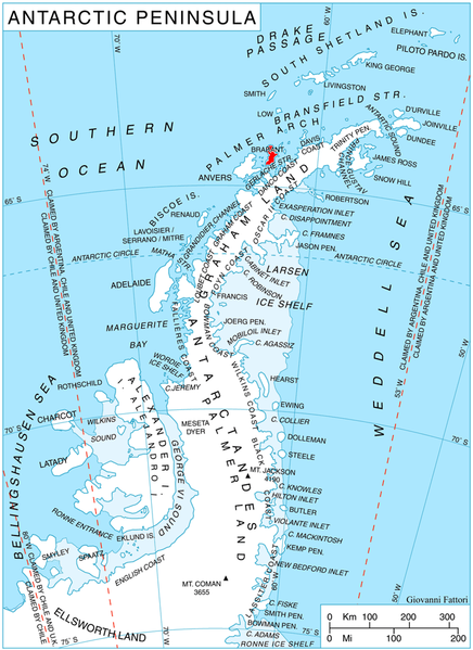
English: Location of Brabant Island, Antarctica. |
| Petsa | |
| Gigikanan | Kaugalingong trabaho, using map File:Ant-pen map.png by Giovanni Fattori. |
| Tagsulat | Edited by Apcbg |
Pagtugot
I, the copyright holder of this work, hereby publish it under the following licenses:
This file is licensed under the Creative Commons Attribution-Share Alike 3.0 Unported license.
- Libre ka:
- sa pagsabwag – sa pagkopya, pag-apod-apod ug pagsabwag sa hinimo
- sa pag-remix – sa pag-adap sa binuhat
- Ubos sa mosunod nga mga kondisyon:
- atribusyon – Kinahanglan nimo nga hatagan ang angay nga kredito, maghatag usa ka link sa lisensya, ug ipakita kung adunay mga pagbag-o. Mahimo nimo kini buhaton sa bisan unsang makatarunganon nga paagi, apan dili sa bisan unsang paagi nga nagsugyot nga gi-endorso ka sa licensor o ang imong paggamit.
- share parehas – Kung imong gi-remix, gibag-o, o gibase sa materyal, kinahanglan nimo nga iapod-apod ang imong mga kontribusyon sa ilawom sa parehas o katugma nga lisensya sama sa orihinal.

|
Gitugot ang pagkopya, pag-apud-apod o/ug pag-usab ning maong dokumento ubos sa mga termino sa GNU Free Documentation License, Version 1.2 o mas bag-ong bersiyon nga gimantala sa Free Software Foundation; nga walay Invariant Sections, walay Front-Cover Texts, ug walay Back-Cover Texts. Ang kopya sa lisensiya gilakip sa bahin nga giulohang GNU Free Documentation License. |
You may select the license of your choice.
Kaagi sa payl
I-klik ang petsa/oras aron makit-an ang hulagway sa payl niadtong panahona.
| Petsa/Takna | Thumbnail | Mga dimensyon | Tiggamit | Komento | |
|---|---|---|---|---|---|
| kasamtangan | 14:32, 25 Abril 2010 | | 720 × 989 (256 KB) | Apcbg | {{Information |Description={{en|1=Location of Brabant Island, Antarctica.}} |Source={{own}}, using map File:Ant-pen map.png by Giovanni Fattori. |Author=Edited by Apcbg |Date=2010-04-25 |Permission= |other_versions= }} [[Category:Loca |
Mga paggamit sa payl
Ang mosunod nga mga panid misumpay niining payl:
Global nga paggamit sa payl
Kining ubang wiki naggamit ning maong payl:
- Paggamit sa ar.wikipedia.org
- Paggamit sa az.wikipedia.org
- Paggamit sa bg.wikipedia.org
- Paggamit sa ca.wikipedia.org
- Paggamit sa de.wikipedia.org
- Paggamit sa en.wikipedia.org
- Brabant Island
- Lecointe Island
- Mount Hunter (Antarctica)
- Albena Peninsula
- Petroff Point
- Djerassi Glacier
- Pirogov Glacier
- Dimkov Glacier
- Thamyris Glacier
- Rhesus Glacier
- Mitev Glacier
- Kostur Point
- Grigorov Glacier
- Chumerna Glacier
- Mount Cabeza
- Cushing Peak
- Jenner Glacier
- Koch Glacier
- Guyou Bay
- Pare Glacier
- Einthoven Hill
- Pasteur Peninsula
- Galen Peak
- Harvey Heights (Antarctica)
- Hippocrates Glacier
- Hill Bay
- Mackenzie Glacier
- Malpighi Glacier
- Solvay Mountains
- Kayak Bay
- Rush Glacier
- Laënnec Glacier
- Lanusse Bay
- Lister Glacier (Palmer Archipelago)
- Eastern Dallmann Bay Antarctic Specially Protected Area
- Paprat Peak
- Kondolov Peak
- Sheynovo Peak
- Zabel Point
- Devene Point
- Buragara Cove
View more global usage of this file.