Payl:Arrondissement Virton Belgium Map.png
Walay mas taas nga resolusyon.
Arrondissement_Virton_Belgium_Map.png (220 × 290 pixels, size sa payl: 5 KB, MIME type: image/png)
Mubong sugid:
| Deskripsyon |
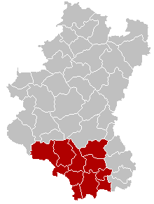
English: Map of Virton District in province of Luxembourg, Belgium.
Français : Carte indiquant la localisation de l'arrondissement de Virton dans la province de Luxembourg. |
| Gigikanan | Kaugalingong trabaho |
| Tagsulat | LennartBolks, colors by Nicnac25 |
Pagtugot
| This work has been released into the public domain by its author, LennartBolks. This applies worldwide. In some countries this may not be legally possible; if so: |
Kaagi sa payl
I-klik ang petsa/oras aron makit-an ang hulagway sa payl niadtong panahona.
| Petsa/Takna | Thumbnail | Mga dimensyon | Tiggamit | Komento | |
|---|---|---|---|---|---|
| kasamtangan | 19:14, 26 Pebrero 2005 | | 220 × 290 (5 KB) | Nicnac25~commonswiki | Map of Virton District in province of Luxembourg, Belgium |
Mga paggamit sa payl
Ang mosunod nga mga panid misumpay niining payl:
Global nga paggamit sa payl
Kining ubang wiki naggamit ning maong payl:
- Paggamit sa bg.wikipedia.org
- Paggamit sa br.wikipedia.org
- Paggamit sa bs.wikipedia.org
- Paggamit sa cs.wikipedia.org
- Paggamit sa de.wikipedia.org
- Paggamit sa es.wikipedia.org
- Paggamit sa et.wikipedia.org
- Paggamit sa fa.wikipedia.org
- Paggamit sa frr.wikipedia.org
- Paggamit sa hr.wikipedia.org
- Paggamit sa hu.wikipedia.org
- Paggamit sa it.wikipedia.org
- Paggamit sa ja.wikipedia.org
- Paggamit sa lb.wikipedia.org
- Paggamit sa li.wikipedia.org
- Paggamit sa lv.wikipedia.org
- Paggamit sa nl.wikipedia.org
- Paggamit sa no.wikipedia.org
- Paggamit sa pt.wikipedia.org
- Paggamit sa ru.wikipedia.org
- Paggamit sa sh.wikipedia.org
- Paggamit sa simple.wikipedia.org
- Paggamit sa sv.wikipedia.org
- Paggamit sa th.wikipedia.org
- Paggamit sa vec.wikipedia.org
- Paggamit sa vi.wikipedia.org
- Paggamit sa vls.wikipedia.org
- Paggamit sa wa.wikipedia.org
- Paggamit sa www.wikidata.org