Payl:Atilax paludinosus range map.png
Walay mas taas nga resolusyon.
Atilax_paludinosus_range_map.png (456 × 473 pixels, size sa payl: 18 KB, MIME type: image/png)
Mubong sugid:
| Deskripsyon |
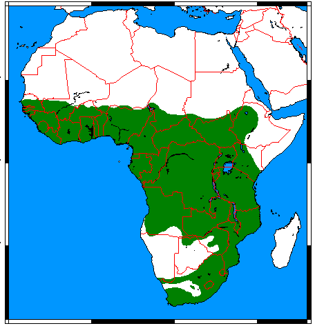
English: Range map for Marsh Mongoose (Atilax paludinosus), made by me with help of www.aquarius.geomar.de, Map depending on the range map at IUCN red list. |
| Petsa | |
| Gigikanan | Kaugalingong trabaho |
| Tagsulat | Udo Schröter |

|
This biogeographical map image could be re-created using vector graphics as an SVG file. This has several advantages; see Commons:Media for cleanup for more information. If an SVG form of this image is available, please upload it and afterwards replace this template with
{{vector version available|new image name}}.
It is recommended to name the SVG file “Atilax paludinosus range map.svg”—then the template Vector version available (or Vva) does not need the new image name parameter. |
Pagtugot
I, the copyright holder of this work, hereby publish it under the following licenses:
This file is licensed under the Creative Commons Attribution-Share Alike 3.0 Unported, 2.5 Generic, 2.0 Generic and 1.0 Generic license.
- Libre ka:
- sa pagsabwag – sa pagkopya, pag-apod-apod ug pagsabwag sa hinimo
- sa pag-remix – sa pag-adap sa binuhat
- Ubos sa mosunod nga mga kondisyon:
- atribusyon – Kinahanglan nimo nga hatagan ang angay nga kredito, maghatag usa ka link sa lisensya, ug ipakita kung adunay mga pagbag-o. Mahimo nimo kini buhaton sa bisan unsang makatarunganon nga paagi, apan dili sa bisan unsang paagi nga nagsugyot nga gi-endorso ka sa licensor o ang imong paggamit.
- share parehas – Kung imong gi-remix, gibag-o, o gibase sa materyal, kinahanglan nimo nga iapod-apod ang imong mga kontribusyon sa ilawom sa parehas o katugma nga lisensya sama sa orihinal.

|
Gitugot ang pagkopya, pag-apud-apod o/ug pag-usab ning maong dokumento ubos sa mga termino sa GNU Free Documentation License, Version 1.2 o mas bag-ong bersiyon nga gimantala sa Free Software Foundation; nga walay Invariant Sections, walay Front-Cover Texts, ug walay Back-Cover Texts. Ang kopya sa lisensiya gilakip sa bahin nga giulohang GNU Free Documentation License. |
You may select the license of your choice.
Kaagi sa payl
I-klik ang petsa/oras aron makit-an ang hulagway sa payl niadtong panahona.
| Petsa/Takna | Thumbnail | Mga dimensyon | Tiggamit | Komento | |
|---|---|---|---|---|---|
| kasamtangan | 01:07, 18 Marso 2018 | | 456 × 473 (18 KB) | Maphobbyist | Border updates: South Sudan, Eritrea and Lebanon added, Yemen united, the former Neutral Zone and Waalvisbai removed, and all border gaps filled. |
| 22:51, 16 Marso 2018 |  | 333 × 363 (14 KB) | Maphobbyist | South Sudan border | |
| 18:30, 28 Hulyo 2011 |  | 294 × 341 (19 KB) | Craig Pemberton | Crop to original size. | |
| 18:30, 28 Hulyo 2011 |  | 379 × 450 (25 KB) | Craig Pemberton | Normalize with other range maps for eventual combination in parent taxa. | |
| 13:50, 24 Abril 2009 |  | 456 × 473 (20 KB) | Nordelch | {{Information |Description={{en|1=Range map for Marsh Mongoose (''Atilax paludinosus''), made by me with help of [http://www.aquarius.geomar.de/omc_intro.html www.aquarius.geomar.de], Map depending on the [http://www.iucnredlist.org/details/41590 range ma |
Mga paggamit sa payl
Ang mosunod nga mga panid misumpay niining payl:
Global nga paggamit sa payl
Kining ubang wiki naggamit ning maong payl:
- Paggamit sa af.wikipedia.org
- Paggamit sa ar.wikipedia.org
- Paggamit sa arz.wikipedia.org
- Paggamit sa avk.wikipedia.org
- Paggamit sa azb.wikipedia.org
- Paggamit sa bg.wikipedia.org
- Paggamit sa br.wikipedia.org
- Paggamit sa ca.wikipedia.org
- Paggamit sa de.wikipedia.org
- Paggamit sa el.wikipedia.org
- Paggamit sa en.wikipedia.org
- Paggamit sa es.wikipedia.org
- Paggamit sa eu.wikipedia.org
- Paggamit sa fa.wikipedia.org
- Paggamit sa fr.wikipedia.org
- Paggamit sa he.wikipedia.org
- Paggamit sa hu.wikipedia.org
- Paggamit sa id.wikipedia.org
- Paggamit sa it.wikipedia.org
- Paggamit sa ko.wikipedia.org
- Paggamit sa mhr.wikipedia.org
- Paggamit sa pl.wikipedia.org
- Paggamit sa pnb.wikipedia.org
- Paggamit sa ru.wikipedia.org
- Paggamit sa sq.wikipedia.org
- Paggamit sa sv.wikipedia.org
- Paggamit sa tr.wikipedia.org
- Paggamit sa uk.wikipedia.org
- Paggamit sa vi.wikipedia.org
- Paggamit sa www.wikidata.org
- Paggamit sa zh.wikipedia.org