Payl:Australia relief map.jpg

Gidak-on ning maong paunang tan-aw: 668 x 600 ka mga piksel. Uban pang mga resoluyon: 267 x 240 ka mga piksel | 534 x 480 ka mga piksel | 855 x 768 ka mga piksel | 1,140 x 1,024 ka mga piksel | 1,336 x 1,200 ka mga piksel.
Tibuok resolusyon (1,336 × 1,200 pixels, size sa payl: 366 KB, MIME type: image/jpeg)
Mubong sugid:
| Deskripsyon |
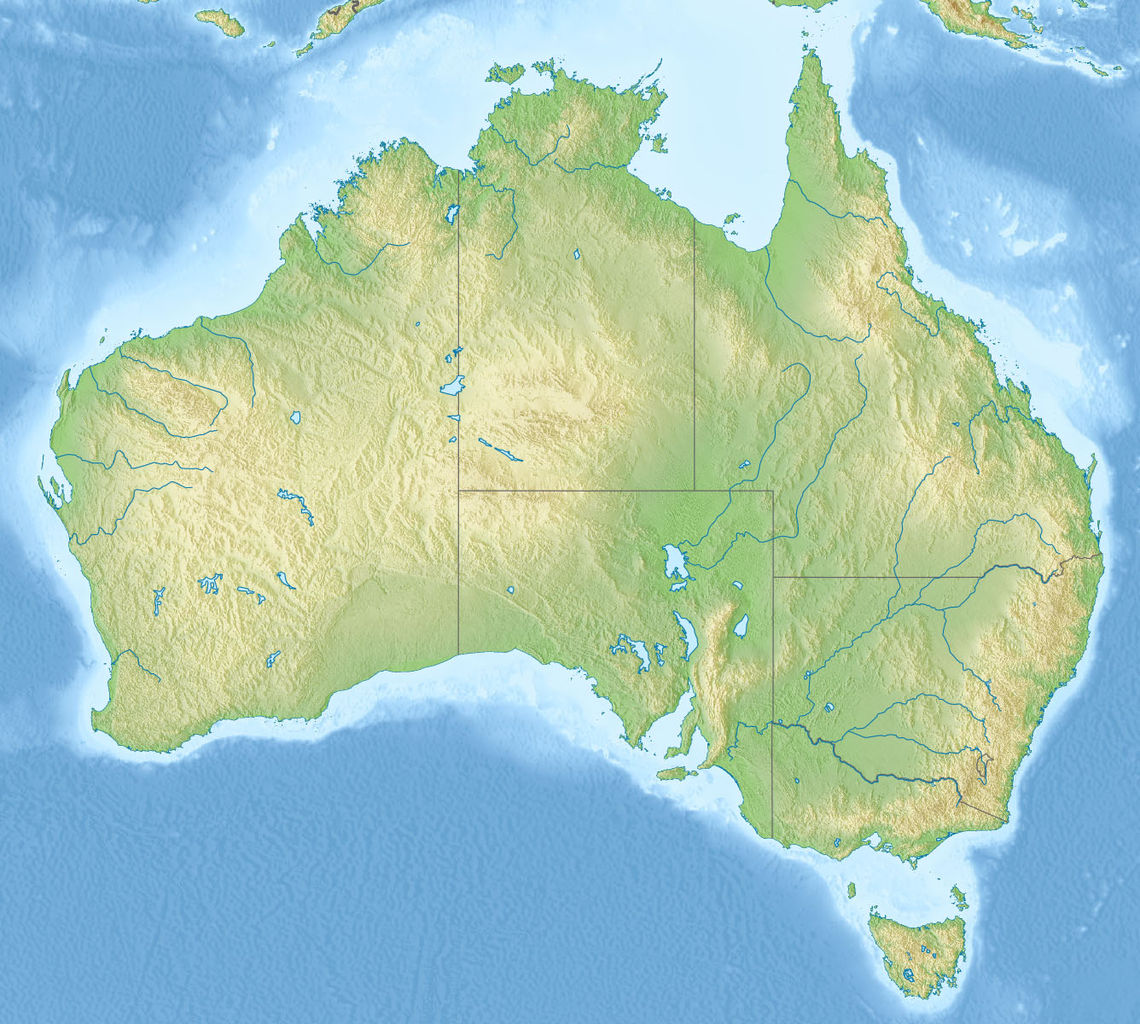
English: Relief map of Australia, including the borders of the states of the Commonwealth of Australia
Equirectangular projection, N/S stretching 110 %. Geographic limits of the map:
|
| Petsa | |
| Gigikanan |
|
| Tagsulat | |
| Other versions |
Derivative works of this file: Skylab reentry map.svg |

Pagtugot
This file is licensed under the Creative Commons Attribution-Share Alike 3.0 Unported license.
- Libre ka:
- sa pagsabwag – sa pagkopya, pag-apod-apod ug pagsabwag sa hinimo
- sa pag-remix – sa pag-adap sa binuhat
- Ubos sa mosunod nga mga kondisyon:
- atribusyon – Kinahanglan nimo nga hatagan ang angay nga kredito, maghatag usa ka link sa lisensya, ug ipakita kung adunay mga pagbag-o. Mahimo nimo kini buhaton sa bisan unsang makatarunganon nga paagi, apan dili sa bisan unsang paagi nga nagsugyot nga gi-endorso ka sa licensor o ang imong paggamit.
- share parehas – Kung imong gi-remix, gibag-o, o gibase sa materyal, kinahanglan nimo nga iapod-apod ang imong mga kontribusyon sa ilawom sa parehas o katugma nga lisensya sama sa orihinal.
Kaagi sa payl
I-klik ang petsa/oras aron makit-an ang hulagway sa payl niadtong panahona.
| Petsa/Takna | Thumbnail | Mga dimensyon | Tiggamit | Komento | |
|---|---|---|---|---|---|
| kasamtangan | 07:38, 14 Nobiyembre 2010 | | 1,336 × 1,200 (366 KB) | Виктор В | == {{int:filedesc}} == {{Information |Description={{en|Relief map of Australia}} Equirectangular projection, N/S stretching 110 %. Geographic limits of the map: * N: 9.0° S * S: 44.5° S * W: 111.5° E * E: 155.0° E |Source=* [[:File:A |
Mga paggamit sa payl
Ang mosunod nga 2 panid misumpay niining payl:
Global nga paggamit sa payl
Kining ubang wiki naggamit ning maong payl:
- Paggamit sa ab.wikipedia.org
- Paggamit sa als.wikipedia.org
- Paggamit sa am.wikipedia.org
- Paggamit sa ar.wikipedia.org
- Paggamit sa arz.wikipedia.org
- Paggamit sa ast.wikipedia.org
- Paggamit sa as.wikipedia.org
- Paggamit sa azb.wikipedia.org
- Paggamit sa az.wikipedia.org
- Böyük Suayırıcı sıra dağları
- Liverpul (dağ)
- Böyük Viktoriya səhrası
- Tasman dənizi
- Timor dənizi
- Eyr
- Uluru
- Hiller gölü
- Kakadu Milli Parkı
- Uluru–Kata-Tyuta Milli Parkı
- Purnululu Milli Parkı
- Şablon:Yer xəritəsi Avstraliya
- Freyzer (ada)
- Mərcan dənizi
- Kostyuşko (dağ)
- Bass boğazı
- Karpentariya körfəzi
- Spenser körfəzi
- Torres boğazı
- Dundas boğazı
- Tasman yarımadası
- Yanakie bərzəxi
- D'Antrkasto boğazı
- Undara Vulkanik Milli Parkı
- Kalbarri Milli Parkı
- Böyük Avstraliya körfəzi
- Torrens gölü
- Melvill (ada, Avstraliya)
- Bayron burnu
- York burnu (Avstraliya)
- Saut-Poynt
- Stip-Poynt burnu
- Böyük Qumlu səhra
- Kiçik Qumlu səhra
View more global usage of this file.