Payl:Babylone 1.PNG

Gidak-on ning maong paunang tan-aw: 800 x 559 ka mga piksel. Uban pang mga resoluyon: 320 x 224 ka mga piksel | 640 x 447 ka mga piksel | 982 x 686 ka mga piksel.
Tibuok resolusyon (982 × 686 pixels, size sa payl: 960 KB, MIME type: image/png)
| Deskripsyon |
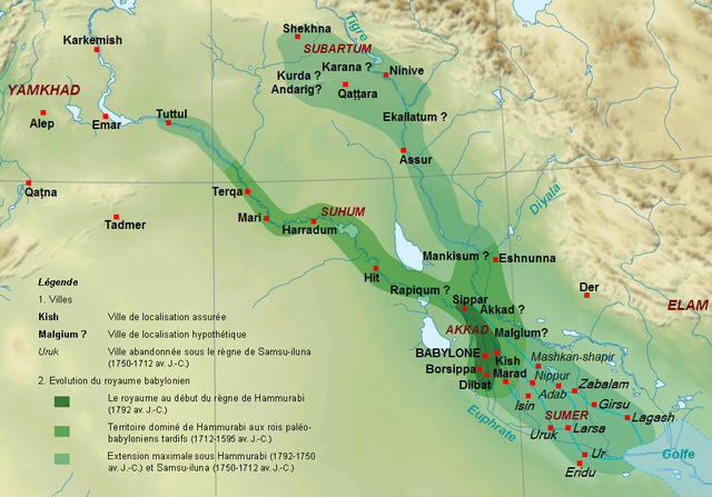
English: Map of the kingdom of the First Dynasty of Babylon from the beginning of the reign of Hammurabi (1792-1750 BC according to middle chronology) to the fall of Babylon in 1595 BC. The maximal extension of the kingdom under the reigns of Hammrabi and his son Samsu-iluna includes cities that have been taken by those kings, but probably dominated at best a few years, like Tuttul, Nineveh and Shekhna. The domination of Terqa by the successors of Samsu-iluna is probable because of some of them appear in the name years of tablets excavated there (Ammi-saduqa, Samsu-ditana). Français : Carte du royaume de la Première dynastie de Babylone depuis le début du règne de Hammurabi (1792-1750 av. J.-C. selon la chronologie moyenne) jusqu'à la chute de Babylone en 1595. L'extension maximale du royaume sous les règnes de Hammurabi et Samsu-iluna inclut des villes qui ont été dominées au mieux quelques années comme Tuttul, Ninive ou Shekhna. La domination de Terqa sous les successeurs de Samsu-iluna est probable du fait de l'utilisation du nom de certains d'entre eux pour dater des tablettes exhumées sur ce site (Ammi-saduqa, Samsu-ditana). |
| Petsa | (UTC) |
| Gigikanan | |
| Tagsulat |
|
| Other versions |
 |
| This is a retouched picture, which means that it has been digitally altered from its original version. Modifications: Extension du royaume, villes, légende.. The original can be viewed here: Near East topographic map-blank.svg:
|
I, the copyright holder of this work, hereby publish it under the following licenses:
This file is licensed under the Creative Commons Attribution-Share Alike 3.0 Unported, 2.5 Generic, 2.0 Generic and 1.0 Generic license.
- Libre ka:
- sa pagsabwag – sa pagkopya, pag-apod-apod ug pagsabwag sa hinimo
- sa pag-remix – sa pag-adap sa binuhat
- Ubos sa mosunod nga mga kondisyon:
- atribusyon – Kinahanglan nimo nga hatagan ang angay nga kredito, maghatag usa ka link sa lisensya, ug ipakita kung adunay mga pagbag-o. Mahimo nimo kini buhaton sa bisan unsang makatarunganon nga paagi, apan dili sa bisan unsang paagi nga nagsugyot nga gi-endorso ka sa licensor o ang imong paggamit.
- share parehas – Kung imong gi-remix, gibag-o, o gibase sa materyal, kinahanglan nimo nga iapod-apod ang imong mga kontribusyon sa ilawom sa parehas o katugma nga lisensya sama sa orihinal.

|
Gitugot ang pagkopya, pag-apud-apod o/ug pag-usab ning maong dokumento ubos sa mga termino sa GNU Free Documentation License, Version 1.2 o mas bag-ong bersiyon nga gimantala sa Free Software Foundation; nga walay Invariant Sections, walay Front-Cover Texts, ug walay Back-Cover Texts. Ang kopya sa lisensiya gilakip sa bahin nga giulohang GNU Free Documentation License. |
You may select the license of your choice.
Original upload log
This image is a derivative work of the following images:
- File:Near_East_topographic_map-blank.svg licensed with Cc-by-sa-3.0,2.5,2.0,1.0, GFDL
- 2009-08-18T18:31:37Z Sémhur 2425x1581 (2442670 Bytes) 3 - New try
- 2009-08-17T15:39:22Z Sémhur 2425x1581 (1815374 Bytes) 2 - With the background...
- 2009-08-17T15:37:36Z Sémhur 2425x1581 (2836 Bytes) {{Information |Description={{en|1=Blank physical map of the [[:en:Near East|Near East]]}} {{fr|1=Carte physique vierge du [[:fr:Proche-Orient|Proche-Orient]].}} |Source={{own}} |Author=[[User:Sémhur|Sémhur]] |Date=2008-08-1
Uploaded with derivativeFX
Kaagi sa payl
I-klik ang petsa/oras aron makit-an ang hulagway sa payl niadtong panahona.
| Petsa/Takna | Thumbnail | Mga dimensyon | Tiggamit | Komento | |
|---|---|---|---|---|---|
| kasamtangan | 16:16, 29 Septiyembre 2010 | | 982 × 686 (960 KB) | Zunkir | {{Information |Description={{en|1=Map of the kigdom of the First Dynasty of Babylon from the beginning of the reign of Hammurabi (1792-1750 BC according to middle chronology) to the fall of Babylon in 1595 BC. The maximal extension of the kigdom under the |
Mga paggamit sa payl
Ang mosunod nga mga panid misumpay niining payl:
Global nga paggamit sa payl
Kining ubang wiki naggamit ning maong payl:
- Paggamit sa am.wikipedia.org
- Paggamit sa ar.wikipedia.org
- Paggamit sa arz.wikipedia.org
- Paggamit sa bn.wikipedia.org
- Paggamit sa ca.wikipedia.org
- Paggamit sa cs.wikipedia.org
- Paggamit sa de.wikipedia.org
- Paggamit sa en.wikipedia.org
- Paggamit sa fa.wikipedia.org
- Paggamit sa fi.wikipedia.org
- Paggamit sa fr.wikipedia.org
- Antiquité
- XVIIIe siècle av. J.-C.
- Ninive
- Hammurabi
- Histoire de l'Irak
- Code de Hammurabi
- Samsu-iluna
- Liste des souverains de Babylone
- Histoire de la Mésopotamie
- Babylone (civilisation)
- Proche-Orient ancien
- Utilisateur:Zunkir/POA autres
- Utilisateur:Zunkir/cartothèque
- Première dynastie de Babylone
- Littérature irakienne
- Paggamit sa id.wikipedia.org
- Paggamit sa incubator.wikimedia.org
- Paggamit sa ja.wikipedia.org
- Paggamit sa ko.wikipedia.org
- Paggamit sa la.wikipedia.org
View more global usage of this file.