Payl:Badghis districts.png

Gidak-on ning maong paunang tan-aw: 800 x 548 ka mga piksel. Uban pang mga resoluyon: 320 x 219 ka mga piksel | 640 x 439 ka mga piksel | 960 x 658 ka mga piksel.
Tibuok resolusyon (960 × 658 pixels, size sa payl: 16 KB, MIME type: image/png)

|
This map image could be re-created using vector graphics as an SVG file. This has several advantages; see Commons:Media for cleanup for more information. If an SVG form of this image is available, please upload it and afterwards replace this template with
{{vector version available|new image name}}.
It is recommended to name the SVG file “Badghis districts.svg”—then the template Vector version available (or Vva) does not need the new image name parameter. |
Mubong sugid:
| Deskripsyon |
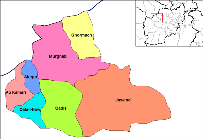
English: Map of the districts of Badghis province of Afghanistan. Created by Rarelibra 19:19, 29 March 2007 (UTC) for public domain use, using MapInfo Professional v8.5 and various mapping resources. |
| Petsa | 29 Marso 2007 (original upload date) |
| Gigikanan | No machine-readable source provided. Own work assumed (based on copyright claims). |
| Tagsulat | No machine-readable author provided. Rarelibra assumed (based on copyright claims). |
Pagtugot
| I, the copyright holder of this work, release this work into the public domain. This applies worldwide. In some countries this may not be legally possible; if so: I grant anyone the right to use this work for any purpose, without any conditions, unless such conditions are required by law. |
Kaagi sa payl
I-klik ang petsa/oras aron makit-an ang hulagway sa payl niadtong panahona.
| Petsa/Takna | Thumbnail | Mga dimensyon | Tiggamit | Komento | |
|---|---|---|---|---|---|
| kasamtangan | 13:39, 15 Pebrero 2024 | | 960 × 658 (16 KB) | User-duck | Cropped 9 % horizontally, 19 % vertically using CropTool with lossless mode. |
| 19:19, 29 Marso 2007 |  | 1,056 × 816 (25 KB) | Rarelibra | Map of the districts of Badghis province of Afghanistan. Created by ~~~~ for public domain use, using MapInfo Professional v8.5 and various mapping resources. |
Mga paggamit sa payl
Ang mosunod nga mga panid misumpay niining payl:
Global nga paggamit sa payl
Kining ubang wiki naggamit ning maong payl:
- Paggamit sa ar.wikipedia.org
- Paggamit sa az.wikipedia.org
- Paggamit sa bn.wikipedia.org
- Paggamit sa ca.wikipedia.org
- Paggamit sa ckb.wikipedia.org
- Paggamit sa de.wikipedia.org
- Paggamit sa en.wikipedia.org
- Paggamit sa es.wikipedia.org
- Paggamit sa fa.wikipedia.org
- Paggamit sa fr.wikipedia.org
- Paggamit sa he.wikipedia.org
- Paggamit sa id.wikipedia.org
- Paggamit sa incubator.wikimedia.org
- Paggamit sa it.wikipedia.org
- Paggamit sa ja.wikipedia.org
- Paggamit sa lt.wikipedia.org
- Paggamit sa ml.wikipedia.org
- Paggamit sa mn.wikipedia.org
- Paggamit sa ms.wikipedia.org
- Paggamit sa nl.wikipedia.org
- Paggamit sa no.wikipedia.org
- Paggamit sa pl.wikipedia.org
- Paggamit sa pnb.wikipedia.org
- Paggamit sa ps.wikipedia.org
- Paggamit sa pt.wikipedia.org
- Paggamit sa ru.wikipedia.org
- Paggamit sa sco.wikipedia.org
- Paggamit sa sd.wikipedia.org
- Paggamit sa simple.wikipedia.org
- Paggamit sa sk.wikipedia.org
- Paggamit sa ta.wikipedia.org
- Paggamit sa th.wikipedia.org
- Paggamit sa tr.wikipedia.org
- Paggamit sa uk.wikipedia.org
- Paggamit sa ur.wikipedia.org
- Paggamit sa uz.wikipedia.org
- Paggamit sa vi.wikipedia.org
View more global usage of this file.