Payl:Bassas da India atoll map-fr.png
Gidak-on ning maong paunang tan-aw: 650 x 600 ka mga piksel. Uban pang mga resoluyon: 260 x 240 ka mga piksel | 520 x 480 ka mga piksel | 832 x 768 ka mga piksel | 1,110 x 1,024 ka mga piksel | 1,555 x 1,435 ka mga piksel.
Tibuok resolusyon (1,555 × 1,435 pixels, size sa payl: 371 KB, MIME type: image/png)
Mubong sugid:
| Camera location | | View this and other nearby images on: OpenStreetMap |
|---|
| Deskripsyon |
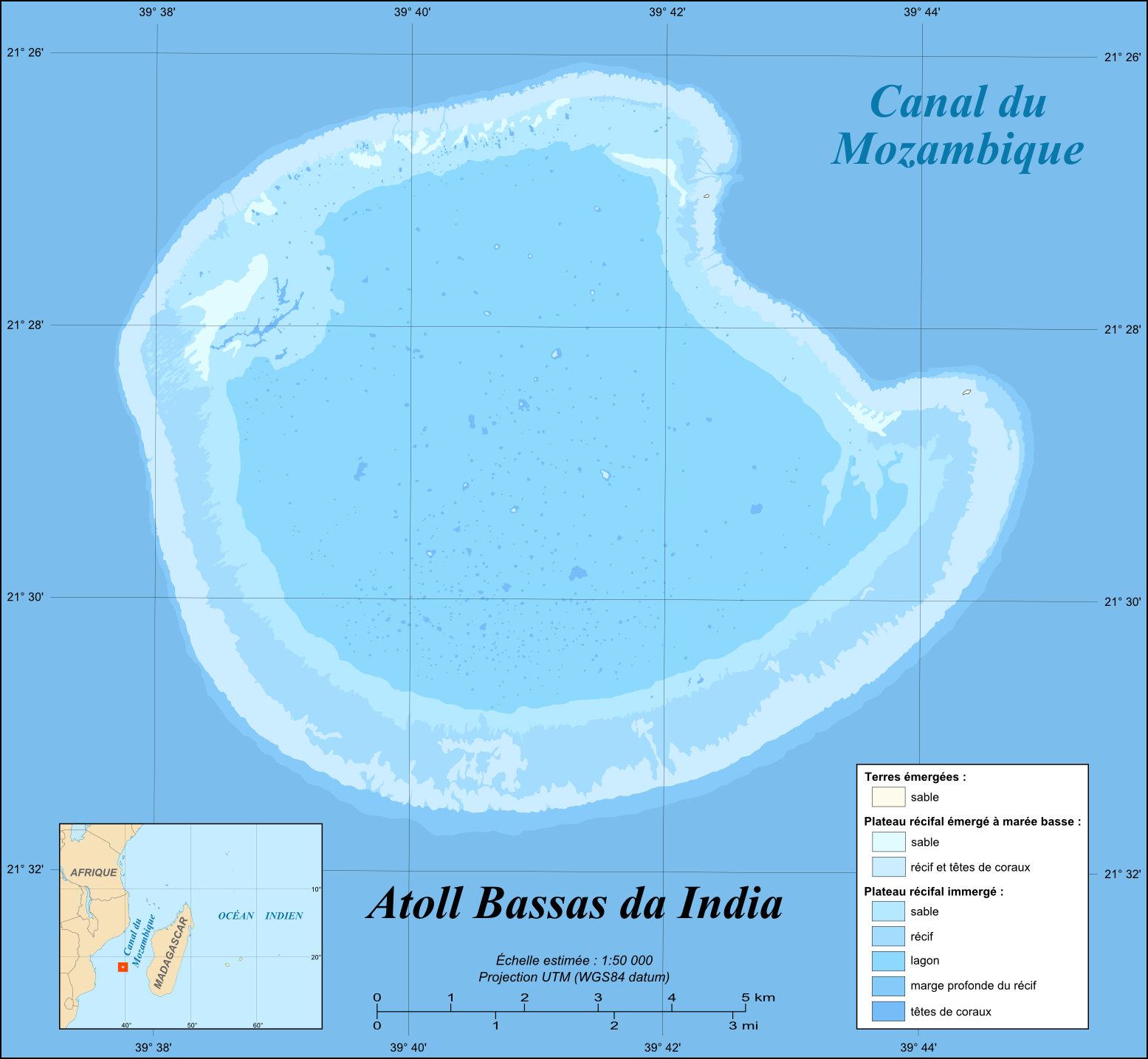
English: Map in French of the French atoll of Bassas da India, Scattered islands in the Indian Ocean.
Français : Carte en français de l'atoll français de Bassas da India, Îles Éparses.
|
||
| Petsa | |||
| Gigikanan |
Own work |
||
| Tagsulat | Eric Gaba (Sting - fr:Sting) | ||
| Pagtugot (Paggamit pag-usab niini nga file) |
|
||
| Other versions |
[]
|


Pagtugot
I, the copyright holder of this work, hereby publish it under the following licenses:

|
Gitugot ang pagkopya, pag-apud-apod o/ug pag-usab ning maong dokumento ubos sa mga termino sa GNU Free Documentation License, Version 1.2 o mas bag-ong bersiyon nga gimantala sa Free Software Foundation; nga walay Invariant Sections, walay Front-Cover Texts, ug walay Back-Cover Texts. Ang kopya sa lisensiya gilakip sa bahin nga giulohang GNU Free Documentation License. |
This file is licensed under the Creative Commons Attribution-Share Alike 4.0 International, 3.0 Unported, 2.5 Generic, 2.0 Generic and 1.0 Generic license.
- Libre ka:
- sa pagsabwag – sa pagkopya, pag-apod-apod ug pagsabwag sa hinimo
- sa pag-remix – sa pag-adap sa binuhat
- Ubos sa mosunod nga mga kondisyon:
- atribusyon – Kinahanglan nimo nga hatagan ang angay nga kredito, maghatag usa ka link sa lisensya, ug ipakita kung adunay mga pagbag-o. Mahimo nimo kini buhaton sa bisan unsang makatarunganon nga paagi, apan dili sa bisan unsang paagi nga nagsugyot nga gi-endorso ka sa licensor o ang imong paggamit.
- share parehas – Kung imong gi-remix, gibag-o, o gibase sa materyal, kinahanglan nimo nga iapod-apod ang imong mga kontribusyon sa ilawom sa parehas o katugma nga lisensya sama sa orihinal.
You may select the license of your choice.
Kaagi sa payl
I-klik ang petsa/oras aron makit-an ang hulagway sa payl niadtong panahona.
| Petsa/Takna | Thumbnail | Mga dimensyon | Tiggamit | Komento | |
|---|---|---|---|---|---|
| kasamtangan | 13:51, 19 Hulyo 2010 | | 1,555 × 1,435 (371 KB) | Sting | Color profile |
| 15:30, 17 Nobiyembre 2009 |  | 1,555 × 1,435 (373 KB) | Sting | Embedded sRGB profile | |
| 17:59, 6 Hunyo 2008 |  | 1,555 × 1,435 (329 KB) | Sting | Inkscape export bug correction | |
| 17:40, 6 Hunyo 2008 |  | 1,555 × 1,435 (331 KB) | Sting | == Summary == {{Location|21|28|39|S|39|41|07|E|scale:100000}} <br/>{{Information |Description={{en|Map in French of the French atoll of Bassas da India, [[:en:Scattered islands in the Indian Ocean|Scattered islands in the Indian Oc |
Mga paggamit sa payl
Ang mosunod nga mga panid misumpay niining payl:
Global nga paggamit sa payl
Kining ubang wiki naggamit ning maong payl:
- Paggamit sa ar.wikipedia.org
- Paggamit sa ast.wikipedia.org
- Paggamit sa ca.wikipedia.org
- Paggamit sa en.wikipedia.org
- Paggamit sa eo.wikipedia.org
- Paggamit sa es.wikipedia.org
- Paggamit sa eu.wikipedia.org
- Paggamit sa fr.wikipedia.org
- Paggamit sa mg.wikipedia.org
- Paggamit sa mk.wikipedia.org
- Paggamit sa pl.wikipedia.org
- Paggamit sa pt.wikipedia.org
- Paggamit sa ro.wikipedia.org
- Paggamit sa sq.wikipedia.org
- Paggamit sa sv.wikipedia.org
- Paggamit sa tr.wikipedia.org
- Paggamit sa uk.wikipedia.org
- Paggamit sa ur.wikipedia.org
- Paggamit sa vi.wikipedia.org
- Paggamit sa www.wikidata.org
- Paggamit sa zh.wikipedia.org