Payl:Basse Mesopotamie PB.PNG
Walay mas taas nga resolusyon.
Basse_Mesopotamie_PB.PNG (440 × 393 pixels, size sa payl: 157 KB, MIME type: image/png)
| Deskripsyon |
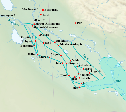
English: Location map of the main cities of Lower Mesopotamia during the Old Babylonian period (2004-1595 BC). With the approximate course of the rivers and the ancient shoreline of the Gulf. Français : Carte de localisation des principales villes de la Basse Mésopotamie durant la période paléo-babylonienne (2004-1595 av. J.-C.). Avec le tracé approximatif des fleuves et l'ancien trait de côte du Golfe. |
| Petsa | (UTC) |
| Gigikanan | |
| Tagsulat |
|
| This is a retouched picture, which means that it has been digitally altered from its original version. Modifications: Ajout des villes, du tracé des fleuves antiques et du trait de côte du Golfe.. The original can be viewed here: Near East topographic map-blank.svg:
|
I, the copyright holder of this work, hereby publish it under the following licenses:
This file is licensed under the Creative Commons Attribution-Share Alike 3.0 Unported, 2.5 Generic, 2.0 Generic and 1.0 Generic license.
- Libre ka:
- sa pagsabwag – sa pagkopya, pag-apod-apod ug pagsabwag sa hinimo
- sa pag-remix – sa pag-adap sa binuhat
- Ubos sa mosunod nga mga kondisyon:
- atribusyon – Kinahanglan nimo nga hatagan ang angay nga kredito, maghatag usa ka link sa lisensya, ug ipakita kung adunay mga pagbag-o. Mahimo nimo kini buhaton sa bisan unsang makatarunganon nga paagi, apan dili sa bisan unsang paagi nga nagsugyot nga gi-endorso ka sa licensor o ang imong paggamit.
- share parehas – Kung imong gi-remix, gibag-o, o gibase sa materyal, kinahanglan nimo nga iapod-apod ang imong mga kontribusyon sa ilawom sa parehas o katugma nga lisensya sama sa orihinal.

|
Gitugot ang pagkopya, pag-apud-apod o/ug pag-usab ning maong dokumento ubos sa mga termino sa GNU Free Documentation License, Version 1.2 o mas bag-ong bersiyon nga gimantala sa Free Software Foundation; nga walay Invariant Sections, walay Front-Cover Texts, ug walay Back-Cover Texts. Ang kopya sa lisensiya gilakip sa bahin nga giulohang GNU Free Documentation License. |
You may select the license of your choice.
Original upload log
This image is a derivative work of the following images:
- File:Near_East_topographic_map-blank.svg licensed with Cc-by-sa-3.0,2.5,2.0,1.0, GFDL
- 2009-08-18T18:31:37Z Sémhur 2425x1581 (2442670 Bytes) 3 - New try
- 2009-08-17T15:39:22Z Sémhur 2425x1581 (1815374 Bytes) 2 - With the background...
- 2009-08-17T15:37:36Z Sémhur 2425x1581 (2836 Bytes) {{Information |Description={{en|1=Blank physical map of the [[:en:Near East|Near East]]}} {{fr|1=Carte physique vierge du [[:fr:Proche-Orient|Proche-Orient]].}} |Source={{own}} |Author=[[User:Sémhur|Sémhur]] |Date=2008-08-1
Uploaded with derivativeFX
Kaagi sa payl
I-klik ang petsa/oras aron makit-an ang hulagway sa payl niadtong panahona.
| Petsa/Takna | Thumbnail | Mga dimensyon | Tiggamit | Komento | |
|---|---|---|---|---|---|
| kasamtangan | 10:21, 26 Pebrero 2023 | | 440 × 393 (157 KB) | Zunkir | opacité, cours d'eau, villes |
| 21:02, 10 Disyembre 2017 |  | 1,026 × 736 (588 KB) | Bulldoc | aggiunta Umma ed il terreno della Guedemma, causa della guerra con Lagash | |
| 01:17, 13 Enero 2017 |  | 1,026 × 736 (814 KB) | Kindattu2004 | Cities of Kisurra and Kutalla added | |
| 16:59, 28 Septiyembre 2010 |  | 1,026 × 736 (826 KB) | Zunkir | {{Information |Description={{en|1=Location map of the main cities of Lower Mesopotamia during the paleo-babylonian period (2004-1595 BC). With the approximate course of the rivers and the ancient shoreline of the Gulf.}} {{fr|1=Carte de localisation des p |
Mga paggamit sa payl
Ang mosunod nga mga panid misumpay niining payl:
Global nga paggamit sa payl
Kining ubang wiki naggamit ning maong payl:
- Paggamit sa ar.wikipedia.org
- Paggamit sa arz.wikipedia.org
- Paggamit sa ca.wikipedia.org
- Paggamit sa en.wikipedia.org
- Paggamit sa es.wikipedia.org
- Paggamit sa fr.wikipedia.org
- Paggamit sa it.wikipedia.org
- Paggamit sa pl.wikipedia.org
View more global usage of this file.