Payl:Belize location map.svg

Size of this PNG preview of this SVG file: 432 x 599 ka mga piksel. Uban pang mga resoluyon: 173 x 240 ka mga piksel | 346 x 480 ka mga piksel | 554 x 768 ka mga piksel | 739 x 1,024 ka mga piksel | 1,478 x 2,048 ka mga piksel | 788 x 1,092 ka mga piksel.
Tibuok resolusyon (SVG nga payl, nominally 788 × 1,092 pixels, size sa payl: 106 KB)
Mubong sugid:
| Deskripsyon |
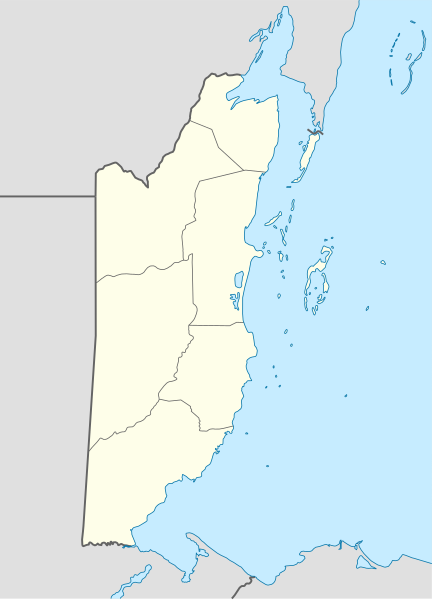
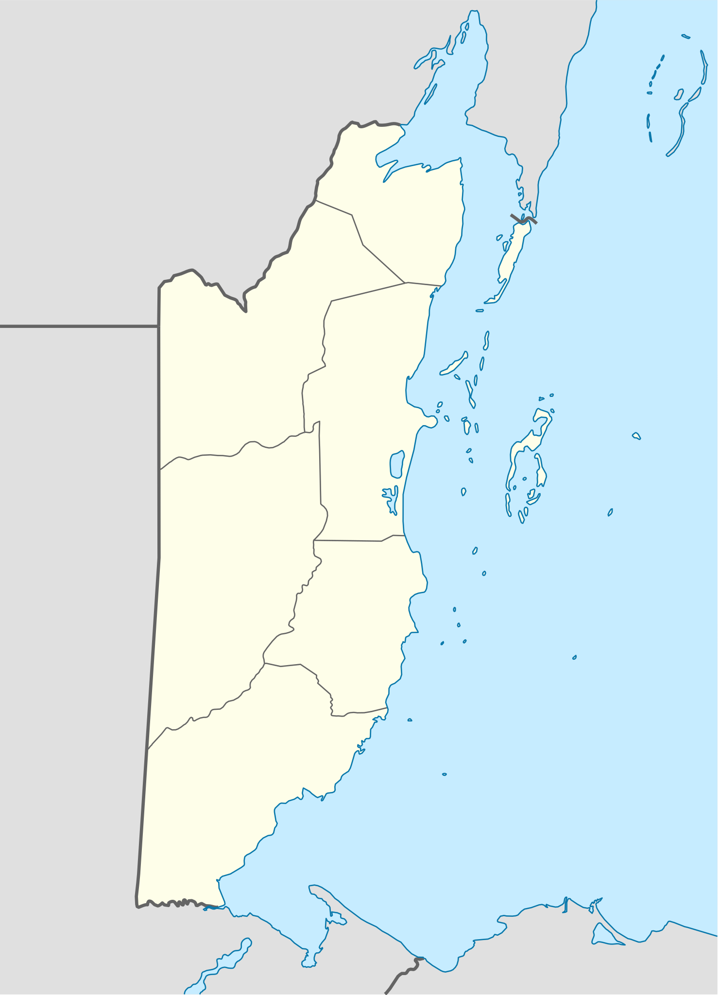
Deutsch: Positionskarte von Belize
Quadratische Plattkarte, N-S-Streckung 105 %. Geographische Begrenzung der Karte:
English: Location map of Belize
|
||||||||||||
| Petsa | |||||||||||||
| Gigikanan | Own work using: United States National Imagery and Mapping Agency data | ||||||||||||
| Tagsulat | NordNordWest | ||||||||||||
| SVG genesis |
|
||||||||||||

Pagtugot
NordNordWest, the copyright holder of this work, hereby publishes it under the following licenses:

|
Gitugot ang pagkopya, pag-apud-apod o/ug pag-usab ning maong dokumento ubos sa mga termino sa GNU Free Documentation License, Version 1.2 o mas bag-ong bersiyon nga gimantala sa Free Software Foundation; nga walay Invariant Sections, walay Front-Cover Texts, ug walay Back-Cover Texts. Ang kopya sa lisensiya gilakip sa bahin nga giulohang GNU Free Documentation License. |
This file is licensed under the Creative Commons Attribution-Share Alike 3.0 Unported license.
Attribution: NordNordWest
- Libre ka:
- sa pagsabwag – sa pagkopya, pag-apod-apod ug pagsabwag sa hinimo
- sa pag-remix – sa pag-adap sa binuhat
- Ubos sa mosunod nga mga kondisyon:
- atribusyon – Kinahanglan nimo nga hatagan ang angay nga kredito, maghatag usa ka link sa lisensya, ug ipakita kung adunay mga pagbag-o. Mahimo nimo kini buhaton sa bisan unsang makatarunganon nga paagi, apan dili sa bisan unsang paagi nga nagsugyot nga gi-endorso ka sa licensor o ang imong paggamit.
- share parehas – Kung imong gi-remix, gibag-o, o gibase sa materyal, kinahanglan nimo nga iapod-apod ang imong mga kontribusyon sa ilawom sa parehas o katugma nga lisensya sama sa orihinal.
You may select the license of your choice.
Kaagi sa payl
I-klik ang petsa/oras aron makit-an ang hulagway sa payl niadtong panahona.
| Petsa/Takna | Thumbnail | Mga dimensyon | Tiggamit | Komento | |
|---|---|---|---|---|---|
| kasamtangan | 07:15, 10 Disyembre 2016 | | 788 × 1,092 (106 KB) | Kaldari | Fixing Cayo District border per http://www.elections.gov.bz/modules/wfdownloads/visit.php?cid=109&lid=213 |
| 19:37, 4 Septiyembre 2008 |  | 788 × 1,092 (106 KB) | NordNordWest | size correction | |
| 19:34, 4 Septiyembre 2008 |  | 630 × 874 (106 KB) | NordNordWest | {{Information |Description= {{de|Positionskarte von Belize}} Quadratische Plattkarte, N-S-Streckung 105 %. Geographische Begrenzung der Karte: * N: 18.9° N * S: 15.6° N * W: 89.7° W * O: 87.2° W {{en|Location map of [[:en:Belize|Belize] |
Mga paggamit sa payl
More than 100 pages use this file. The following list shows the first 100 pages that use this file only. A full list is available.
- Alligator Point
- Ambergris Cay
- Arroyo Azul
- Belize (pagklaro)
- Big Pond
- Bird Cay
- Black Rock
- Blackwater Creek
- Buena Vista
- Calabash Cay
- Cat Cay
- Cerrito
- Channel Cay
- Cockroach Cay
- Cocoa Plum Cay
- Coconut Point
- Cross Cay
- Deadman’s Cays
- Deep Creek
- Douglas
- Eastern Channel
- Elbow Cays
- Esperanza (pagklaro)
- False Point
- Haulover Creek
- Iguana Cay
- John Creek
- Laguna Azul
- Laguna Seca
- Lark Rock
- Laughing Bird Cay
- Long Cay
- Low Cay
- Mahogany Creek
- Main Channel
- Man of War Cay
- Middle Cay
- Middle Ground
- Monkey River
- Mountain Cow Creek
- North Fork
- Pelican Cay
- Pelican Cays
- Pico Victoria
- Pomona
- Pueblo Nuevo
- Puhi
- Punta Gallows
- Punta Gorda
- Punta Negra
- Red Bank Creek
- Red Creek
- Red Rock
- Reef Point
- Richardson Peak
- Rio Blanco
- Rio Frio
- Rio Grande
- Rio Hondo
- Robinson Point
- Rock Point
- Rocky Point
- Round Cay
- Río Azul
- Río Blanco
- Río Hondo
- Río Nuevo
- Río San Pedro
- Río Santa María
- Saddle Cay
- Saddle Hill
- Salt Creek
- Samphire Cay
- San Antonio
- San Felipe
- San Ignacio
- San Jose (pagklaro)
- San Pedro (pagklaro)
- Sand Point
- Sandy Creek
- Santa Ana
- Santa Elena
- Santa Rita
- Sapodilla Creek
- Snake Creek
- Snake Point
- Soldier Cay
- South Cay
- Spanish Cay
- Spanish Creek
- Spanish Point
- Table Rock
- The Bight
- The Bluff
- Toledo
- Twin Cays
- Victoria Creek
- Water Cay
- Western District
- White Hill
View more links to this file.
Global nga paggamit sa payl
Kining ubang wiki naggamit ning maong payl:
- Paggamit sa af.wikipedia.org
- Paggamit sa an.wikipedia.org
- Paggamit sa ar.wikipedia.org
- Paggamit sa ast.wikipedia.org
- Ciudá de Belize
- Belmopán
- Gran furacu azul
- Módulu:Mapa de llocalización/datos/Belize
- Módulu:Mapa de llocalización/datos/Belize/usu
- Aeropuertu de Corozal
- Aeropuertu de Dangriga
- Aeropuertu de Placencia
- Aeropuertu de Punta Gorda
- Aeropuertu de San Pedro
- Pista d'Aterrizaxe Héctor Silva
- Puertu de Belize
- Puertu de Big Creek
- Paggamit sa az.wikipedia.org
- Paggamit sa ba.wikipedia.org
- Paggamit sa be-tarask.wikipedia.org
- Paggamit sa be.wikipedia.org
- Paggamit sa bg.wikipedia.org
- Paggamit sa bn.wikipedia.org
- Paggamit sa bs.wikipedia.org
- Paggamit sa ckb.wikipedia.org
- Paggamit sa cs.wikipedia.org
View more global usage of this file.