Payl:Blanco Bay.png

Tibuok resolusyon (1,140 × 745 pixels, size sa payl: 92 KB, MIME type: image/png)
Mubong sugid:
| Deskripsyon |
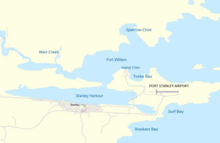
English: Map of the Port Stanley, Falklands area |
| Petsa | |
| Gigikanan | http://www.maps-for-free.com/ |
| Tagsulat | Modified by Dr. Blofeld |
| Pagtugot (Paggamit pag-usab niini nga file) |
http://www.maps-for-free.com/html/about.html |

|
File:Stanley and Stanley Harbour.svg is a vector version of this file. It should be used in place of this PNG file when not inferior.
File:Blanco Bay.png → File:Stanley and Stanley Harbour.svg
For more information, see Help:SVG. |
 |
|
|
File:Stanley - Port, airport and Yorke Bay.svg is a vector version of this file. It should be used in place of this PNG file when not inferior.
File:Blanco Bay.png → File:Stanley - Port, airport and Yorke Bay.svg
For more information, see Help:SVG. |
 |
Pagtugot
This screenshot either does not contain copyright-eligible parts or visuals of copyrighted software, or the author has released it under a free license (which should be indicated beneath this notice), and as such follows the licensing guidelines for screenshots of Wikimedia Commons. You may use it freely according to its particular license. Free software license:

|
This work is free software; you can redistribute it and/or modify it under the terms of the GNU General Public License as published by the Free Software Foundation; either version 2 of the License, or any later version. This work is distributed in the hope that it will be useful, but without any warranty; without even the implied warranty of merchantability or fitness for a particular purpose. See version 2 and version 3 of the GNU General Public License for more details. |
Note: if the screenshot shows any work that is not a direct result of the program code itself, such as a text or graphics that are not part of the program, the license for that work must be indicated separately.
- Libre ka:
- sa pagsabwag – sa pagkopya, pag-apod-apod ug pagsabwag sa hinimo
- sa pag-remix – sa pag-adap sa binuhat
- Ubos sa mosunod nga mga kondisyon:
- atribusyon – Kinahanglan nimo nga hatagan ang angay nga kredito, maghatag usa ka link sa lisensya, ug ipakita kung adunay mga pagbag-o. Mahimo nimo kini buhaton sa bisan unsang makatarunganon nga paagi, apan dili sa bisan unsang paagi nga nagsugyot nga gi-endorso ka sa licensor o ang imong paggamit.
Kaagi sa payl
I-klik ang petsa/oras aron makit-an ang hulagway sa payl niadtong panahona.
| Petsa/Takna | Thumbnail | Mga dimensyon | Tiggamit | Komento | |
|---|---|---|---|---|---|
| kasamtangan | 18:26, 4 Hunyo 2020 | | 1,140 × 745 (92 KB) | Hohum | Cartographic colours |
| 11:21, 20 Marso 2012 |  | 1,140 × 745 (2.43 MB) | Apcbg | Fixed toponymy. There is no 'Blanco Bay' in the Falklands toponymy, see the comprehensive [http://www.pcgn.org.uk/Falkland%20Islands-July2006.pdf relevant source]. The bay in question is 'Port William' ('Puerto Groussac' by Argentina). | |
| 11:22, 7 Disyembre 2011 |  | 1,140 × 745 (105 KB) | Blofeld Dr. | ||
| 11:13, 7 Disyembre 2011 |  | 1,140 × 745 (103 KB) | Blofeld Dr. | {{Information |Description ={{en|1=k}} |Source =k |Author =k |Date =k |Permission = |other_versions = }} |
Mga paggamit sa payl
Ang mosunod nga mga panid misumpay niining payl:
Global nga paggamit sa payl
Kining ubang wiki naggamit ning maong payl:
- Paggamit sa ast.wikipedia.org
- Paggamit sa bn.wikipedia.org
- Paggamit sa en.wikipedia.org
- Paggamit sa es.wikipedia.org
- Paggamit sa fa.wikipedia.org
- Paggamit sa fr.wikipedia.org
- Paggamit sa he.wikipedia.org
- Paggamit sa hu.wikipedia.org
- Paggamit sa id.wikipedia.org
- Paggamit sa incubator.wikimedia.org
- Paggamit sa io.wikipedia.org
- Paggamit sa ml.wikipedia.org
- Paggamit sa nn.wikipedia.org
- Paggamit sa pt.wikipedia.org
- Paggamit sa sco.wikipedia.org
- Paggamit sa sv.wikipedia.org
- Paggamit sa ta.wikipedia.org
- Paggamit sa th.wikipedia.org
- Paggamit sa www.wikidata.org
- Paggamit sa zh.wikipedia.org