Payl:Bow Lake beim Icefields Parkway.jpg

Gidak-on ning maong paunang tan-aw: 800 x 450 ka mga piksel. Uban pang mga resoluyon: 320 x 180 ka mga piksel | 640 x 360 ka mga piksel | 1,024 x 576 ka mga piksel | 1,280 x 720 ka mga piksel | 2,560 x 1,440 ka mga piksel | 4,820 x 2,711 ka mga piksel.
Tibuok resolusyon (4,820 × 2,711 pixels, size sa payl: 9.57 MB, MIME type: image/jpeg)
Mubong sugid:
| Deskripsyon |
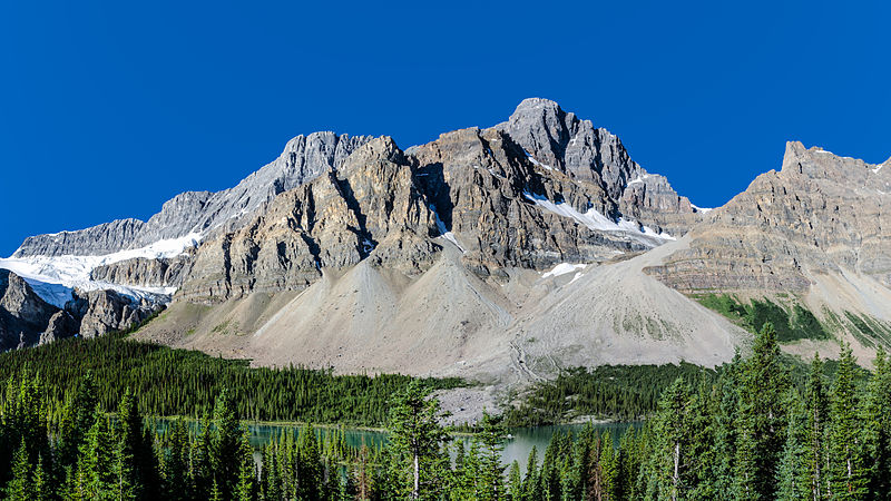
English: Bow Lake near Icefields Parkway and Crowfoot Mountain, Alberta, Canada Deutsch: Bow Lake beim Icefields Parkway und der Crowfoot Mountain, Alberta, Kanada Nederlands: Bow Lake nabij Icefields Parkway en Crowfoot Mountain in Alberta, Canada. |
| Petsa | |
| Gigikanan | Kaugalingong trabaho |
| Tagsulat | Florian Fuchs |
| Other versions |
 |
|
This image was selected as picture of the day on Wikimedia Commons for 11 November 2012. It was captioned as follows: English: Bow Lake near Icefields Parkway and Crowfoot Mountain, Alberta, Canada Other languages:
Deutsch: Der Bow Lake beim Icefields Parkway und Crowfoot-Mountain im Banff-Nationalpark in der kanadischen Provinz Alberta English: Bow Lake near Icefields Parkway and Crowfoot Mountain, Alberta, Canada Italiano: Bow Lake e Crowfoot Mountain vicino alla strada panoramica Icefields Parkway, Alberta, Canada Русский: Озеро Боу и гора Кроуфут, Альберта, Канада 中文: 冰原公路附近的弓湖。 |
| Camera location | | View this and other nearby images on: OpenStreetMap |
|---|
Pagtugot
I, the copyright holder of this work, hereby publish it under the following license:
This file is licensed under the Creative Commons Attribution 3.0 Unported license.
Attribution: Florian Fuchs
- Libre ka:
- sa pagsabwag – sa pagkopya, pag-apod-apod ug pagsabwag sa hinimo
- sa pag-remix – sa pag-adap sa binuhat
- Ubos sa mosunod nga mga kondisyon:
- atribusyon – Kinahanglan nimo nga hatagan ang angay nga kredito, maghatag usa ka link sa lisensya, ug ipakita kung adunay mga pagbag-o. Mahimo nimo kini buhaton sa bisan unsang makatarunganon nga paagi, apan dili sa bisan unsang paagi nga nagsugyot nga gi-endorso ka sa licensor o ang imong paggamit.
Kaagi sa payl
I-klik ang petsa/oras aron makit-an ang hulagway sa payl niadtong panahona.
| Petsa/Takna | Thumbnail | Mga dimensyon | Tiggamit | Komento | |
|---|---|---|---|---|---|
| kasamtangan | 04:13, 13 Oktubre 2012 | | 4,820 × 2,711 (9.57 MB) | Florian Fuchs | corrected some distortion |
| 01:32, 9 Oktubre 2012 |  | 4,820 × 2,711 (10.76 MB) | Florian Fuchs | added a little more saturation | |
| 18:42, 8 Oktubre 2012 |  | 4,820 × 2,711 (10.41 MB) | Florian Fuchs | corrected some small colour deviation | |
| 18:19, 8 Oktubre 2012 |  | 4,820 × 2,711 (10.46 MB) | Florian Fuchs | corrected a problem with some blurred trees | |
| 08:02, 6 Oktubre 2012 |  | 4,823 × 2,713 (10.49 MB) | Florian Fuchs | User created page with UploadWizard |
Mga paggamit sa payl
Ang mosunod nga mga panid misumpay niining payl:
Global nga paggamit sa payl
Kining ubang wiki naggamit ning maong payl:
- Paggamit sa arz.wikipedia.org
- Paggamit sa be-tarask.wikipedia.org
- Paggamit sa bn.wikipedia.org
- Paggamit sa crh.wikipedia.org
- Paggamit sa cv.wikipedia.org
- Paggamit sa de.wikipedia.org
- Paggamit sa en.wikipedia.org
- Paggamit sa es.wikipedia.org
- Paggamit sa fr.wikipedia.org
- Paggamit sa he.wikipedia.org
- Paggamit sa hu.wikipedia.org
- Paggamit sa ja.wikipedia.org
- Paggamit sa ka.wikipedia.org
- Paggamit sa kk.wikipedia.org
- Paggamit sa ko.wikipedia.org
- Paggamit sa lbe.wikipedia.org
- Paggamit sa lld.wikipedia.org
- Paggamit sa mg.wikipedia.org
- Paggamit sa nl.wikipedia.org
- Paggamit sa no.wikipedia.org
- Paggamit sa os.wikipedia.org
- Paggamit sa pt.wikipedia.org
- Paggamit sa ru.wikipedia.org
- Paggamit sa ru.wikinews.org
- Paggamit sa ru.wikivoyage.org
- Paggamit sa sah.wikipedia.org
- Paggamit sa sk.wikipedia.org
- Paggamit sa sq.wikipedia.org
- Paggamit sa su.wikipedia.org
- Paggamit sa sv.wikipedia.org
- Paggamit sa uk.wikipedia.org
View more global usage of this file.