Payl:C71072s1 Ant.Map Beethoven Peninsula.jpg
Gidak-on ning maong paunang tan-aw: 600 x 600 ka mga piksel. Uban pang mga resoluyon: 240 x 240 ka mga piksel | 480 x 480 ka mga piksel | 768 x 768 ka mga piksel | 1,024 x 1,024 ka mga piksel | 2,048 x 2,048 ka mga piksel | 3,104 x 3,104 ka mga piksel.
Tibuok resolusyon (3,104 × 3,104 pixels, size sa payl: 1.25 MB, MIME type: image/jpeg)
Mubong sugid:
| Deskripsyon |
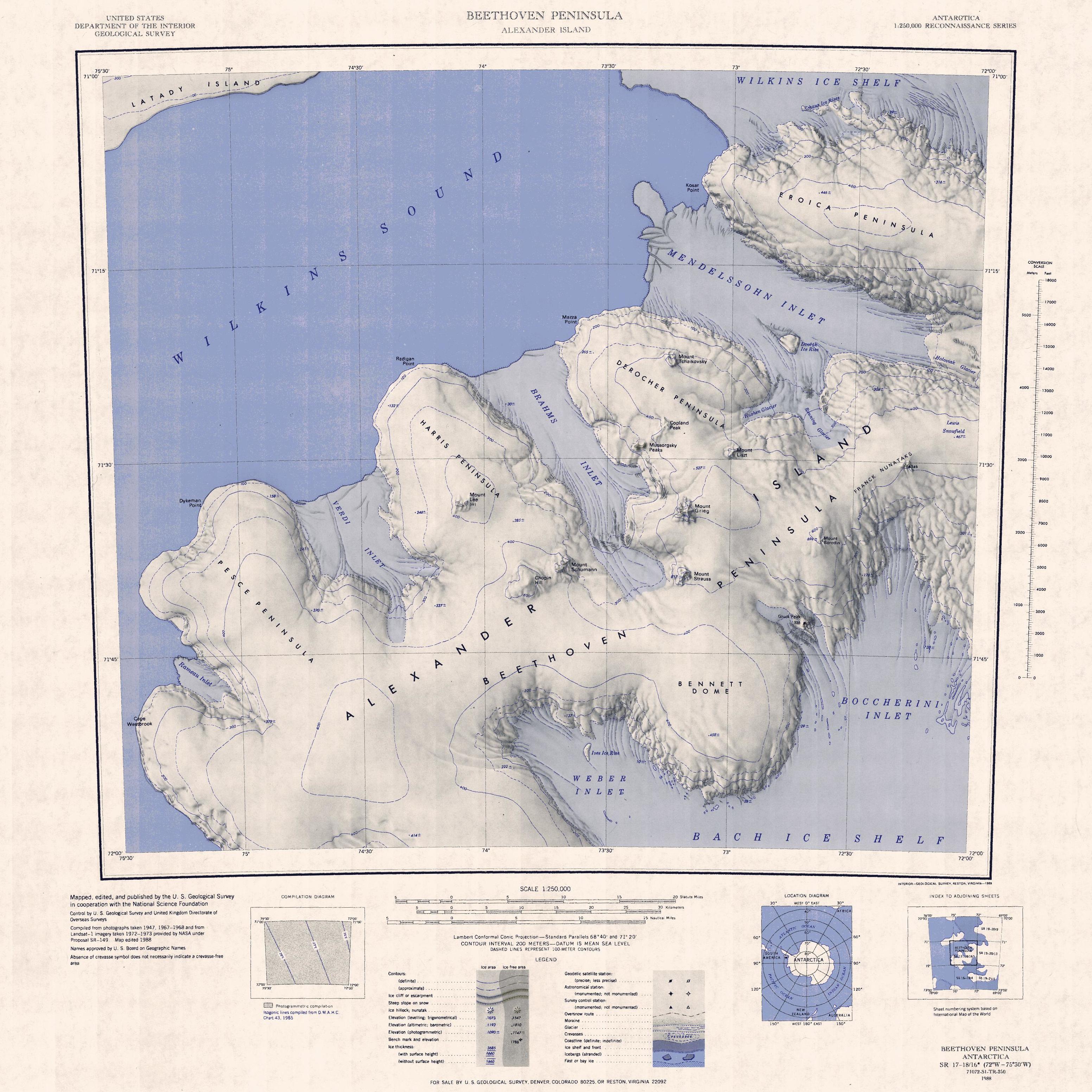
English: 1:250,000-scale topographic reconnaissance map of the Beethoven Peninsula area of Alexander Island from 72°-75°30'W to 71°-72°S in Antarctica. Mapped, edited and published by the U.S. Geological Survey in cooperation with the National Science Foundation. |
|||
| Petsa | ||||
| Gigikanan | http://usarc.usgs.gov/drg_dload.shtml | |||
| Tagsulat | United States Geological Survey | |||
| Pagtugot (Paggamit pag-usab niini nga file) |
|
Kaagi sa payl
I-klik ang petsa/oras aron makit-an ang hulagway sa payl niadtong panahona.
| Petsa/Takna | Thumbnail | Mga dimensyon | Tiggamit | Komento | |
|---|---|---|---|---|---|
| kasamtangan | 03:53, 3 Nobiyembre 2021 | | 3,104 × 3,104 (1.25 MB) | User-duck | Cropped and rotated using CropTool with precise mode. |
| 16:02, 3 Abril 2005 |  | 3,797 × 3,188 (1.53 MB) | Achim Raschka | Map of Antarctica by the United States Antarctic Ressource Center of the US Geological Society. {{PD-US}} Copyrights and Trademarks USGS-authored or produced data and information are in the public domain. While the content of most USGS web pages is in th |
Mga paggamit sa payl
Ang mosunod nga 8 panid misumpay niining payl:
Global nga paggamit sa payl
Kining ubang wiki naggamit ning maong payl:
- Paggamit sa bg.wikipedia.org
- Paggamit sa de.wikipedia.org
- Alexander-I.-Insel
- Boccherini Inlet
- Beethoven-Halbinsel
- Bennett Dome
- Weber Inlet
- Brahms Inlet
- Harris-Halbinsel
- Derocher-Halbinsel
- Verdi Inlet
- Mount Lee (Alexander-I.-Insel)
- Mendelssohn Inlet
- Pesce-Halbinsel
- Eroica-Halbinsel
- Rameau Inlet
- Kap Westbrook
- Chopin Hill
- Mount Schumann
- Copland Peak
- Mussorgsky Peaks
- Mount Grieg
- Dvořák Ice Rise
- Dykeman Point
- Rameau-Schelfeis
- Verdi-Schelfeis
- Mount Liszt
- Mount Strauss
- Mount Tchaikovsky
- Franck-Nunatakker
- Kosar Point
- Mazza Point
- Radigan Point
- Bach Inlet
- Mendelssohn-Schelfeis
- Paggamit sa en.wikipedia.org
- Paggamit sa es.wikipedia.org
- Paggamit sa fr.wikipedia.org
View more global usage of this file.