Payl:Canton River, 26 May 1841.jpg

Gidak-on ning maong paunang tan-aw: 800 x 460 ka mga piksel. Uban pang mga resoluyon: 320 x 184 ka mga piksel | 640 x 368 ka mga piksel | 1,024 x 589 ka mga piksel | 1,280 x 736 ka mga piksel | 2,629 x 1,511 ka mga piksel.
Tibuok resolusyon (2,629 × 1,511 pixels, size sa payl: 1.14 MB, MIME type: image/jpeg)
Mubong sugid:
| Description |
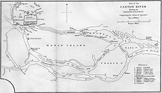
Part of the Canton River, showing the position of British ships comprising the advanced squadron, 26 May 1841. |
| Petsa | published 1844 |
| Gigikanan | William Dallas Bernard; William Hutcheon Hall (1844). Narrative of the Voyages and Services of the Nemesis, from 1840 to 1843. Volume 1. London: Henry Colburn. |
| Creator |
Isaac Purdy |
| Georeferencing | If inappropriate please set warp_status = skip to hide. |
| Other versions |
From the inset of File:Canton River and adjacent islands.jpg  |

Pagtugot
|
This work is in the public domain in its country of origin and other countries and areas where the copyright term is the author's life plus 100 years or fewer. This work is in the public domain in the United States because it was published (or registered with the U.S. Copyright Office) before January 1, 1929. | |
| This file has been identified as being free of known restrictions under copyright law, including all related and neighboring rights. | |
Kaagi sa payl
I-klik ang petsa/oras aron makit-an ang hulagway sa payl niadtong panahona.
| Petsa/Takna | Thumbnail | Mga dimensyon | Tiggamit | Komento | |
|---|---|---|---|---|---|
| kasamtangan | 13:42, 31 Oktubre 2010 | | 2,629 × 1,511 (1.14 MB) | Spellcast | == {{int:filedesc}} == {{Information |Description=Part of the Canton River, showing the position of British ships comprising the advanced squadron, 26 May 1841. |Date=Published 1844 |Source=William Dallas Bernard; William Hutcheon Hall (1844). ''[http://w |
Mga paggamit sa payl
Ang mosunod nga 2 panid misumpay niining payl:
Global nga paggamit sa payl
Kining ubang wiki naggamit ning maong payl:
- Paggamit sa bg.wikipedia.org
- Paggamit sa de.wikipedia.org
- Paggamit sa en.wikipedia.org
- Paggamit sa es.wikipedia.org
- Paggamit sa fr.wikipedia.org
- Paggamit sa id.wikipedia.org
- Paggamit sa no.wikipedia.org
- Paggamit sa ru.wikipedia.org
- Paggamit sa tr.wikipedia.org
- Paggamit sa www.wikidata.org
- Paggamit sa zh-yue.wikipedia.org
- Paggamit sa zh.wikipedia.org