Payl:Castelldwyran Church, Clynderwen - geograph.org.uk - 579647.jpg
Walay mas taas nga resolusyon.
Castelldwyran_Church,_Clynderwen_-_geograph.org.uk_-_579647.jpg (640 × 480 pixels, size sa payl: 150 KB, MIME type: image/jpeg)
Mubong sugid:
| Deskripsyon |
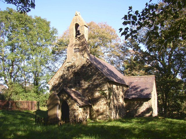
English: Castelldwyran Church, Clynderwen This church is next to a farm and no doubt on an ancient site. It was rebuilt in 1876, but is now in a very poor state with a leaking roof, big cracks in the chancel arch and woodworm in the furniture. |
| Petsa | |
| Gigikanan | From geograph.org.uk |
| Tagsulat | Humphrey Bolton |
| Attribution (required by the license) | Humphrey Bolton / Castelldwyran Church, Clynderwen / |
| Camera location | | View this and other nearby images on: OpenStreetMap |
|---|
_heading:67.00&language=ceb)
| Object location | | View this and other nearby images on: OpenStreetMap |
|---|
_heading:67.00&language=ceb)
Pagtugot

|
This image was taken from the Geograph project collection. See this photograph's page on the Geograph website for the photographer's contact details. The copyright on this image is owned by Humphrey Bolton and is licensed for reuse under the Creative Commons Attribution-ShareAlike 2.0 license.
|
This file is licensed under the Creative Commons Attribution-Share Alike 2.0 Generic license.
Attribution: Humphrey Bolton
- Libre ka:
- sa pagsabwag – sa pagkopya, pag-apod-apod ug pagsabwag sa hinimo
- sa pag-remix – sa pag-adap sa binuhat
- Ubos sa mosunod nga mga kondisyon:
- atribusyon – Kinahanglan nimo nga hatagan ang angay nga kredito, maghatag usa ka link sa lisensya, ug ipakita kung adunay mga pagbag-o. Mahimo nimo kini buhaton sa bisan unsang makatarunganon nga paagi, apan dili sa bisan unsang paagi nga nagsugyot nga gi-endorso ka sa licensor o ang imong paggamit.
- share parehas – Kung imong gi-remix, gibag-o, o gibase sa materyal, kinahanglan nimo nga iapod-apod ang imong mga kontribusyon sa ilawom sa parehas o katugma nga lisensya sama sa orihinal.
Kaagi sa payl
I-klik ang petsa/oras aron makit-an ang hulagway sa payl niadtong panahona.
| Petsa/Takna | Thumbnail | Mga dimensyon | Tiggamit | Komento | |
|---|---|---|---|---|---|
| kasamtangan | 09:37, 6 Pebrero 2011 | | 640 × 480 (150 KB) | GeographBot | == {{int:filedesc}} == {{Information |description={{en|1=Castelldwyran Church, Clynderwen This church is next to a farm and no doubt on an ancient site. It was rebuilt in 1876, but is now in a very poor state with a leaking roof, big cracks in the chance |
Mga paggamit sa payl
Ang mosunod nga mga panid misumpay niining payl:
Global nga paggamit sa payl
Kining ubang wiki naggamit ning maong payl:
- Paggamit sa cy.wikipedia.org
- Paggamit sa en.wikipedia.org
- Paggamit sa es.wikipedia.org
- Paggamit sa eu.wikipedia.org
- Paggamit sa fr.wikipedia.org
- Paggamit sa ga.wikipedia.org
- Paggamit sa gd.wikipedia.org
- Paggamit sa it.wikipedia.org
- Paggamit sa kw.wikipedia.org
- Paggamit sa www.wikidata.org