Payl:Centre of Fordingbridge - geograph.org.uk - 1525645.jpg
Walay mas taas nga resolusyon.
Centre_of_Fordingbridge_-_geograph.org.uk_-_1525645.jpg (640 × 426 pixels, size sa payl: 203 KB, MIME type: image/jpeg)
Mubong sugid:
| Deskripsyon |
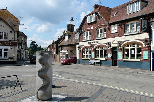
English: Centre of Fordingbridge This is the junction of Provost Street (left), Shaftesbury Street (ahead) and High Street (right) that can be regarded as the town centre. The Ship Inn probably indicates a time when the River Avon was navigable as far as the town, and the town name clearly indicates that this was the ford and later the bridge over the river. I would appreciate information about the sculpture in the foreground. The sculpture is by Paul Wilson of Salisbury. (http://wilsonsculpture.co.uk/gallery.htm) |
| Petsa | |
| Gigikanan | From geograph.org.uk |
| Tagsulat | Graham Horn |
| Attribution (required by the license) | Graham Horn / Centre of Fordingbridge / |
| Camera location | | View this and other nearby images on: OpenStreetMap |
|---|
_heading:292.00&language=ceb)
| Object location | | View this and other nearby images on: OpenStreetMap |
|---|
_heading:292.00&language=ceb)
Pagtugot

|
This image was taken from the Geograph project collection. See this photograph's page on the Geograph website for the photographer's contact details. The copyright on this image is owned by Graham Horn and is licensed for reuse under the Creative Commons Attribution-ShareAlike 2.0 license.
|
This file is licensed under the Creative Commons Attribution-Share Alike 2.0 Generic license.
Attribution: Graham Horn
- Libre ka:
- sa pagsabwag – sa pagkopya, pag-apod-apod ug pagsabwag sa hinimo
- sa pag-remix – sa pag-adap sa binuhat
- Ubos sa mosunod nga mga kondisyon:
- atribusyon – Kinahanglan nimo nga hatagan ang angay nga kredito, maghatag usa ka link sa lisensya, ug ipakita kung adunay mga pagbag-o. Mahimo nimo kini buhaton sa bisan unsang makatarunganon nga paagi, apan dili sa bisan unsang paagi nga nagsugyot nga gi-endorso ka sa licensor o ang imong paggamit.
- share parehas – Kung imong gi-remix, gibag-o, o gibase sa materyal, kinahanglan nimo nga iapod-apod ang imong mga kontribusyon sa ilawom sa parehas o katugma nga lisensya sama sa orihinal.
Kaagi sa payl
I-klik ang petsa/oras aron makit-an ang hulagway sa payl niadtong panahona.
| Petsa/Takna | Thumbnail | Mga dimensyon | Tiggamit | Komento | |
|---|---|---|---|---|---|
| kasamtangan | 02:51, 3 Marso 2011 | | 640 × 426 (203 KB) | GeographBot | == {{int:filedesc}} == {{Information |description={{en|1=Centre of Fordingbridge This is the junction of Provost Street (left), Shaftesbury Street (ahead) and High Street (right) that can be regarded as the town centre. The Ship Inn probably indicates a |
Mga paggamit sa payl
Ang mosunod nga mga panid misumpay niining payl:
Global nga paggamit sa payl
Kining ubang wiki naggamit ning maong payl:
- Paggamit sa azb.wikipedia.org
- Paggamit sa cy.wikipedia.org
- Paggamit sa de.wikipedia.org
- Paggamit sa en.wikivoyage.org
- Paggamit sa es.wikipedia.org
- Paggamit sa fa.wikipedia.org
- Paggamit sa fr.wikipedia.org
- Paggamit sa ga.wikipedia.org
- Paggamit sa it.wikipedia.org
- Paggamit sa lld.wikipedia.org
- Paggamit sa nl.wikipedia.org
- Paggamit sa ro.wikipedia.org
- Paggamit sa sv.wikipedia.org
- Paggamit sa www.wikidata.org