Payl:Coniston.jpg
Walay mas taas nga resolusyon.
Coniston.jpg (640 × 480 pixels, size sa payl: 101 KB, MIME type: image/jpeg)
Mubong sugid:
| Deskripsyon |
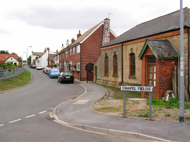
English: Village of Coniston, East Riding of Yorkshire, England. View from the west side of the village looking east. Coniston is situated on the west side of the A165 by-pass, built in 1970 running south to Hull. Within this grid square is Lane End Farm on the west edge. Seen here on the right is the now derelict Primitive Methodist Church. Coniston was known as Coningesbi in 1086, probably an Anglican, Scandinavian mixed name, possibly meaning 'Kings Farm'. |
| Petsa | |
| Gigikanan | From geograph.org.uk |
| Tagsulat | Stephen Horncastle |
| Pagtugot (Paggamit pag-usab niini nga file) |
Creative Commons Attribution Share-alike license 2.0 |
| Object location | | View this and other nearby images on: OpenStreetMap |
|---|
_region:GB-GBN_&language=ceb)
Pagtugot

|
This image was taken from the Geograph project collection. See this photograph's page on the Geograph website for the photographer's contact details. The copyright on this image is owned by Stephen Horncastle and is licensed for reuse under the Creative Commons Attribution-ShareAlike 2.0 license.
|
This file is licensed under the Creative Commons Attribution-Share Alike 2.0 Generic license.
Attribution: Stephen Horncastle
- Libre ka:
- sa pagsabwag – sa pagkopya, pag-apod-apod ug pagsabwag sa hinimo
- sa pag-remix – sa pag-adap sa binuhat
- Ubos sa mosunod nga mga kondisyon:
- atribusyon – Kinahanglan nimo nga hatagan ang angay nga kredito, maghatag usa ka link sa lisensya, ug ipakita kung adunay mga pagbag-o. Mahimo nimo kini buhaton sa bisan unsang makatarunganon nga paagi, apan dili sa bisan unsang paagi nga nagsugyot nga gi-endorso ka sa licensor o ang imong paggamit.
- share parehas – Kung imong gi-remix, gibag-o, o gibase sa materyal, kinahanglan nimo nga iapod-apod ang imong mga kontribusyon sa ilawom sa parehas o katugma nga lisensya sama sa orihinal.
Kaagi sa payl
I-klik ang petsa/oras aron makit-an ang hulagway sa payl niadtong panahona.
| Petsa/Takna | Thumbnail | Mga dimensyon | Tiggamit | Komento | |
|---|---|---|---|---|---|
| kasamtangan | 14:20, 13 Oktubre 2007 | | 640 × 480 (101 KB) | Angusmclellan | {{Information |Description=Village of Coniston in the East Riding of Yorkshire |Source=Geograph project http://www.geograph.org.uk/photo/32493 |Date=Sunday, 31 July, 2005 |Author= |
Mga paggamit sa payl
Ang mosunod nga mga panid misumpay niining payl:
Global nga paggamit sa payl
Kining ubang wiki naggamit ning maong payl:
- Paggamit sa ang.wikipedia.org
- Paggamit sa en.wikipedia.org
- Paggamit sa fr.wikipedia.org
- Paggamit sa lld.wikipedia.org
- Paggamit sa nl.wikipedia.org
- Paggamit sa pl.wikipedia.org
- Paggamit sa www.wikidata.org