Payl:Cook Islands location map.svg

Size of this PNG preview of this SVG file: 571 x 599 ka mga piksel. Uban pang mga resoluyon: 229 x 240 ka mga piksel | 457 x 480 ka mga piksel | 732 x 768 ka mga piksel | 976 x 1,024 ka mga piksel | 1,951 x 2,048 ka mga piksel | 827 x 868 ka mga piksel.
Tibuok resolusyon (SVG nga payl, nominally 827 × 868 pixels, size sa payl: 22 KB)
Mubong sugid:
| Deskripsyon |
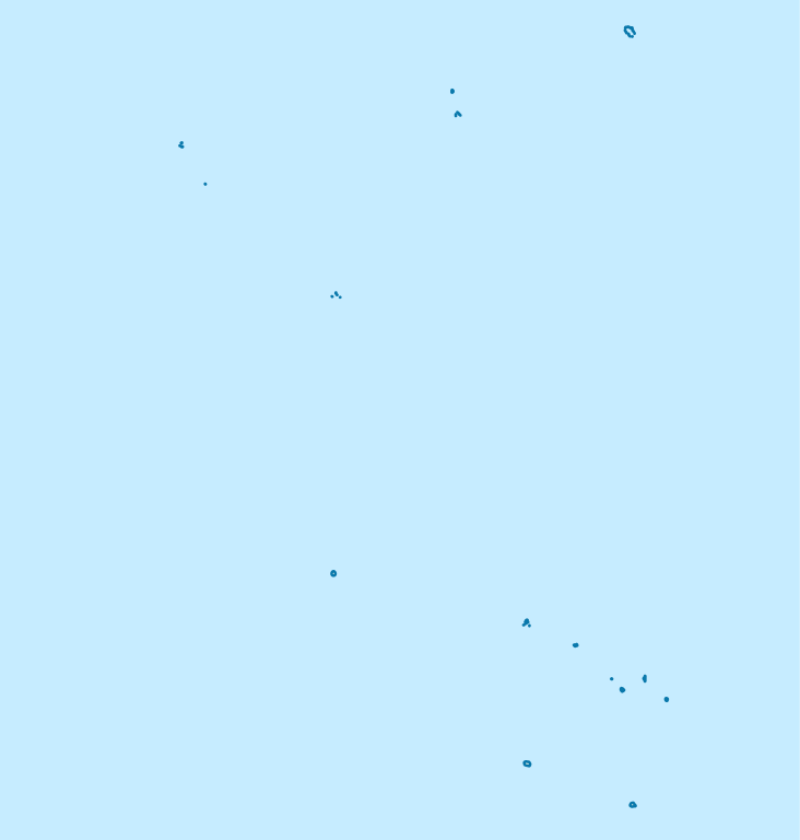
Deutsch: Positionskarte der Cookinseln
Quadratische Plattkarte, N-S-Streckung 105 %. Geographische Begrenzung der Karte:
English: Location map of the Cook Islands
Equirectangular projection, N/S stretching 105 %. Geographic limits of the map:
|
| Petsa | |
| Gigikanan | own work, using United States National Imagery and Mapping Agency data |
| Tagsulat | NordNordWest |

|
This map has been made or improved in the German Kartenwerkstatt (Map Lab). You can propose maps to improve as well.
|
Pagtugot
I, the copyright holder of this work, hereby publish it under the following licenses:

|
Gitugot ang pagkopya, pag-apud-apod o/ug pag-usab ning maong dokumento ubos sa mga termino sa GNU Free Documentation License, Version 1.2 o mas bag-ong bersiyon nga gimantala sa Free Software Foundation; nga walay Invariant Sections, walay Front-Cover Texts, ug walay Back-Cover Texts. Ang kopya sa lisensiya gilakip sa bahin nga giulohang GNU Free Documentation License. |
This file is licensed under the Creative Commons Attribution 3.0 Unported license.
- Libre ka:
- sa pagsabwag – sa pagkopya, pag-apod-apod ug pagsabwag sa hinimo
- sa pag-remix – sa pag-adap sa binuhat
- Ubos sa mosunod nga mga kondisyon:
- atribusyon – Kinahanglan nimo nga hatagan ang angay nga kredito, maghatag usa ka link sa lisensya, ug ipakita kung adunay mga pagbag-o. Mahimo nimo kini buhaton sa bisan unsang makatarunganon nga paagi, apan dili sa bisan unsang paagi nga nagsugyot nga gi-endorso ka sa licensor o ang imong paggamit.
You may select the license of your choice.
Kaagi sa payl
I-klik ang petsa/oras aron makit-an ang hulagway sa payl niadtong panahona.
| Petsa/Takna | Thumbnail | Mga dimensyon | Tiggamit | Komento | |
|---|---|---|---|---|---|
| kasamtangan | 19:02, 16 Nobiyembre 2011 | | 827 × 868 (22 KB) | NordNordWest | upd |
| 16:57, 16 Abril 2009 |  | 827 × 868 (15 KB) | NordNordWest | corr | |
| 09:14, 16 Abril 2009 |  | 591 × 868 (15 KB) | NordNordWest | {{Information |Description= {{de|Positionskarte der Cookinseln}} Quadratische Plattkarte, N-S-Streckung 105 %. Geographische Begrenzung der Karte: * N: 8.5° S * S: 22.5° S * W: 166.5° W * O: 156.5° W {{en|Location map of the [[:en:C |
Mga paggamit sa payl
More than 100 pages use this file. The following list shows the first 100 pages that use this file only. A full list is available.
- Aaron Point
- Aitutaki
- Amuri
- Anchorage Island
- Anganga
- Antiope Reef
- Araki
- Atiu
- Bennett Island
- Beveridge Reef
- Big Stone
- Bird Islands
- Black Rock
- Calcutta
- Danger Islands
- Ee
- Entrance Island
- Gull Islands
- Halfway Rock
- Hervey Islands
- High Island
- Hikurangi
- Home Island
- Humphrey
- Humphrey Island
- Iron Rock
- John Point
- Koru
- Lahu
- Leicester
- Long Rock
- Maina
- Mangaia
- Mangara
- Mangari
- Mangea
- Mangere
- Mangungu
- Manu
- Manuae
- Manunui Rock
- Marriott Reef
- Mauke Island
- Maungaroa
- Mehau Matatia
- Mitiaro
- Molokai
- Motu Ngangie
- Motu Roa
- Motu Tou
- Motutapu
- New Island
- Ngake
- Ngana
- Nicholson Island
- North East Reef
- North Island
- North Point
- North Rock
- Northern Islands
- Northwest Pass
- Omoka
- Omoko
- One Tree Island
- Oneroa
- Opi
- Palmerston
- Palmerston Island
- Papa (pagklaro)
- Paparoa
- Papua
- Patanga (pagklaro)
- Paura
- Paura (kagaangan)
- Perry
- Pohaturoa
- Primrose
- Pukapuka
- Round Reef
- San Pablo
- South Reef
- Suatumu
- Te Kainga
- Te Puka
- Tema Reef
- Tepuka
- The Needle
- The Seven Islands
- Tokarau
- Totia
- Tuirai
- Tuoro
- Turai
- Waikerikeri
- Waiouru
- Waipapa
- Wale
- West Pass
- Whale Island
- Winslow Reef
View more links to this file.
Global nga paggamit sa payl
Kining ubang wiki naggamit ning maong payl:
- Paggamit sa af.wikipedia.org
- Paggamit sa an.wikipedia.org
- Paggamit sa ar.wikipedia.org
- Paggamit sa ast.wikipedia.org
- Paggamit sa az.wikipedia.org
- Paggamit sa be.wikipedia.org
- Paggamit sa bg.wikipedia.org
- Paggamit sa bn.wikipedia.org
- Paggamit sa cs.wikipedia.org
- Paggamit sa de.wikipedia.org
- Aitutaki
- Rarotonga
- Mangaia
- Penrhyn
- Atiu
- Avarua
- Manuae (Cookinseln)
- Pukapuka (Cookinseln)
- Suwarrow
- Takutea
- Nassau (Cookinseln)
- Mauke (Insel)
- Mitiaro
- Palmerston (Cookinseln)
- Rakahanga
- Manihiki
- Avarua National Stadium
- Wikipedia:Kartenwerkstatt/Positionskarten/Australien und Ozeanien
- Vorlage:Positionskarte Cookinseln
- Flughafen Rarotonga
- Wikipedia:Kartenwerkstatt/Archiv/2009-04
- Te Manga
- Wikipedia:Kartenwerkstatt/Archiv/2010-09
- Flughafen Aitutaki
View more global usage of this file.