Payl:Debre Tabor skyline.jpg

Gidak-on ning maong paunang tan-aw: 800 x 541 ka mga piksel. Uban pang mga resoluyon: 320 x 216 ka mga piksel | 640 x 433 ka mga piksel | 1,024 x 693 ka mga piksel | 1,280 x 866 ka mga piksel | 2,560 x 1,732 ka mga piksel | 3,264 x 2,208 ka mga piksel.
Tibuok resolusyon (3,264 × 2,208 pixels, size sa payl: 867 KB, MIME type: image/jpeg)
https://www.facebook.com/Debre.Tabore==Mubong sugid:==
| Deskripsyon |
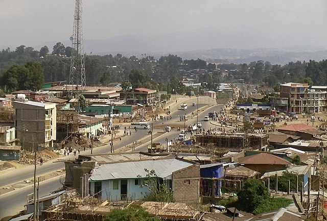
English: Looking east over the main road through Debre Tabor, Ethiopia. the central market area is to the right of the image. 100 meters directly behind the camera is the Hibret Hotel. 100 meters behind and to the left of the camera (across the road) is the bus station. |
|||
| Petsa | ||||
| Gigikanan | Kaugalingong trabaho | |||
| Tagsulat | Brian Dell | |||
| Pagtugot (Paggamit pag-usab niini nga file) |
I, the copyright holder of this work, hereby publish it under the following license:
|
| Camera location | | View this and other nearby images on: OpenStreetMap |
|---|
Kaagi sa payl
I-klik ang petsa/oras aron makit-an ang hulagway sa payl niadtong panahona.
| Petsa/Takna | Thumbnail | Mga dimensyon | Tiggamit | Komento | |
|---|---|---|---|---|---|
| kasamtangan | 18:29, 12 Abril 2011 | | 3,264 × 2,208 (867 KB) | Bdell555 |
Mga paggamit sa payl
Ang mosunod nga mga panid misumpay niining payl:
Global nga paggamit sa payl
Kining ubang wiki naggamit ning maong payl:
- Paggamit sa ar.wikipedia.org
- Paggamit sa arz.wikipedia.org
- Paggamit sa de.wikipedia.org
- Paggamit sa es.wikipedia.org
- Paggamit sa fi.wikipedia.org
- Paggamit sa fr.wikipedia.org
- Paggamit sa id.wikipedia.org
- Paggamit sa it.wikipedia.org
- Paggamit sa pl.wikipedia.org
- Paggamit sa ro.wikipedia.org
- Paggamit sa sv.wikipedia.org
- Paggamit sa www.wikidata.org