Payl:ET Amhara asv2018-02 img023 Wunenia.jpg

Gidak-on ning maong paunang tan-aw: 800 x 400 ka mga piksel. Uban pang mga resoluyon: 320 x 160 ka mga piksel | 640 x 320 ka mga piksel | 1,024 x 512 ka mga piksel | 1,280 x 640 ka mga piksel | 2,560 x 1,280 ka mga piksel | 11,228 x 5,614 ka mga piksel.
Tibuok resolusyon (11,228 × 5,614 pixels, size sa payl: 28.1 MB, MIME type: image/jpeg)
Mubong sugid:
| Deskripsyon |
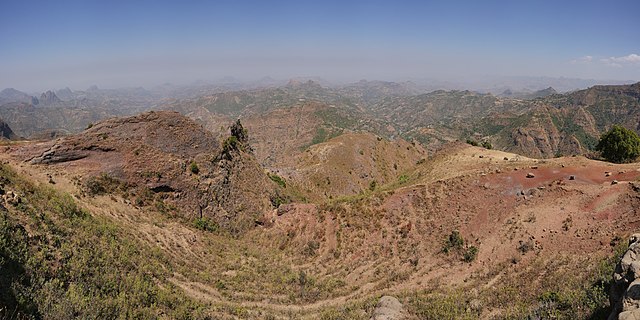
English: Landscape at Wunenia near Gondar, Ethiopia
Русский: Ландшафт в Вунении недалеко от Гондара, Эфиопия |
| Petsa | |
| Gigikanan | Kaugalingong trabaho |
| Tagsulat | A.Savin |
| Pagtugot (Paggamit pag-usab niini nga file) |
.svg) Just attribute the author: «A.Savin, Wikipedia»; if you have questions — Telegram, or e-mail to wikiphotospace@gmail.com..svg) Просто укажите в качестве автора: «А.Савин, Википедия»; если есть вопрос — телеграм, или эл.почта на wikiphotospace@gmail.com. Kennzeichnen Sie einfach als Autor: «A.Savin, Wikipedia»; falls Sie Fragen haben — Telegram, oder E-Mail an wikiphotospace@gmail.com.
Thank you. |
| Camera location | | View this and other nearby images on: OpenStreetMap |
|---|

|
NOTE: This image is a panorama consisting of 7 frames that were merged or stitched in PTGui. As a result, this image necessarily underwent some form of digital manipulation. These manipulations may include blending, blurring, cloning, and colour and perspective adjustments. As a result of these adjustments, the image content may be slightly different from reality at the points where multiple images were combined. This manipulation is often required due to lens, perspective, and parallax distortions.
|
Pagtugot
| Copyleft: This work of art is free; you can redistribute it and/or modify it according to terms of the Free Art License. You will find a specimen of this license on the Copyleft Attitude site as well as on other sites. |
Kaagi sa payl
I-klik ang petsa/oras aron makit-an ang hulagway sa payl niadtong panahona.
| Petsa/Takna | Thumbnail | Mga dimensyon | Tiggamit | Komento | |
|---|---|---|---|---|---|
| kasamtangan | 19:59, 31 Mayo 2018 | | 11,228 × 5,614 (28.1 MB) | A.Savin | {{User:A.Savin/F |Description= {{en|Landscape at Wunenia near Gondar, Ethiopia}} {{ru|Ландшафт в Вунении недалеко от Гондара, Эфиопия}} |Year=2018 |Country=Ethiopia |Month=02 |Day=02}} {{Location|12|45|1.7|N|37|30|26.7|E|region:ET-AM}} {{Panorama|2=7|3=[http://www.ptgui.com/ PTGui]}} Category:Taken with Sony ILCE-7RM3 Category:Taken with Sony FE 24-105mm F4 G OSS Category:Created with PTgui Category:2018 in Ethiopia Category:Panoramics in Ethiopia [[Category:Kosoye and Wu... |
Mga paggamit sa payl
Ang mosunod nga mga panid misumpay niining payl:
Global nga paggamit sa payl
Kining ubang wiki naggamit ning maong payl:
- Paggamit sa ar.wikipedia.org
- Paggamit sa arz.wikipedia.org
- Paggamit sa ast.wikipedia.org
- Paggamit sa az.wikipedia.org
- Paggamit sa ba.wikipedia.org
- Paggamit sa ca.wikipedia.org
- Paggamit sa cs.wikipedia.org
- Paggamit sa eo.wikipedia.org
- Paggamit sa he.wikipedia.org
- Paggamit sa lld.wikipedia.org
- Paggamit sa uk.wikipedia.org
- Paggamit sa www.wikidata.org