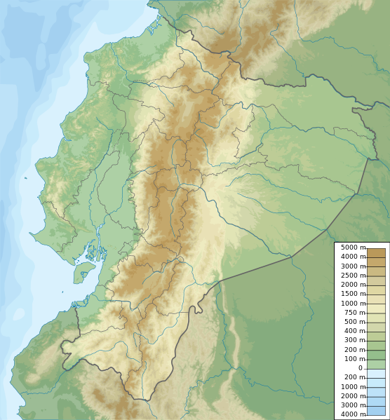
Payl:Ecuador relief location map.svg

Size of this PNG preview of this SVG file: 556 x 599 ka mga piksel. Uban pang mga resoluyon: 223 x 240 ka mga piksel | 445 x 480 ka mga piksel | 713 x 768 ka mga piksel | 950 x 1,024 ka mga piksel | 1,901 x 2,048 ka mga piksel | 851 x 917 ka mga piksel.
Tibuok resolusyon (SVG nga payl, nominally 851 × 917 pixels, size sa payl: 3.76 MB)
Mubong sugid:
| Deskripsyon | Ecuador physical map, parameters equal to File:Ecuador location map.svg |
| Petsa | |
| Gigikanan | Kaugalingong trabaho |
| Tagsulat | Urutseg |
Pagtugot
I, the copyright holder of this work, hereby publish it under the following license:
| This file is made available under the Creative Commons CC0 1.0 Universal Public Domain Dedication. | |
| The person who associated a work with this deed has dedicated the work to the public domain by waiving all of their rights to the work worldwide under copyright law, including all related and neighboring rights, to the extent allowed by law. You can copy, modify, distribute and perform the work, even for commercial purposes, all without asking permission.
|
Kaagi sa payl
I-klik ang petsa/oras aron makit-an ang hulagway sa payl niadtong panahona.
| Petsa/Takna | Thumbnail | Mga dimensyon | Tiggamit | Komento | |
|---|---|---|---|---|---|
| kasamtangan | 19:49, 15 Oktubre 2012 | | 851 × 917 (3.76 MB) | Milenioscuro | corrections of coastal line and boundaries (according to Ecuador location map.svg) |
| 15:16, 26 Agosto 2012 |  | 1,536 × 1,654 (2.49 MB) | Joffrenomuere | son 24 Provincias no 22 | |
| 08:04, 15 Hunyo 2012 |  | 851 × 917 (2.13 MB) | TUBS | rv: please follow map conventions, cf your disk | |
| 18:53, 13 Hunyo 2012 |  | 851 × 917 (2.35 MB) | Joffrenomuere | 24 provincias | |
| 19:00, 14 Marso 2011 |  | 851 × 917 (2.13 MB) | Urutseg |
Mga paggamit sa payl
Ang mosunod nga 2 panid misumpay niining payl:
Global nga paggamit sa payl
Kining ubang wiki naggamit ning maong payl:
- Paggamit sa ar.wikipedia.org
- Paggamit sa ast.wikipedia.org
- Paggamit sa azb.wikipedia.org
- Paggamit sa az.wikipedia.org
- Paggamit sa ban.wikipedia.org
- Paggamit sa be.wikipedia.org
- Paggamit sa bg.wikipedia.org
- Paggamit sa bh.wikipedia.org
- Paggamit sa bn.wikipedia.org
- Paggamit sa bs.wikipedia.org
View more global usage of this file.