Payl:Firehole river at Upper Geyser Basin-2008-june.jpg

Gidak-on ning maong paunang tan-aw: 800 x 575 ka mga piksel. Uban pang mga resoluyon: 320 x 230 ka mga piksel | 640 x 460 ka mga piksel | 1,024 x 736 ka mga piksel | 1,280 x 920 ka mga piksel | 2,100 x 1,509 ka mga piksel.
Tibuok resolusyon (2,100 × 1,509 pixels, size sa payl: 2.73 MB, MIME type: image/jpeg)
Mubong sugid:
| Deskripsyon |
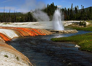
English: Cliff geyser and Iron Spring Creek at Black Sand Basin in Upper Geyser Basin in Yellowstone National Park
Français : Iron Spring Creek et Cliff geyser dans le Parc national de Yellowstone |
| Petsa | |
| Gigikanan | Kaugalingong trabaho |
| Tagsulat | Brocken Inaglory |
| Camera location | | View this and other nearby images on: OpenStreetMap |
|---|
Pagtugot
I, the copyright holder of this work, hereby publish it under the following licenses:
This file is licensed under the Creative Commons Attribution-Share Alike 3.0 Unported license.
- Libre ka:
- sa pagsabwag – sa pagkopya, pag-apod-apod ug pagsabwag sa hinimo
- sa pag-remix – sa pag-adap sa binuhat
- Ubos sa mosunod nga mga kondisyon:
- atribusyon – Kinahanglan nimo nga hatagan ang angay nga kredito, maghatag usa ka link sa lisensya, ug ipakita kung adunay mga pagbag-o. Mahimo nimo kini buhaton sa bisan unsang makatarunganon nga paagi, apan dili sa bisan unsang paagi nga nagsugyot nga gi-endorso ka sa licensor o ang imong paggamit.
- share parehas – Kung imong gi-remix, gibag-o, o gibase sa materyal, kinahanglan nimo nga iapod-apod ang imong mga kontribusyon sa ilawom sa parehas o katugma nga lisensya sama sa orihinal.

|
Gitugot ang pagkopya, pag-apud-apod o/ug pag-usab ning maong dokumento ubos sa mga termino sa GNU Free Documentation License, Version 1.2 o mas bag-ong bersiyon nga gimantala sa Free Software Foundation; nga walay Invariant Sections, walay Front-Cover Texts, ug walay Back-Cover Texts. Ang kopya sa lisensiya gilakip sa bahin nga giulohang GNU Free Documentation License. |
You may select the license of your choice.
Assessment
|

This image was selected as picture of the day on Wikimedia Commons for 5 July 2009. It was captioned as follows: English: Cliff Geyser and Firehole River at Black Sand Basin in Upper Geyser Basin in Yellowstone National Park. Other languages:
Dansk: Cliff-gejseren og floden Firehole River ved Black Sand Basin i det øvre gejserbassin i Yellowstone National Park. English: Cliff Geyser and Firehole River at Black Sand Basin in Upper Geyser Basin in Yellowstone National Park. Italiano: Il Cliff Geyser e il Firehole River presso il Black Sand Basin nel Parco nazionale di Yellowstone, Stati Uniti. Nederlands: De geiser Cliff bij de rivier de Firehole in Black Sand, een geïsoleerde groep geisers van de Upper Geyser Basin in het Amerikaanse nationaal park Yellowstone. Polski: Gejzer klifowy i rzeka Firehole w niecce gejzerowej Black Sand w Parku Narodowym Yellowstone, Stany Zjednoczone. Македонски: Клифскиот гејзер и реката Фајрхол во басенот Блек Сенд во Горниот гејзерски басен во националниот парк Јелоустоун, САД. 中文: 美国黄石国家公园上间歇泉盆地黑砂盆地悬崖间歇泉及火洞河。 |
Kaagi sa payl
I-klik ang petsa/oras aron makit-an ang hulagway sa payl niadtong panahona.
| Petsa/Takna | Thumbnail | Mga dimensyon | Tiggamit | Komento | |
|---|---|---|---|---|---|
| kasamtangan | 19:40, 23 Abril 2009 | | 2,100 × 1,509 (2.73 MB) | Mbz1 | corrected color balance |
| 19:10, 23 Abril 2009 |  | 2,100 × 1,509 (2.72 MB) | Mbz1 | reduced noise | |
| 19:01, 23 Abril 2009 |  | 2,100 × 1,509 (2.72 MB) | Mbz1 | corrected color balance | |
| 18:51, 23 Abril 2009 |  | 2,100 × 1,509 (2.62 MB) | Mbz1 | {{Information |Description={{en|1=Firehole river at Upper Geyser Basin}} |Source=Own work by uploader |Author=Mbz1 |Date= |Permission= |other_versions= }} <!--{{ImageUpload|full}}--> |
Mga paggamit sa payl
Ang mosunod nga mga panid misumpay niining payl:
Global nga paggamit sa payl
Kining ubang wiki naggamit ning maong payl:
- Paggamit sa bn.wikipedia.org
- Paggamit sa crh.wikipedia.org
- Paggamit sa cv.wikipedia.org
- Paggamit sa da.wikipedia.org
- Paggamit sa de.wikipedia.org
- Paggamit sa de.wikivoyage.org
- Paggamit sa en.wikipedia.org
- Paggamit sa eo.wikipedia.org
- Paggamit sa eu.wikipedia.org
- Paggamit sa fi.wikipedia.org
- Paggamit sa fr.wikipedia.org
- Paggamit sa fr.wikiversity.org
- Paggamit sa hu.wikipedia.org
- Paggamit sa ko.wikipedia.org
- Paggamit sa lbe.wikipedia.org
- Paggamit sa mg.wikipedia.org
- Paggamit sa mk.wikipedia.org
- Paggamit sa nl.wikivoyage.org
- Paggamit sa os.wikipedia.org
- Paggamit sa pl.wikipedia.org
- Paggamit sa pt.wikipedia.org
- Paggamit sa ru.wikipedia.org
- Paggamit sa ru.wikinews.org
- Paggamit sa ru.wikivoyage.org
- Paggamit sa sah.wikipedia.org
- Paggamit sa sr.wikipedia.org
- Paggamit sa sv.wikipedia.org
- Paggamit sa tr.wikipedia.org
- Paggamit sa uk.wikipedia.org
- Paggamit sa vi.wikipedia.org
- Paggamit sa www.wikidata.org
- Paggamit sa xal.wikipedia.org
- Paggamit sa zh.wikipedia.org