Payl:Fukushima City with a view of Fukushima Station.jpg

Gidak-on ning maong paunang tan-aw: 800 x 532 ka mga piksel. Uban pang mga resoluyon: 320 x 213 ka mga piksel | 640 x 425 ka mga piksel | 1,024 x 681 ka mga piksel | 1,280 x 851 ka mga piksel | 2,560 x 1,701 ka mga piksel | 3,957 x 2,630 ka mga piksel.
Tibuok resolusyon (3,957 × 2,630 pixels, size sa payl: 2.51 MB, MIME type: image/jpeg)
Mubong sugid:
| Deskripsyon |
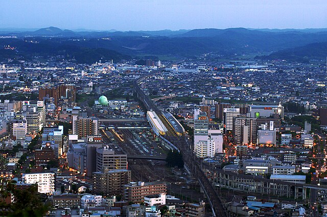
English: This is a view of Fukushima City, Fukushima Prefecture, Japan centered upon Fukushima Station.
Running from south (top of photo) to north (bottom of photo), the Tohoku Shinkansen connects Tokyo with the northeastern part of Honshu island, running all the way up to Aomori Prefecture. Fukushima Station's importance lies in that it's where the Yamagata Shinkansen (bottom right) splits off from the Tohoku Shinkansen and heads off on its own.
日本語: 福島県福島市の中心にある信夫山からの写真。福島駅は真ん中にある。 |
| Petsa | |
| Gigikanan | Kaugalingong trabaho |
| Tagsulat | Purplepumpkins |
| Camera location | | View this and other nearby images on: OpenStreetMap |
|---|
Pagtugot
I, the copyright holder of this work, hereby publish it under the following license:
This file is licensed under the Creative Commons Attribution-Share Alike 3.0 Unported license.
- Libre ka:
- sa pagsabwag – sa pagkopya, pag-apod-apod ug pagsabwag sa hinimo
- sa pag-remix – sa pag-adap sa binuhat
- Ubos sa mosunod nga mga kondisyon:
- atribusyon – Kinahanglan nimo nga hatagan ang angay nga kredito, maghatag usa ka link sa lisensya, ug ipakita kung adunay mga pagbag-o. Mahimo nimo kini buhaton sa bisan unsang makatarunganon nga paagi, apan dili sa bisan unsang paagi nga nagsugyot nga gi-endorso ka sa licensor o ang imong paggamit.
- share parehas – Kung imong gi-remix, gibag-o, o gibase sa materyal, kinahanglan nimo nga iapod-apod ang imong mga kontribusyon sa ilawom sa parehas o katugma nga lisensya sama sa orihinal.
Kaagi sa payl
I-klik ang petsa/oras aron makit-an ang hulagway sa payl niadtong panahona.
| Petsa/Takna | Thumbnail | Mga dimensyon | Tiggamit | Komento | |
|---|---|---|---|---|---|
| kasamtangan | 06:04, 23 Hunyo 2011 | | 3,957 × 2,630 (2.51 MB) | Purplepumpkins |
Mga paggamit sa payl
Ang mosunod nga mga panid misumpay niining payl:
Global nga paggamit sa payl
Kining ubang wiki naggamit ning maong payl:
- Paggamit sa af.wikipedia.org
- Paggamit sa ar.wikipedia.org
- Paggamit sa arz.wikipedia.org
- Paggamit sa azb.wikipedia.org
- Paggamit sa az.wikipedia.org
- Paggamit sa ca.wikipedia.org
- Paggamit sa ce.wikipedia.org
- Paggamit sa de.wikivoyage.org
- Paggamit sa el.wikipedia.org
- Paggamit sa en.wikipedia.org
- Paggamit sa en.wikivoyage.org
- Paggamit sa eo.wikipedia.org
- Paggamit sa es.wikipedia.org
- Paggamit sa fa.wikipedia.org
- Paggamit sa fi.wikipedia.org
- Paggamit sa fr.wikipedia.org
- Paggamit sa fr.wikivoyage.org
- Paggamit sa ga.wikipedia.org
- Paggamit sa gl.wikipedia.org
- Paggamit sa hr.wikipedia.org
- Paggamit sa hy.wikipedia.org
- Paggamit sa id.wikipedia.org
- Paggamit sa it.wikipedia.org
- Paggamit sa ja.wikipedia.org
- Paggamit sa ja.wikivoyage.org
- Paggamit sa kn.wikipedia.org
- Paggamit sa lt.wikipedia.org
- Paggamit sa lv.wikipedia.org
- Paggamit sa ml.wikipedia.org
- Paggamit sa my.wikipedia.org
- Paggamit sa no.wikipedia.org
- Paggamit sa pl.wikipedia.org
- Paggamit sa pl.wikivoyage.org
- Paggamit sa pt.wikipedia.org
- Paggamit sa pt.wiktionary.org
- Paggamit sa ru.wikipedia.org
- Paggamit sa sc.wikipedia.org
- Paggamit sa sh.wikipedia.org
- Paggamit sa simple.wikipedia.org
- Paggamit sa sq.wikipedia.org
- Paggamit sa sr.wikipedia.org
- Paggamit sa sw.wikipedia.org
View more global usage of this file.