Payl:Greatbasinmap.png

Gidak-on ning maong paunang tan-aw: 536 x 599 ka mga piksel. Uban pang mga resoluyon: 215 x 240 ka mga piksel | 430 x 480 ka mga piksel | 687 x 768 ka mga piksel | 916 x 1,024 ka mga piksel | 1,500 x 1,676 ka mga piksel.
Tibuok resolusyon (1,500 × 1,676 pixels, size sa payl: 7.21 MB, MIME type: image/png)
Mubong sugid:
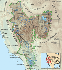
| Deskripsyon | Map showing the Great Basin drainage basin as defined hydrologically. |
| Petsa | |
| Gigikanan | Kaugalingong trabaho, Elevation data from SRTM, all other features from the National Atlas. Rand McNally, The New International Atlas, 1993 used as reference. |
| Tagsulat | Kmusser |
| Other versions |
 |
Pagtugot
I, the copyright holder of this work, hereby publish it under the following license:
This file is licensed under the Creative Commons Attribution-Share Alike 3.0 Unported license.
- Libre ka:
- sa pagsabwag – sa pagkopya, pag-apod-apod ug pagsabwag sa hinimo
- sa pag-remix – sa pag-adap sa binuhat
- Ubos sa mosunod nga mga kondisyon:
- atribusyon – Kinahanglan nimo nga hatagan ang angay nga kredito, maghatag usa ka link sa lisensya, ug ipakita kung adunay mga pagbag-o. Mahimo nimo kini buhaton sa bisan unsang makatarunganon nga paagi, apan dili sa bisan unsang paagi nga nagsugyot nga gi-endorso ka sa licensor o ang imong paggamit.
- share parehas – Kung imong gi-remix, gibag-o, o gibase sa materyal, kinahanglan nimo nga iapod-apod ang imong mga kontribusyon sa ilawom sa parehas o katugma nga lisensya sama sa orihinal.
Kaagi sa payl
I-klik ang petsa/oras aron makit-an ang hulagway sa payl niadtong panahona.
| Petsa/Takna | Thumbnail | Mga dimensyon | Tiggamit | Komento | |
|---|---|---|---|---|---|
| kasamtangan | 22:25, 4 Septiyembre 2020 | | 1,500 × 1,676 (7.21 MB) | Nwbeeson | Added boundary map. Second attempt to upload the image. |
| 22:21, 4 Septiyembre 2020 |  | 1,500 × 1,676 (7.21 MB) | Nwbeeson | Added boundary line. | |
| 16:58, 11 Disyembre 2010 |  | 1,500 × 1,676 (3.64 MB) | Kmusser | Added Goose Lake | |
| 20:37, 17 Nobiyembre 2010 |  | 1,500 × 1,676 (3.23 MB) | Kmusser | == Summary == {{Information |Description=Map showing the Great Basin drainage basin as defined hydrologically. |Source={{own}}, Elevation data from SRTM, all other features from the [[:w:National |
Mga paggamit sa payl
There are no pages that use this file.
Global nga paggamit sa payl
Kining ubang wiki naggamit ning maong payl:
- Paggamit sa ar.wikipedia.org
- Paggamit sa ast.wikipedia.org
- Paggamit sa az.wikipedia.org
- Paggamit sa bg.wikipedia.org
- Paggamit sa bn.wikipedia.org
- Paggamit sa bs.wikipedia.org
- Paggamit sa ckb.wikipedia.org
- Paggamit sa cs.wikipedia.org
- Paggamit sa de.wikipedia.org
- Paggamit sa es.wikipedia.org
- Paggamit sa et.wikipedia.org
- Paggamit sa fa.wikipedia.org
- Paggamit sa fi.wikipedia.org
- Paggamit sa fr.wikipedia.org
- Paggamit sa fy.wikipedia.org
- Paggamit sa he.wikipedia.org
- Paggamit sa id.wikipedia.org
- Paggamit sa is.wikipedia.org
- Paggamit sa it.wikipedia.org
- Paggamit sa ja.wikipedia.org
- Paggamit sa ka.wikipedia.org
- Paggamit sa kk.wikipedia.org
- Paggamit sa kn.wikipedia.org
- Paggamit sa ko.wikipedia.org
- Paggamit sa lfn.wikipedia.org
- Paggamit sa li.wikipedia.org
- Paggamit sa lt.wikipedia.org
- Paggamit sa mk.wikipedia.org
- Paggamit sa ml.wikipedia.org
- Paggamit sa mr.wikipedia.org
- Paggamit sa nl.wikipedia.org
- Paggamit sa nn.wikipedia.org
- Paggamit sa pa.wikipedia.org
- Paggamit sa pl.wikipedia.org
- Paggamit sa pnb.wikipedia.org
- Paggamit sa pt.wikipedia.org
- Paggamit sa ru.wikipedia.org
- Paggamit sa simple.wikipedia.org
- Paggamit sa sq.wikipedia.org
- Paggamit sa sw.wikipedia.org
- Paggamit sa ta.wikipedia.org
- Paggamit sa tr.wikipedia.org
- Paggamit sa uk.wikipedia.org
- Paggamit sa uz.wikipedia.org
View more global usage of this file.