Payl:Hewler governorate 2012.png

Gidak-on ning maong paunang tan-aw: 469 x 599 ka mga piksel. Uban pang mga resoluyon: 188 x 240 ka mga piksel | 376 x 480 ka mga piksel | 700 x 894 ka mga piksel.
Tibuok resolusyon (700 × 894 pixels, size sa payl: 62 KB, MIME type: image/png)
Mubong sugid:
| Deskripsyon |
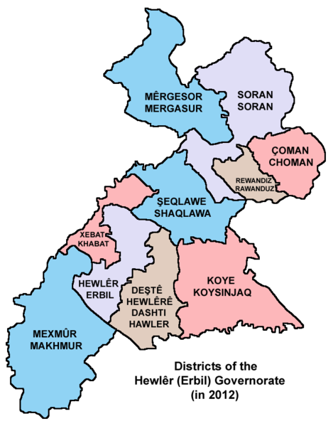
English: Map showing the districts of the Hewlêr (Erbil) Governorate of Kurdistan Region in Iraq (in 2012). |
| Petsa | |
| Gigikanan | Kaugalingong trabaho |
| Tagsulat | PANONIAN |
Pagtugot
I, the copyright holder of this work, hereby publish it under the following license:
| This file is made available under the Creative Commons CC0 1.0 Universal Public Domain Dedication. | |
| The person who associated a work with this deed has dedicated the work to the public domain by waiving all of their rights to the work worldwide under copyright law, including all related and neighboring rights, to the extent allowed by law. You can copy, modify, distribute and perform the work, even for commercial purposes, all without asking permission.
|
Refences
Borders of districts of the Hewlêr (Erbil) Governorate are made in accordance with these maps provided by the Kurdistan Region Statistics Office:
- http://www.krso.net/en/maps
- http://www.krso.net/documents/78/SubDistricts%20of%20the%20Governorates%20of%20Kurdistan%20Region.jpg
- http://www.krso.net/documents/38/Districts%20of%20the%20Governorates%20of%20Kurdistan%20Region.jpg
Kaagi sa payl
I-klik ang petsa/oras aron makit-an ang hulagway sa payl niadtong panahona.
| Petsa/Takna | Thumbnail | Mga dimensyon | Tiggamit | Komento | |
|---|---|---|---|---|---|
| kasamtangan | 19:57, 10 Septiyembre 2014 | | 700 × 894 (62 KB) | PANONIAN | {{Information |Description ={{en|1=Map showing the districts of the Hewlêr (Erbil) Governorate of Kurdistan Region in Iraq (in 2012).}} |Source ={{own}} |Author =PANONIAN |Date =2014 |Permission = |ot... |
Mga paggamit sa payl
Ang mosunod nga mga panid misumpay niining payl:
Global nga paggamit sa payl
Kining ubang wiki naggamit ning maong payl:
- Paggamit sa arc.wikipedia.org
- Paggamit sa ar.wikipedia.org
- شقلاوة
- قضاء مخمور
- أربيل
- ناحية سيدكان
- جومان
- قضاء أربيل
- ناحية بحركة
- ناحية شمامك
- ناحية صلاح الدين
- ناحية هيران
- ناحية حرير
- ناحية باسرمة
- ناحية باليسان
- قضاء ميركسور
- ناحية دارتو
- ناحية قوشتبة
- ناحية رزكاري
- ناحية كسنزان
- ناحية خليفان
- ناحية ديانا
- ناحية بارزان
- ناحية بيران
- ناحية شيروان مزن
- ناحية مزني
- ناحية كورتو
- ناحية دارشكران
- ناحية كوركوسك
- ناحية ورتي
- قضاء جومان
- ناحية سميلان
- ناحية كلالة
- ناحية قسري
- ناحية طق طق
- ناحية شورش
- ناحية آشتي
- ناحية سكتان
- ناحية سيكردكان
- خبات
- ناحية قراج
- قالب:محافظة أربيل
- ناحية كنديناوة
- Paggamit sa arz.wikipedia.org
- Paggamit sa bg.wikipedia.org
- Paggamit sa bn.wikipedia.org
- Paggamit sa ckb.wikipedia.org
View more global usage of this file.