Payl:Izumo in Shimane Prefecture Ja.svg

Tibuok resolusyon (SVG nga payl, nominally 610 × 579 pixels, size sa payl: 28 KB)
Mubong sugid:
| Deskripsyon |
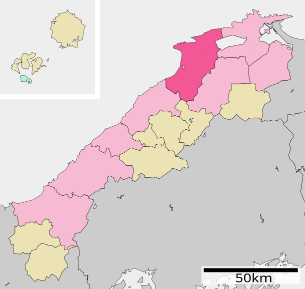
English: Location of Izumo in Shimane Prefecture
|
||
| Petsa | (UTC) | ||
| Gigikanan |
|
||
| Tagsulat | Lincun | ||
| Pagtugot (Paggamit pag-usab niini nga file) |
|
Pagtugot

|
Gitugot ang pagkopya, pag-apud-apod o/ug pag-usab ning maong dokumento ubos sa mga termino sa GNU Free Documentation License, Version 1.2 o mas bag-ong bersiyon nga gimantala sa Free Software Foundation; nga walay Invariant Sections, walay Front-Cover Texts, ug walay Back-Cover Texts. Ang kopya sa lisensiya gilakip sa bahin nga giulohang GNU Free Documentation License. |
- Libre ka:
- sa pagsabwag – sa pagkopya, pag-apod-apod ug pagsabwag sa hinimo
- sa pag-remix – sa pag-adap sa binuhat
- Ubos sa mosunod nga mga kondisyon:
- atribusyon – Kinahanglan nimo nga hatagan ang angay nga kredito, maghatag usa ka link sa lisensya, ug ipakita kung adunay mga pagbag-o. Mahimo nimo kini buhaton sa bisan unsang makatarunganon nga paagi, apan dili sa bisan unsang paagi nga nagsugyot nga gi-endorso ka sa licensor o ang imong paggamit.
- share parehas – Kung imong gi-remix, gibag-o, o gibase sa materyal, kinahanglan nimo nga iapod-apod ang imong mga kontribusyon sa ilawom sa parehas o katugma nga lisensya sama sa orihinal.
Original upload log
| This file was moved from Japanese Wikipedia.
See below for original file information. | ||||||||||||||||||||||||||||
| ||||||||||||||||||||||||||||
|
| ||||||||||||||||||||||||||||
Kaagi sa payl
I-klik ang petsa/oras aron makit-an ang hulagway sa payl niadtong panahona.
| Petsa/Takna | Thumbnail | Mga dimensyon | Tiggamit | Komento | |
|---|---|---|---|---|---|
| kasamtangan | 00:13, 9 Marso 2013 | | 610 × 579 (28 KB) | 猿払の天馬 | 色の変更・距離の表示を地図の中へ・簸川郡斐川町を出雲市と合併、八束郡東出雲町を松江市と合併。 |
| 00:10, 9 Marso 2013 |  | 610 × 579 (28 KB) | 猿払の天馬 | The color was changed.,The display of distance was put in the map. Hikawa town belonging to Hikawa district was merged with Izumo city.,Higashiizumo town belonging to Yatsuka district was merged with Matsue city. | |
| 14:16, 26 Septiyembre 2009 |  | 610 × 652 (13 KB) | Monaneko | {{Information |Description={{en|1=Location of Izumo in Shimane Prefecture}} {{ja|1=島根県出雲市の位置}} |Source=ja:File:基礎自治体位置図 32202.svg |Author=ja:User:Lincun |Date=2007-10-14 14:21 (UTC) |Permission= |other_versions= | |
| 14:21, 14 Oktubre 2007 |  | 610 × 652 (13 KB) | Lincun | {{基礎自治体位置図画像情報|島根県|出雲市}} |
Mga paggamit sa payl
Ang mosunod nga mga panid misumpay niining payl:
Global nga paggamit sa payl
Kining ubang wiki naggamit ning maong payl:
- Paggamit sa ar.wikipedia.org
- Paggamit sa arz.wikipedia.org
- Paggamit sa azb.wikipedia.org
- Paggamit sa ca.wikipedia.org
- Paggamit sa ce.wikipedia.org
- Paggamit sa de.wikipedia.org
- Paggamit sa el.wikipedia.org
- Paggamit sa en.wikipedia.org
- Paggamit sa eo.wikipedia.org
- Paggamit sa es.wikipedia.org
- Paggamit sa et.wikipedia.org
- Paggamit sa eu.wikipedia.org
- Paggamit sa fa.wikipedia.org
- Paggamit sa fi.wikipedia.org
- Paggamit sa gl.wikipedia.org
- Paggamit sa id.wikipedia.org
- Paggamit sa ja.wikipedia.org
- Paggamit sa ko.wikipedia.org
- Paggamit sa nl.wikipedia.org
- Paggamit sa ro.wikipedia.org
- Paggamit sa sr.wikipedia.org
- Paggamit sa sv.wikipedia.org
- Paggamit sa th.wikipedia.org
- Paggamit sa tt.wikipedia.org
- Paggamit sa www.wikidata.org
- Paggamit sa zh-classical.wikipedia.org
- Paggamit sa zh-min-nan.wikipedia.org
- Paggamit sa zh.wikipedia.org