Payl:Kaminone-island Aerial Photograph.jpg

Gidak-on ning maong paunang tan-aw: 800 x 600 ka mga piksel. Uban pang mga resoluyon: 320 x 240 ka mga piksel | 640 x 480 ka mga piksel | 1,024 x 768 ka mga piksel | 1,280 x 960 ka mga piksel | 2,410 x 1,807 ka mga piksel.
Tibuok resolusyon (2,410 × 1,807 pixels, size sa payl: 986 KB, MIME type: image/jpeg)
Mubong sugid:
| Deskripsyon |
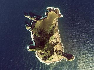
English: Kaminone-island Aerial Photograph
日本語: トカラ列島上ノ根島の空中写真。cku-78-3_c21_2を使用。 |
| Petsa | |
| Gigikanan | 国土情報ウェブマッピングシステム |
| Tagsulat | 国土交通省 |
Pagtugot

|
The copyright holder of this file, the Ministry of Land, Infrastructure, Transport and Tourism of Japan, allows anyone to use it for any purpose, provided that the copyright holder is properly attributed. Redistribution, derivative work, commercial use, and all other use is permitted. |
Attribution:
Copyright © National Land Image Information (Color Aerial Photographs), Ministry of Land, Infrastructure, Transport and Tourism
|
 |
This image is copyrighted by the Ministry of Land, Infrastructure, Transport and Tourism of Japan. For terms of use, see the stipulation to use of National Land Information (in Japanese) and message from MLIT (in Japanese and English). When you display this image on an article, include the following phrase in the description: "Made based on National Land Image Information (Color Aerial Photographs), Ministry of Land, Infrastructure, Transport and Tourism".
|
Kaagi sa payl
I-klik ang petsa/oras aron makit-an ang hulagway sa payl niadtong panahona.
| Petsa/Takna | Thumbnail | Mga dimensyon | Tiggamit | Komento | |
|---|---|---|---|---|---|
| kasamtangan | 13:57, 11 Enero 2011 | | 2,410 × 1,807 (986 KB) | さかおり | {{Information |Description={{en|1=Kaminone-island Aerial Photograph}} {{ja|1=トカラ列島上ノ根島の空中写真。cku-78-3_c21_2を使用。}} |Source=国土情報ウェブマッピングシステム |Author=国土交通省 |Date=1978年 |Permissi |
Mga paggamit sa payl
Ang mosunod nga mga panid misumpay niining payl:
Global nga paggamit sa payl
Kining ubang wiki naggamit ning maong payl:
- Paggamit sa cs.wikipedia.org
- Paggamit sa de.wikipedia.org
- Paggamit sa en.wikipedia.org
- Paggamit sa ja.wikipedia.org
- Paggamit sa ko.wikipedia.org
- Paggamit sa no.wikipedia.org
- Paggamit sa uk.wikipedia.org
- Paggamit sa www.wikidata.org