Payl:Karta PG D´Entrecasteaux isl.PNG
Walay mas taas nga resolusyon.
Karta_PG_D´Entrecasteaux_isl.PNG (300 × 200 pixels, size sa payl: 4 KB, MIME type: image/png)
Mubong sugid:
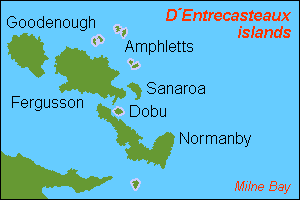
| Deskripsyon |
English: Map (rough) of D´Entrecasteaux islands, Papua New Guinea, own work composed from various mapreferences |
| Petsa | |
| Gigikanan | Kaugalingong trabaho |
| Tagsulat | Hobe / Holger Behr |
Pagtugot
| I, the copyright holder of this work, release this work into the public domain. This applies worldwide. In some countries this may not be legally possible; if so: I grant anyone the right to use this work for any purpose, without any conditions, unless such conditions are required by law. |
Kaagi sa payl
I-klik ang petsa/oras aron makit-an ang hulagway sa payl niadtong panahona.
| Petsa/Takna | Thumbnail | Mga dimensyon | Tiggamit | Komento | |
|---|---|---|---|---|---|
| kasamtangan | 12:13, 12 Mayo 2007 | | 300 × 200 (4 KB) | Hobe | {{Information |Description=map D´Entrecasteaux islands, Papua New Guinea |Source=own work, composed from various mapreferences |Date=2007-04-25 |Author=Holger Behr |Permission= |other_versions= }} |
Mga paggamit sa payl
Ang mosunod nga mga panid misumpay niining payl:
Global nga paggamit sa payl
Kining ubang wiki naggamit ning maong payl:
- Paggamit sa af.wikipedia.org
- Paggamit sa als.wikipedia.org
- Paggamit sa ast.wikipedia.org
- Paggamit sa cs.wikipedia.org
- Paggamit sa de.wikipedia.org
- Paggamit sa en.wikipedia.org
- Paggamit sa eo.wikipedia.org
- Paggamit sa es.wikipedia.org
- Paggamit sa et.wikipedia.org
- Paggamit sa eu.wikipedia.org
- Paggamit sa fa.wikipedia.org
- Paggamit sa fi.wikipedia.org
- Paggamit sa frr.wikipedia.org
- Paggamit sa fr.wikipedia.org
- Paggamit sa gl.wikipedia.org
- Paggamit sa it.wikipedia.org
- Paggamit sa ja.wikipedia.org
- Paggamit sa ka.wikipedia.org
- Paggamit sa ko.wikipedia.org
- Paggamit sa mrj.wikipedia.org
- Paggamit sa nl.wikipedia.org
- Paggamit sa pnb.wikipedia.org
- Paggamit sa ru.wikipedia.org
- Paggamit sa sv.wikipedia.org
- Paggamit sa th.wikipedia.org
- Paggamit sa uk.wikipedia.org
- Paggamit sa vi.wikipedia.org
- Paggamit sa www.wikidata.org
- Paggamit sa xmf.wikipedia.org
View more global usage of this file.