Payl:Karte Insel Usedom.png
Gidak-on ning maong paunang tan-aw: 654 x 600 ka mga piksel. Uban pang mga resoluyon: 262 x 240 ka mga piksel | 524 x 480 ka mga piksel | 838 x 768 ka mga piksel | 1,153 x 1,057 ka mga piksel.
Tibuok resolusyon (1,153 × 1,057 pixels, size sa payl: 458 KB, MIME type: image/png)

|
This map image could be re-created using vector graphics as an SVG file. This has several advantages; see Commons:Media for cleanup for more information. If an SVG form of this image is available, please upload it and afterwards replace this template with
{{vector version available|new image name}}.
It is recommended to name the SVG file “Karte Insel Usedom.svg”—then the template Vector version available (or Vva) does not need the new image name parameter. |
Mubong sugid:
| Deskripsyon |
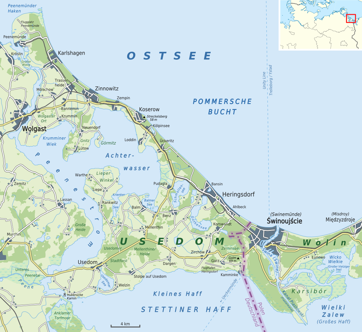
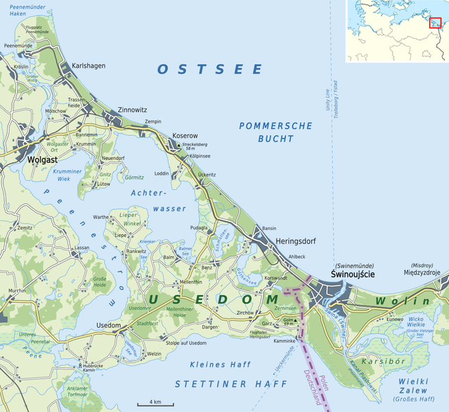
Deutsch: Karte von der Insel Usedom mit den wichtigsten Gemeinden
English: Map of Usedom Island with its most important municipalities |
| Petsa | |
| Gigikanan |
Kaugalingong trabaho |
| Tagsulat | Alexrk2 |
| Other versions |
.png)

|
This map has been made or improved in the German Kartenwerkstatt (Map Lab). You can propose maps to improve as well.
|
Pagtugot
I, the copyright holder of this work, hereby publish it under the following license:
This file is licensed under the Creative Commons Attribution-Share Alike 3.0 Unported license.
- Libre ka:
- sa pagsabwag – sa pagkopya, pag-apod-apod ug pagsabwag sa hinimo
- sa pag-remix – sa pag-adap sa binuhat
- Ubos sa mosunod nga mga kondisyon:
- atribusyon – Kinahanglan nimo nga hatagan ang angay nga kredito, maghatag usa ka link sa lisensya, ug ipakita kung adunay mga pagbag-o. Mahimo nimo kini buhaton sa bisan unsang makatarunganon nga paagi, apan dili sa bisan unsang paagi nga nagsugyot nga gi-endorso ka sa licensor o ang imong paggamit.
- share parehas – Kung imong gi-remix, gibag-o, o gibase sa materyal, kinahanglan nimo nga iapod-apod ang imong mga kontribusyon sa ilawom sa parehas o katugma nga lisensya sama sa orihinal.
Kaagi sa payl
I-klik ang petsa/oras aron makit-an ang hulagway sa payl niadtong panahona.
| Petsa/Takna | Thumbnail | Mga dimensyon | Tiggamit | Komento | |
|---|---|---|---|---|---|
| kasamtangan | 22:36, 7 Hunyo 2015 | | 1,153 × 1,057 (458 KB) | Cmdrjameson | Compressed with pngout. Reduced by 224kB (32% decrease). |
| 15:13, 3 Agosto 2011 |  | 1,153 × 1,057 (682 KB) | Alexrk2 | - | |
| 16:44, 19 Hulyo 2011 |  | 1,170 × 1,072 (694 KB) | Alexrk2 | Hubbrücke Karnin | |
| 16:38, 17 Hulyo 2011 |  | 1,172 × 1,074 (694 KB) | Alexrk2 | Ueckermünde, Wielki Zalew | |
| 12:47, 17 Hulyo 2011 |  | 1,170 × 1,072 (693 KB) | Alexrk2 | colors | |
| 12:02, 17 Hulyo 2011 |  | 1,160 × 1,063 (687 KB) | Alexrk2 | color | |
| 11:51, 17 Hulyo 2011 |  | 1,153 × 1,057 (681 KB) | Alexrk2 | == {{int:filedesc}} == {{Information |Description= {{de|Karte von Usedom}} {{en|Map of Usedom}} |Source={{Own}} * [http://www.openstreetmap.org Openstreetmap] data |Date=2011-07 |Author=Alexrk2 |Perm |
Mga paggamit sa payl
Ang mosunod nga mga panid misumpay niining payl:
Global nga paggamit sa payl
Kining ubang wiki naggamit ning maong payl:
- Paggamit sa an.wikipedia.org
- Paggamit sa ar.wikipedia.org
- Paggamit sa arz.wikipedia.org
- Paggamit sa az.wikipedia.org
- Paggamit sa br.wikipedia.org
- Paggamit sa ca.wikipedia.org
- Paggamit sa cs.wikipedia.org
- Paggamit sa da.wikipedia.org
- Paggamit sa de.wikipedia.org
- Paggamit sa el.wikipedia.org
- Paggamit sa en.wikipedia.org
- Paggamit sa es.wikipedia.org
- Paggamit sa eu.wikipedia.org
- Paggamit sa frr.wikipedia.org
- Paggamit sa fr.wikipedia.org
- Paggamit sa fy.wikipedia.org
- Paggamit sa gl.wikipedia.org
- Paggamit sa hr.wikipedia.org
- Paggamit sa hu.wikipedia.org
- Paggamit sa id.wikipedia.org
- Paggamit sa ka.wikipedia.org
- Paggamit sa ko.wikipedia.org
- Paggamit sa mk.wikipedia.org
- Paggamit sa nl.wikipedia.org
- Paggamit sa no.wikipedia.org
- Paggamit sa pl.wikipedia.org
- Paggamit sa pt.wikipedia.org
- Paggamit sa ro.wikipedia.org
- Paggamit sa ru.wikipedia.org
- Paggamit sa sh.wikipedia.org
- Paggamit sa sv.wikipedia.org
View more global usage of this file.