Payl:LA County Incorporated Areas Calabasas highlighted.svg

Size of this PNG preview of this SVG file: 730 x 599 ka mga piksel. Uban pang mga resoluyon: 292 x 240 ka mga piksel | 585 x 480 ka mga piksel | 935 x 768 ka mga piksel | 1,247 x 1,024 ka mga piksel | 2,494 x 2,048 ka mga piksel | 950 x 780 ka mga piksel.
Tibuok resolusyon (SVG nga payl, nominally 950 × 780 pixels, size sa payl: 261 KB)
Mubong sugid:
| Deskripsyon |
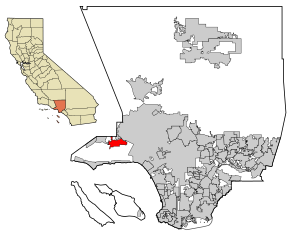
This map shows the incorporated areas in Los Angeles County, California. :*Calabasas is highlighted in red, in the western San Fernando Valley. I created it in Inkscape using data from the Los Angeles County Website (Los Angeles County Incorporated Area and District Map (PDF). |
| Petsa | |
| Gigikanan | My own work, based on public domain information. Though I strove to be as accurate in the detail as possible, the information shown is not guaranteed to be completely accurate. |
| Tagsulat | Ixnayonthetimmay |
| Pagtugot (Paggamit pag-usab niini nga file) |
Public Domain |
| Other versions | See Category:Maps of Los Angeles County for other versions of this image. |
Pagtugot
| I, the copyright holder of this work, release this work into the public domain. This applies worldwide. In some countries this may not be legally possible; if so: I grant anyone the right to use this work for any purpose, without any conditions, unless such conditions are required by law. |
Kaagi sa payl
I-klik ang petsa/oras aron makit-an ang hulagway sa payl niadtong panahona.
| Petsa/Takna | Thumbnail | Mga dimensyon | Tiggamit | Komento | |
|---|---|---|---|---|---|
| kasamtangan | 04:53, 29 Hunyo 2007 | | 950 × 780 (261 KB) | Ixnayonthetimmay | == Summary == {{Information |Description=This map shows the incorporated areas in Los Angeles County, California. Calabasas is highlighted in red. |
Mga paggamit sa payl
Ang mosunod nga mga panid misumpay niining payl:
Global nga paggamit sa payl
Kining ubang wiki naggamit ning maong payl:
- Paggamit sa ar.wikipedia.org
- Paggamit sa arz.wikipedia.org
- Paggamit sa ca.wikipedia.org
- Paggamit sa de.wikipedia.org
- Paggamit sa eo.wikipedia.org
- Paggamit sa es.wikipedia.org
- Paggamit sa eu.wikipedia.org
- Paggamit sa fa.wikipedia.org
- Paggamit sa fr.wikipedia.org
- Paggamit sa ht.wikipedia.org
- Paggamit sa hu.wikipedia.org
- Paggamit sa pl.wikipedia.org
- Paggamit sa ro.wikipedia.org
- Paggamit sa ru.wikipedia.org
- Paggamit sa sr.wikipedia.org
- Paggamit sa sw.wikipedia.org
- Paggamit sa tt.wikipedia.org
- Paggamit sa vo.wikipedia.org
- Paggamit sa www.wikidata.org
- Paggamit sa zh-min-nan.wikipedia.org