Payl:Landsat IzuOshima Island.jpg

Gidak-on ning maong paunang tan-aw: 433 x 599 ka mga piksel. Uban pang mga resoluyon: 173 x 240 ka mga piksel | 600 x 830 ka mga piksel.
Tibuok resolusyon (600 × 830 pixels, size sa payl: 197 KB, MIME type: image/jpeg)
Mubong sugid:
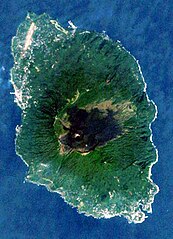
| Deskripsyon |
English: Landsat image of the Izu Oshima island, Izu islands, Japan
日本語: ランドサットの衛星写真→カシミールにて読み込み→補正 |
||
| Petsa | |||
| Gigikanan |
The Landsat satellite pictures are used for this image. The data came from Global Land Cover Facility (GLCF), and are processed with Kashmir 3D.
|
||
| Tagsulat |
|
Pagtugot
| This file is licensed under the Creative Commons Attribution-Share Alike 3.0 Unported license. Subject to disclaimers. | ||
| ||
| This licensing tag was added to this file as part of the GFDL licensing update. |

|
Gitugot ang pagkopya, pag-apud-apod o/ug pag-usab ning maong dokumento ubos sa mga termino sa GNU Free Documentation License, Version 1.2 o mas bag-ong bersiyon nga gimantala sa Free Software Foundation; nga walay Invariant Sections, walay Front-Cover Texts, ug walay Back-Cover Texts. Ang kopya sa lisensiya gilakip sa bahin nga giulohang GNU Free Documentation License. Subject to disclaimers. |
Kaagi sa payl
I-klik ang petsa/oras aron makit-an ang hulagway sa payl niadtong panahona.
| Petsa/Takna | Thumbnail | Mga dimensyon | Tiggamit | Komento | |
|---|---|---|---|---|---|
| kasamtangan | 05:28, 28 Nobiyembre 2020 | | 600 × 830 (197 KB) | Togabi | Color Adjustment. |
| 04:29, 5 Hulyo 2006 |  | 378 × 523 (40 KB) | Taichi | Landsat image of the Izu Oshima island, Izu islands, Japan '''Source:''' ja:画像:伊豆大島の衛星写真001.jpg {{Landsat}} | |
| 14:15, 12 Oktubre 2004 |  | 378 × 523 (40 KB) | っ | 恐らくPD。ランドサットの衛星写真→カシミールにて読み込み→補正 |
Mga paggamit sa payl
Ang mosunod nga mga panid misumpay niining payl:
Global nga paggamit sa payl
Kining ubang wiki naggamit ning maong payl:
- Paggamit sa ar.wikipedia.org
- Paggamit sa az.wikipedia.org
- Paggamit sa ca.wikipedia.org
- Paggamit sa ckb.wikipedia.org
- Paggamit sa cs.wikipedia.org
- Paggamit sa de.wikipedia.org
- Paggamit sa en.wikipedia.org
- Paggamit sa en.wikivoyage.org
- Paggamit sa es.wikipedia.org
- Paggamit sa et.wikipedia.org
- Paggamit sa eu.wikipedia.org
- Paggamit sa fa.wikipedia.org
- Paggamit sa fi.wikipedia.org
- Paggamit sa frr.wikipedia.org
- Paggamit sa he.wikipedia.org
- Paggamit sa hy.wikipedia.org
- Paggamit sa it.wikipedia.org
- Paggamit sa ja.wikipedia.org
- Paggamit sa ko.wikipedia.org
- Paggamit sa lt.wikipedia.org
- Paggamit sa mr.wikipedia.org
- Paggamit sa no.wikipedia.org
- Paggamit sa pt.wikipedia.org
- Paggamit sa ro.wikipedia.org
- Paggamit sa ru.wikipedia.org
- Paggamit sa simple.wikipedia.org
- Paggamit sa sv.wikipedia.org
- Paggamit sa tr.wikipedia.org
- Paggamit sa uk.wikipedia.org
- Paggamit sa vi.wikipedia.org
- Paggamit sa www.wikidata.org