Payl:Livingston-Island-Map-2010.jpg

Gidak-on ning maong paunang tan-aw: 800 x 555 ka mga piksel. Uban pang mga resoluyon: 320 x 222 ka mga piksel | 640 x 444 ka mga piksel | 1,024 x 710 ka mga piksel | 1,280 x 888 ka mga piksel | 2,560 x 1,776 ka mga piksel | 5,027 x 3,487 ka mga piksel.
Tibuok resolusyon (5,027 × 3,487 pixels, size sa payl: 7.07 MB, MIME type: image/jpeg)
Mubong sugid:
| Deskripsyon |
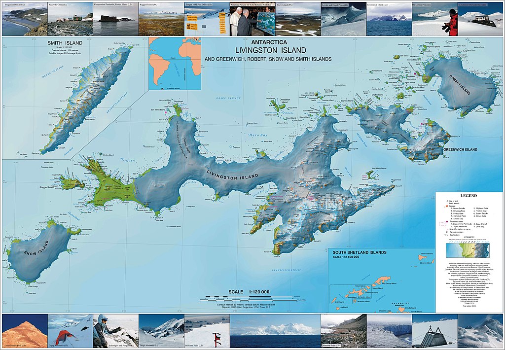
English: L.L. Ivanov. Antarctica: Livingston Island and Greenwich, Robert, Snow and Smith Islands. Scale 1:120000 topographic map. Troyan: Manfred Wörner Foundation, 2010. ISBN 978-954-92032-9-5 (First edition 2009. ISBN 978-954-92032-6-4) |
| Petsa | |
| Gigikanan | Kaugalingong trabaho |
| Tagsulat | Apcbg |
| Pagtugot (Paggamit pag-usab niini nga file) |
Pagtugot
I, the copyright holder of this work, hereby publish it under the following license:
This file is licensed under the Creative Commons Attribution-Share Alike 4.0 International license.
- Libre ka:
- sa pagsabwag – sa pagkopya, pag-apod-apod ug pagsabwag sa hinimo
- sa pag-remix – sa pag-adap sa binuhat
- Ubos sa mosunod nga mga kondisyon:
- atribusyon – Kinahanglan nimo nga hatagan ang angay nga kredito, maghatag usa ka link sa lisensya, ug ipakita kung adunay mga pagbag-o. Mahimo nimo kini buhaton sa bisan unsang makatarunganon nga paagi, apan dili sa bisan unsang paagi nga nagsugyot nga gi-endorso ka sa licensor o ang imong paggamit.
- share parehas – Kung imong gi-remix, gibag-o, o gibase sa materyal, kinahanglan nimo nga iapod-apod ang imong mga kontribusyon sa ilawom sa parehas o katugma nga lisensya sama sa orihinal.
Published by the Manfred Wörner Foundation, and hereby released by the Foundation’s President and CEO Apcbg (Lyubomir Ivanov) for publication under the Creative Commons Attribution ShareAlike 4.0 license.
Kaagi sa payl
I-klik ang petsa/oras aron makit-an ang hulagway sa payl niadtong panahona.
| Petsa/Takna | Thumbnail | Mga dimensyon | Tiggamit | Komento | |
|---|---|---|---|---|---|
| kasamtangan | 04:46, 29 Hunyo 2015 | | 5,027 × 3,487 (7.07 MB) | Apcbg | {{Information |Description ={{en|1= L.L. Ivanov. Antarctica: Livingston Island and Greenwich, Robert, Snow and Smith Islands. Scale 1:120000 topographic map. Troyan: Manfred Wörner Foundation, 2010. ISBN 978-954-92032-9-5 (First edition 2009. ISBN... |
Mga paggamit sa payl
Ang mosunod nga mga panid misumpay niining payl:
Global nga paggamit sa payl
Kining ubang wiki naggamit ning maong payl:
- Paggamit sa af.wikipedia.org
- Paggamit sa ar.wikipedia.org
- Paggamit sa ast.wikipedia.org
- Paggamit sa az.wikipedia.org
- Cənubi Şetland adaları
- Mikalvi buxtası
- Kruni buxtası
- Zahari burnu
- Neqra burnu
- Edvards burnu
- Robert burnu
- Tsepina buxtası
- Somovit burnu
- Batuliya burnu
- Sadala burnu
- Kitçen burnu
- Smirnenski burnu
- Qarinya buxtası
- Qrinviç adası
- Misnomer burnu
- Debelyanov burnu
- Hammer burnu
- Nevestino buxtası
- Katarina burnu
- Kozloduy buxtası
- Perelik burnu
- Vrabça buxtası
- Yundola buxtası
- Lavrenov burnu
- Uqarçi burnu
- Hidra buxtası
- Zornitsa buxtası
- Skesa burnu
- Rove burnu
- Nedelya burnu
- Bilyar burnu
- Sparadok burnu
- Livinqston adası
- Lakatnik burnu
- Lista burnu
- Amadok burnu
- Kokalyane burnu
- Uqain burnu
- İrnik burnu
- Mezdra burnu
- Byevoter burnu
- Esteverena burnu
- Monroye burnu
- Barutin buxtası
- Vokil burnu
- İvaylo buxtası
View more global usage of this file.