Payl:LocationAntiguaAndBarbuda.png
Walay mas taas nga resolusyon.
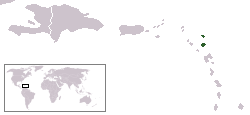
LocationAntiguaAndBarbuda.png (250 × 115 pixels, size sa payl: 5 KB, MIME type: image/png)

|
File:Antigua and Barbuda in its region (zoomed).svg is a vector version of this file. It should be used in place of this PNG file.
File:LocationAntiguaAndBarbuda.png → File:Antigua and Barbuda in its region (zoomed).svg
For more information, see Help:SVG. |
.svg) |
Location map for Antigua and Barbuda.
Originally created for English Wikipedia by Vardion.
| |
This work has been released into the public domain by its author, Vardion, at the English Wikipedya project. This applies worldwide. In case this is not legally possible: |
Kaagi sa payl
I-klik ang petsa/oras aron makit-an ang hulagway sa payl niadtong panahona.
| Petsa/Takna | Thumbnail | Mga dimensyon | Tiggamit | Komento | |
|---|---|---|---|---|---|
| kasamtangan | 19:40, 19 Disyembre 2004 | | 250 × 115 (5 KB) | EugeneZelenko | Location map for the Antigua and Barbuda.<br/>Originally created for English Wikipedia by Vardion.<br/>{{PD}}<br/>Category:Country locator maps |
Mga paggamit sa payl
Ang mosunod nga 2 panid misumpay niining payl:
Global nga paggamit sa payl
Kining ubang wiki naggamit ning maong payl:
- Paggamit sa ar.wikipedia.org
- Paggamit sa arz.wikipedia.org
- Paggamit sa ast.wikipedia.org
- Paggamit sa azb.wikipedia.org
- Paggamit sa az.wiktionary.org
- Paggamit sa be-tarask.wikipedia.org
- Paggamit sa be.wikipedia.org
- Paggamit sa bg.wikipedia.org
- Paggamit sa bn.wikipedia.org
- Paggamit sa bo.wikipedia.org
- Paggamit sa bpy.wikipedia.org
- Paggamit sa ckb.wikipedia.org
- Paggamit sa dsb.wikipedia.org
- Paggamit sa en.wikipedia.org
- Paggamit sa eo.wikipedia.org
- Paggamit sa es.wikipedia.org
- Paggamit sa es.wikinews.org
- Paggamit sa eu.wikipedia.org
- Paggamit sa eu.wiktionary.org
- Paggamit sa ext.wikipedia.org
- Paggamit sa fa.wikipedia.org
- Paggamit sa fa.wikivoyage.org
- Paggamit sa fiu-vro.wikipedia.org
- Paggamit sa fr.wikipedia.org
- Paggamit sa fr.wiktionary.org
- Paggamit sa fy.wikipedia.org
- Paggamit sa gag.wikipedia.org
- Paggamit sa gv.wikipedia.org
- Paggamit sa he.wikivoyage.org
View more global usage of this file.