Payl:Location map Pamir mhn.svg

Size of this PNG preview of this SVG file: 800 x 389 ka mga piksel. Uban pang mga resoluyon: 320 x 156 ka mga piksel | 640 x 312 ka mga piksel | 1,024 x 498 ka mga piksel | 1,280 x 623 ka mga piksel | 2,560 x 1,246 ka mga piksel | 1,399 x 681 ka mga piksel.
Tibuok resolusyon (SVG nga payl, nominally 1,399 × 681 pixels, size sa payl: 1.11 MB)

Mubong sugid:
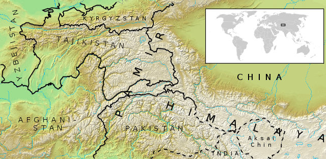
| Deskripsyon | Location map for Pamir mountains |
| Petsa | |
| Gigikanan | A map from demis.nl (PD) with borders and country names added. |
| Tagsulat | Mats Halldin |
| Pagtugot (Paggamit pag-usab niini nga file) |
GFDL, CC-BY, PD |
| Other versions | Image:Location_map_Pamir_mhn2.svg |
| I, the copyright holder of this work, release this work into the public domain. This applies worldwide. In some countries this may not be legally possible; if so: I grant anyone the right to use this work for any purpose, without any conditions, unless such conditions are required by law. |
Pagtugot
I, the copyright holder of this work, hereby publish it under the following licenses:

|
Gitugot ang pagkopya, pag-apud-apod o/ug pag-usab ning maong dokumento ubos sa mga termino sa GNU Free Documentation License, Version 1.2 o mas bag-ong bersiyon nga gimantala sa Free Software Foundation; nga walay Invariant Sections, walay Front-Cover Texts, ug walay Back-Cover Texts. Ang kopya sa lisensiya gilakip sa bahin nga giulohang GNU Free Documentation License. |
| This file is licensed under the Creative Commons Attribution-Share Alike 3.0 Unported license. | ||
| ||
| This licensing tag was added to this file as part of the GFDL licensing update. |
This file is licensed under the Creative Commons Attribution-Share Alike 2.5 Generic, 2.0 Generic and 1.0 Generic license.
- Libre ka:
- sa pagsabwag – sa pagkopya, pag-apod-apod ug pagsabwag sa hinimo
- sa pag-remix – sa pag-adap sa binuhat
- Ubos sa mosunod nga mga kondisyon:
- atribusyon – Kinahanglan nimo nga hatagan ang angay nga kredito, maghatag usa ka link sa lisensya, ug ipakita kung adunay mga pagbag-o. Mahimo nimo kini buhaton sa bisan unsang makatarunganon nga paagi, apan dili sa bisan unsang paagi nga nagsugyot nga gi-endorso ka sa licensor o ang imong paggamit.
- share parehas – Kung imong gi-remix, gibag-o, o gibase sa materyal, kinahanglan nimo nga iapod-apod ang imong mga kontribusyon sa ilawom sa parehas o katugma nga lisensya sama sa orihinal.
You may select the license of your choice.
librsvg bug
This image shows a bug. At full size the map does not show. It does show at 200px.
Kaagi sa payl
I-klik ang petsa/oras aron makit-an ang hulagway sa payl niadtong panahona.
| Petsa/Takna | Thumbnail | Mga dimensyon | Tiggamit | Komento | |
|---|---|---|---|---|---|
| kasamtangan | 01:23, 7 Mayo 2007 | | 1,399 × 681 (1.11 MB) | Nosignup~commonswiki | |
| 00:52, 7 Mayo 2007 |  | 1,755 × 890 (1.08 MB) | Nosignup~commonswiki | Reverted to earlier revision | |
| 00:52, 7 Mayo 2007 | No thumbnail | (1.01 MB) | Nosignup~commonswiki | Reverted to earlier revision | |
| 00:45, 7 Mayo 2007 |  | 1,755 × 890 (1.08 MB) | Nosignup~commonswiki | ||
| 00:33, 7 Mayo 2007 |  | 1,755 × 890 (1.01 MB) | Nosignup~commonswiki | ||
| 13:37, 20 Disyembre 2006 | No thumbnail | (1.01 MB) | Mats Halldin~commonswiki | {{Information |Description=Location map for Pamir mountains |Source=A map from demis.nl (PD) with borders and country names added. |Date=dec 20, 2006 |Author=~~~ |Permission=GFDL, CC-BY, PD |other_versions=None }} {{PD-self}} [[Category:Maps of Tajikista |
Mga paggamit sa payl
Ang mosunod nga mga panid misumpay niining payl:
Global nga paggamit sa payl
Kining ubang wiki naggamit ning maong payl:
- Paggamit sa ast.wikipedia.org
- Paggamit sa az.wikipedia.org
- Paggamit sa ba.wikipedia.org
- Paggamit sa be-tarask.wikipedia.org
- Paggamit sa bg.wikipedia.org
- Paggamit sa br.wikipedia.org
- Paggamit sa ca.wikipedia.org
- Paggamit sa ckb.wikipedia.org
- Paggamit sa cy.wikipedia.org
- Paggamit sa da.wikipedia.org
- Paggamit sa de.wikipedia.org
- Paggamit sa el.wikipedia.org
- Paggamit sa en.wikipedia.org
- Paggamit sa en.wikivoyage.org
- Paggamit sa eo.wikipedia.org
- Paggamit sa es.wikipedia.org
- Paggamit sa eu.wikipedia.org
- Paggamit sa fi.wikipedia.org
- Paggamit sa fr.wiktionary.org
- Paggamit sa he.wikipedia.org
- Paggamit sa he.wikivoyage.org
- Paggamit sa hi.wikipedia.org
- Paggamit sa hr.wikipedia.org
- Paggamit sa hu.wikipedia.org
- Paggamit sa hy.wikipedia.org
- Paggamit sa ie.wikipedia.org
- Paggamit sa incubator.wikimedia.org
- Paggamit sa ja.wikipedia.org
- Paggamit sa ko.wikipedia.org
- Paggamit sa lld.wikipedia.org
- Paggamit sa mk.wikipedia.org
- Paggamit sa nl.wikipedia.org
- Paggamit sa no.wikipedia.org
- Paggamit sa pa.wikipedia.org
- Paggamit sa pnb.wikipedia.org
- Paggamit sa pt.wikipedia.org
- Paggamit sa ru.wikipedia.org
- Paggamit sa ru.wikinews.org
- Paggamit sa sl.wikipedia.org
- Paggamit sa tt.wikipedia.org
- Paggamit sa ug.wikipedia.org
- Paggamit sa uk.wikipedia.org
- Paggamit sa ur.wikipedia.org
- Paggamit sa vi.wikipedia.org
- Paggamit sa www.wikidata.org
View more global usage of this file.