Payl:Madang (Flughafen).jpg

Gidak-on ning maong paunang tan-aw: 800 x 540 ka mga piksel. Uban pang mga resoluyon: 320 x 216 ka mga piksel | 640 x 432 ka mga piksel | 1,024 x 691 ka mga piksel | 1,280 x 864 ka mga piksel | 1,530 x 1,033 ka mga piksel.
Tibuok resolusyon (1,530 × 1,033 pixels, size sa payl: 133 KB, MIME type: image/jpeg)
.jpg)
Mubong sugid:
| Deskripsyon |
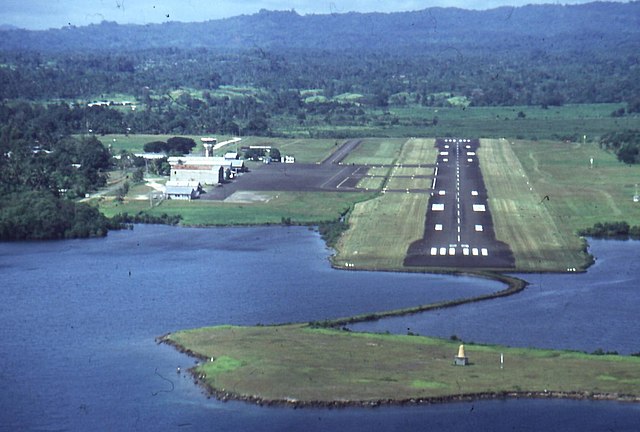
Deutsch: Dies ist der Madanger Flughafen, schön am Hafen zur Südsee gelegen. |
| Petsa | circa 1990 |
| Gigikanan | Privat |
| Tagsulat | K. Winarske |
| Object location | | View this and other nearby images on: OpenStreetMap |
|---|
.jpg¶ms=-05.208333_N_0145.783333_E_globe:Earth_class:object_region:PG_type:landmark_&language=ceb)
Pagtugot

|
This work is free software; you can redistribute it and/or modify it under the terms of the GNU General Public License as published by the Free Software Foundation; either version 2 of the License, or any later version. This work is distributed in the hope that it will be useful, but without any warranty; without even the implied warranty of merchantability or fitness for a particular purpose. See version 2 and version 3 of the GNU General Public License for more details. |
Kaagi sa payl
I-klik ang petsa/oras aron makit-an ang hulagway sa payl niadtong panahona.
| Petsa/Takna | Thumbnail | Mga dimensyon | Tiggamit | Komento | |
|---|---|---|---|---|---|
| kasamtangan | 18:49, 24 Mayo 2006 | | 1,530 × 1,033 (133 KB) | JonathanWinarske | *Bildbeschreibung: Dies ist der Madanger Flughafen, schön am Hafen zur Südsee gelegen. *Quelle: Privat *Fotograf/Zeichner: K. Winarske *Datum: ca. 1990 |
Mga paggamit sa payl
Ang mosunod nga mga panid misumpay niining payl:
Global nga paggamit sa payl
Kining ubang wiki naggamit ning maong payl:
- Paggamit sa als.wikipedia.org
- Paggamit sa ar.wikipedia.org
- Paggamit sa de.wikipedia.org
- Paggamit sa en.wikipedia.org
- Paggamit sa fa.wikipedia.org
- Paggamit sa fr.wikipedia.org
- Paggamit sa gl.wikipedia.org
- Paggamit sa he.wikipedia.org
- Paggamit sa ja.wikipedia.org
- Paggamit sa ko.wikipedia.org
- Paggamit sa lez.wikipedia.org
- Paggamit sa lt.wikipedia.org
- Paggamit sa pl.wikipedia.org
- Paggamit sa ru.wikipedia.org
- Paggamit sa uk.wikipedia.org
- Paggamit sa www.wikidata.org
- Paggamit sa zh.wikipedia.org
.jpg)