Payl:Malaysia location map.svg

Size of this PNG preview of this SVG file: 800 x 305 ka mga piksel. Uban pang mga resoluyon: 320 x 122 ka mga piksel | 640 x 244 ka mga piksel | 1,024 x 390 ka mga piksel | 1,280 x 487 ka mga piksel | 2,560 x 975 ka mga piksel | 1,200 x 457 ka mga piksel.
Tibuok resolusyon (SVG nga payl, nominally 1,200 × 457 pixels, size sa payl: 499 KB)
Mubong sugid:
| Deskripsyon |
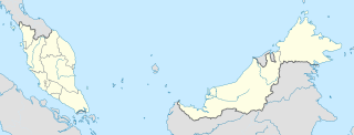
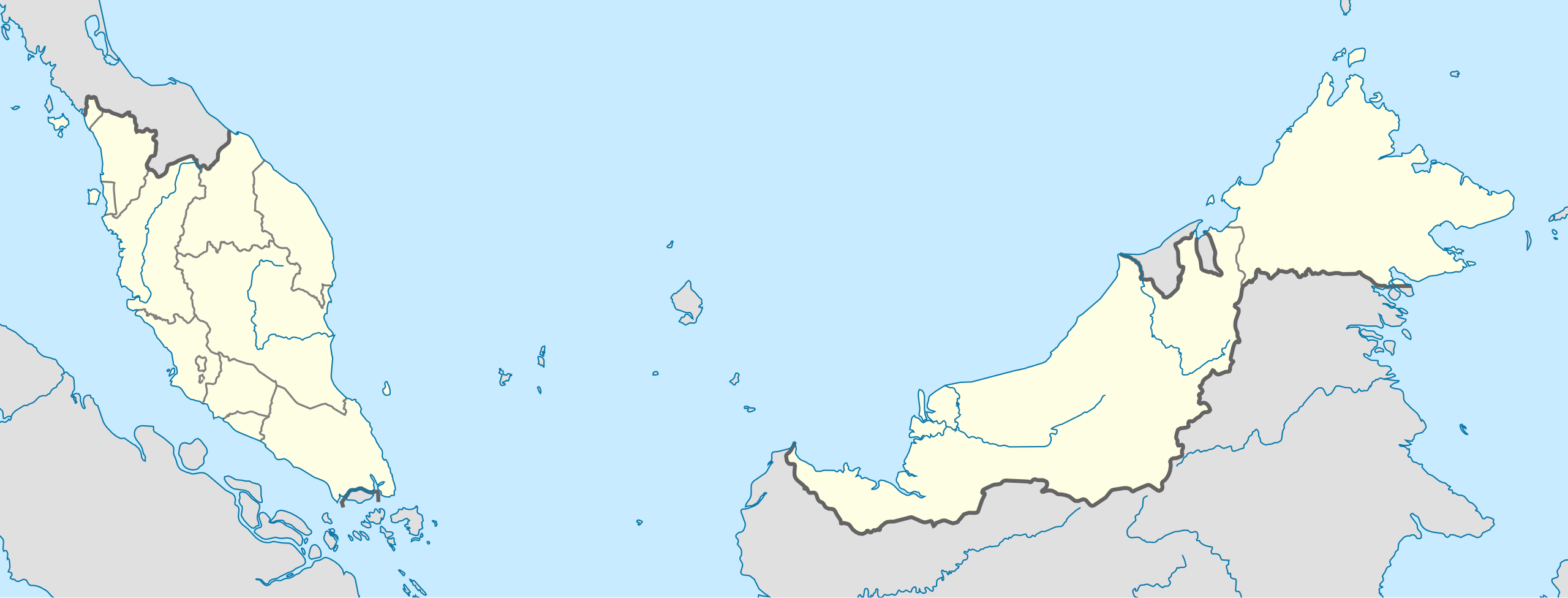
English: Location map of Malaysia.
Equirectangular projection. Strechted by 100.0%. Geographic limits of the map: * N: 8.0° N * S: 0.0° N * W: 99.0° E * E: 120.0° EMade with Natural Earth. Free vector and raster map data @ naturalearthdata.com. |
| Petsa | |
| Gigikanan | Kaugalingong trabaho |
| Tagsulat | Uwe Dedering |
| Other versions |
|
Pagtugot
I, the copyright holder of this work, hereby publish it under the following licenses:
This file is licensed under the Creative Commons Attribution-Share Alike 3.0 Unported license.
- Libre ka:
- sa pagsabwag – sa pagkopya, pag-apod-apod ug pagsabwag sa hinimo
- sa pag-remix – sa pag-adap sa binuhat
- Ubos sa mosunod nga mga kondisyon:
- atribusyon – Kinahanglan nimo nga hatagan ang angay nga kredito, maghatag usa ka link sa lisensya, ug ipakita kung adunay mga pagbag-o. Mahimo nimo kini buhaton sa bisan unsang makatarunganon nga paagi, apan dili sa bisan unsang paagi nga nagsugyot nga gi-endorso ka sa licensor o ang imong paggamit.
- share parehas – Kung imong gi-remix, gibag-o, o gibase sa materyal, kinahanglan nimo nga iapod-apod ang imong mga kontribusyon sa ilawom sa parehas o katugma nga lisensya sama sa orihinal.

|
Gitugot ang pagkopya, pag-apud-apod o/ug pag-usab ning maong dokumento ubos sa mga termino sa GNU Free Documentation License, Version 1.2 o mas bag-ong bersiyon nga gimantala sa Free Software Foundation; nga walay Invariant Sections, walay Front-Cover Texts, ug walay Back-Cover Texts. Ang kopya sa lisensiya gilakip sa bahin nga giulohang GNU Free Documentation License. |
You may select the license of your choice.
Kaagi sa payl
I-klik ang petsa/oras aron makit-an ang hulagway sa payl niadtong panahona.
| Petsa/Takna | Thumbnail | Mga dimensyon | Tiggamit | Komento | |
|---|---|---|---|---|---|
| kasamtangan | 13:45, 22 Pebrero 2010 | 1,200 × 457 (499 KB) | Uwe Dedering | complete new version with right projection and colors | |
| 23:31, 18 Hulyo 2009 | 1,170 × 400 (540 KB) | Mdzafri | more detailed map. | ||
| 16:38, 9 Pebrero 2009 | 1,171 × 400 (558 KB) | Doctor Dodge | resized to 400 x 1170 | ||
| 14:43, 9 Pebrero 2009 | 3,000 × 1,025 (558 KB) | Doctor Dodge | {{Information |Description={{en|1=Location map for Malaysia}} |Source=Own work by uploader |Author=Doctor Dodge |Date=9 febbraio 2009 |Permission= |other_versions= }} <!--{{ImageUpload|full}}--> Category:Location maps of Asia |
Mga paggamit sa payl
More than 100 pages use this file. The following list shows the first 100 pages that use this file only. A full list is available.
- Babi
- Beaufort
- Betty
- Black Point
- Black Rock
- Bukit Pisang
- Bukit Sagan
- Bukit Stapok
- Butterworth
- Castle Peak
- Cone Hill
- Deep Creek
- East Hill
- East Peak
- Evans Island
- George Town
- Gut Island
- Jaga
- Kalai
- Kota
- Kuli
- Kunak
- Labok
- Lamas
- Lata
- Little Island
- Long Island
- Mambo
- Mangrove Point
- Martin Ridge
- Miri
- Munda (pagklaro)
- Naga (pagklaro)
- North Channel
- Pahu
- Pin (pagklaro)
- Pyramid Hill
- Quoin Hill
- Rock Peak
- Saddle Hill
- Saddle Island
- Sagan A Bukit
- Sail Rock
- Sandy Cay
- Sandy Island
- Scotts Hill
- Shoal Point
- Sok
- South Channel
- South Point
- Stewart Peak
- Stork Rock
- Sungai Belar
- Sungai Rujak
- Sungai Sagut
- Sungai Salar
- Sungai Satu
- Sungai Sawak
- Sungai Sebanyak
- Sungai Sebatu
- Sungai Selangan
- Sungai Seria
- Sungai Sibut
- Sungai Sipan
- Sungai Sukin
- Sungai Sunan
- Sungai Supon
- Sungai Tajau
- Sungai Tali
- Sungai Tampoi
- Sungai Tampui
- Sungai Taong
- Sungai Tasek
- Sungai Tekoyong
- Sungai Tekuyong
- Sungai Temawai
- Sungai Temiang
- Sungai Tengah
- Sungai Tepam
- Sungai Teraja
- Sungai Teritip
- Sungai Tian
- Sungai Tiga
- Sungai Tuan
- Sungai Tungku
- Sungai Tutong
- Sungai Ukong
- Sungai Wasai
- Sungai Yu
- Sungai Yul
- Sungei Sabatu
- Table Hill
- Tanjong Teritip
- The Narrows
- Tree Island
- Turtle Island
- Turtle Rock
- Victoria
- Victoria Town
- Wedge Rock
View more links to this file.
Global nga paggamit sa payl
Kining ubang wiki naggamit ning maong payl:
- Paggamit sa ace.wikipedia.org
- Paggamit sa af.wikipedia.org
- Paggamit sa an.wikipedia.org
- Paggamit sa ar.wikipedia.org
- Paggamit sa ast.wikipedia.org
- Gran Premiu de Malasia de 2007
- Gran Premiu de Malasia de 2006
- Gran Premiu de Malasia de 2008
- Torres Petronas
- Menara Telekom
- Kuala Lumpur
- Aeropuertu Internacional de Penang - Malasia
- Putrajaya
- George Town
- Petaling Jaya
- Estadiu Nacional Bukit Jalil
- Península de Malaca
- Estrechu de Singapur
- Estrechu de Johor
- Torre de Kuala Lumpur
- Kuching
- Ipoh
- Malasia Peninsular
- Alor Setar
- Kota Kinabalu
- Johor Bahru
- Módulu:Mapa de llocalización/datos/Malasia
- Módulu:Mapa de llocalización/datos/Malasia/usu
- Aeropuertu Internacional de Kuala Lumpur
- Sepang
- Circuitu Internacional de Sepang
- Aeropuertu de Tawau
- Puertu de Johor
- Puertu de Kemaman
- Semporna
- Islla Tengah
- Paggamit sa azb.wikipedia.org
- Paggamit sa az.wikipedia.org
View more global usage of this file.