Payl:Mali2 location map.svg

Tibuok resolusyon (SVG nga payl, nominally 1,644 × 1,568 pixels, size sa payl: 297 KB)
Mubong sugid:
| Deskripsyon |
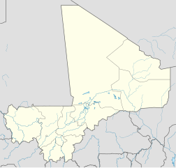
Deutsch: Positionskarte von Mali
Quadratische Plattkarte, N-S-Streckung 105 %. Geographische Begrenzung der Karte:
English: Location map of Mali
Equirectangular projection, N/S stretching 105 %. Geographic limits of the map:
|
||
| Petsa | |||
| Gigikanan |
Kaugalingong trabaho, using
|
||
| Tagsulat | NordNordWest | ||
| Pagtugot (Paggamit pag-usab niini nga file) |
This file is licensed under the Creative Commons Attribution-Share Alike 3.0 Germany license.
 This file is licensed under the Creative Commons Attribution-Share Alike 3.0 Germany license.
|
||
| Other versions |
|
||
| SVG genesis | This map was created with Adobe Illustrator.
|


Kaagi sa payl
I-klik ang petsa/oras aron makit-an ang hulagway sa payl niadtong panahona.
| Petsa/Takna | Thumbnail | Mga dimensyon | Tiggamit | Komento | |
|---|---|---|---|---|---|
| kasamtangan | 14:52, 22 Marso 2010 | | 1,644 × 1,568 (297 KB) | NordNordWest | c |
| 10:57, 22 Marso 2010 |  | 1,644 × 1,568 (296 KB) | NordNordWest | c | |
| 17:43, 21 Marso 2010 |  | 1,644 × 1,568 (295 KB) | NordNordWest | =={{int:filedesc}}== {{Information |Description= {{de|Positionskarte von Mali}} Quadratische Plattkarte, N-S-Streckung 105 %. Geographische Begrenzung der Karte: * N: 25.5° N * S: 9.7° N * W: 12.6° W * O: 4.8° O {{en|Location map of [[:en |
Mga paggamit sa payl
More than 100 pages use this file. The following list shows the first 100 pages that use this file only. A full list is available.
- Aba
- Agarak
- Ba (pagklaro)
- Bala
- Bale
- Balé
- Bamba
- Bangao
- Bango
- Bankoré
- Bara (pagklaro)
- Barcha
- Bayé
- Birou
- Bondo
- Bone
- Borna
- Bouari
- Bouli
- Dabara
- Danga
- Dara
- Dassa
- Diadia
- Dogora
- Dougo
- Erna (pagklaro)
- Fala (pagklaro)
- Farakoba
- Gamba
- Gari (pagklaro)
- Garia
- Garou
- Gaïkindé
- Go
- Gue
- Gué
- Inis
- Kaina
- Kan
- Kifa
- Kita
- Koba
- Kobani
- Kobila
- Koble
- Kobolo
- Kodiala
- Kodialani
- Koko
- Kombo
- Kore
- Koro
- Koroma
- Koré
- Kouele
- Koutiala
- Kouélé
- Koya
- Leba
- Lenga
- Loloro
- Malala (pagklaro)
- Massa
- Mbali
- Mene (pagklaro)
- Mola (pagklaro)
- Nanougou
- Nena
- Niania
- Oukoulourou
- Oula Department
- Ourou
- Roy
- Samba (pagklaro)
- Santou
- Sebetou
- Segou
- Sele
- Sirakoro
- Sirou
- Soala
- Sola
- Soum
- Sountou
- Ségou
- Tala
- Tanda
- Tarach
- Teze
- Ti-n-Aray
- Tite
- Tolé
- Tongi
- Tori
- Toyla
- Wabou
- Wango
- Woli
- Zina
View more links to this file.
Global nga paggamit sa payl
Kining ubang wiki naggamit ning maong payl:
- Paggamit sa ckb.wikipedia.org
- Paggamit sa de.wikipedia.org
- Paggamit sa eo.wikipedia.org
- Paggamit sa fr.wikinews.org
- Paggamit sa id.wikipedia.org
- Paggamit sa kbd.wikipedia.org
- Paggamit sa ku.wikipedia.org
- Paggamit sa mr.wikipedia.org
- Paggamit sa pa.wikipedia.org
- Paggamit sa pl.wikibooks.org
- Paggamit sa pt.wikipedia.org
- Paggamit sa sk.wikipedia.org
- Paggamit sa sv.wikivoyage.org
- Paggamit sa war.wikipedia.org